The more recent wind slabs represent the main danger. Avalanches can penetrate down to the ground and reach medium size. Increase in danger of moist and wet snow slides as a consequence of warming during the day and solar radiation.
Snowpack
dp.6: cold, loose snow and wind dp.1: deep persistent weak layer
As a consequence of a strong to storm force wind from northerly directions, sometimes large wind slabs formed in the last few days in particular in gullies and bowls and behind abrupt changes in the terrain. The fresh wind slabs are lying on the unfavourable surface of an old snowpack in all aspects and generally above the tree line. Sunshine and high temperatures will give rise as the day progresses to moistening of the snowpack below approximately 2500 m.
Tendency
Saturday: The avalanche danger will persist.
EARLIER Danger level
treeline
Avalanche Problem
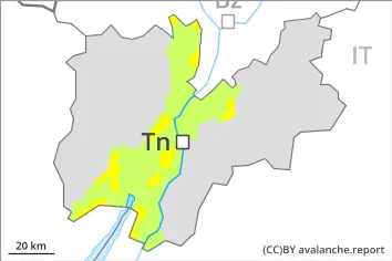
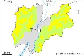
Wind slab
Treeline
Persistent weak layer
Treeline
LATER Danger level
treeline
Avalanche Problem
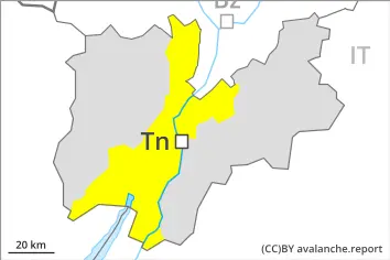
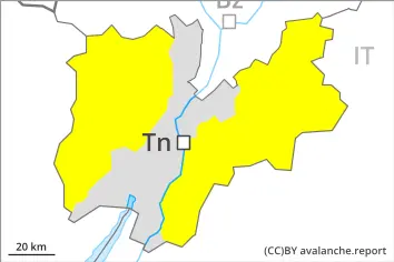
Wind slab
Treeline
Persistent weak layer
Treeline
Wet snow
2500m
Wind slabs and weakly bonded old snow require caution.
Avalanches can be released, in particular by large loads. This applies in particular above the tree line, as well as at transitions from a shallow to a deep snowpack, when entering gullies and bowls for example. Precarious weak layers exist in the old snowpack on very steep shady slopes. These avalanche prone locations are to be found in particular in east to north to west facing aspects. Medium-sized and, in isolated cases, large avalanches are possible especially adjacent to ridgelines and in gullies and bowls. Increase in danger of moist and wet snow slides as a consequence of warming during the day and solar radiation.
Snowpack
dp.6: cold, loose snow and wind dp.1: deep persistent weak layer
The sometimes storm force wind has transported some snow. As a consequence of a strong to storm force wind from northerly directions, sometimes large wind slabs formed in the last few days in particular in gullies and bowls and behind abrupt changes in the terrain. The fresh wind slabs are lying on the unfavourable surface of an old snowpack in particular on east to north to west facing aspects and generally above the tree line. The solar radiation will give rise as the day progresses to moistening of the snowpack below approximately 2500 m.