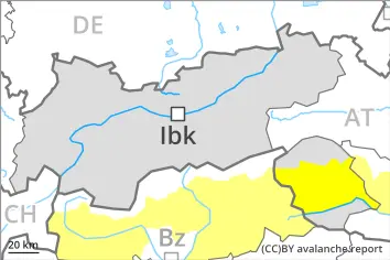
Increase in avalanche danger as a consequence of warming during the day and solar radiation. Weak layers in the upper part of the snowpack can be released in some places by people.
As a consequence of warming during the day and the solar radiation, the likelihood of moist and wet avalanches being released will increase. Avalanches can in particular be released in near-surface layers and reach medium size. This applies in all aspects in particular below approximately 2400 m, also on very steep sunny slopes in particular at elevated altitudes.
Avalanche prone locations for dry avalanches are to be found also on very steep west, north and east facing slopes above approximately 2400 m. The avalanche prone locations are difficult to recognise. Whumpfing sounds and the formation of shooting cracks when stepping on the snowpack can indicate the danger.
Avalanches can in isolated cases penetrate near-ground layers of the snowpack and reach large size.
Snowpack
dp.10: springtime scenario dp.4: cold following warm / warm following cold
Outgoing longwave radiation during the night will be quite good. The surface of the snowpack has frozen to form a strong crust only at high altitudes and will already soften in the late morning. The snowpack will become increasingly wet all the way through. This applies in all aspects at low and intermediate altitudes, as well as on steep sunny slopes at elevated altitudes.
Isolated avalanche prone weak layers exist in the top section of the old snowpack, especially on west, north and northeast facing slopes between approximately 2200 and 2800 m, and on sunny slopes in high Alpine regions.
Towards its base, the snowpack consists of faceted crystals, in particular on west, north and east facing slopes at elevated altitudes.
Tendency
Outgoing longwave radiation during the night will be good over a wide area. The avalanche danger will increase during the day.
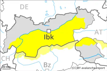
EARLIER Danger level
2400m
Avalanche Problem
Persistent weak layer
2400m
Wet snow
2400m
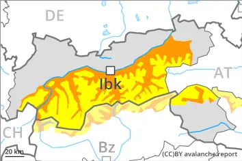
LATER Danger level
2400m
Avalanche Problem
Persistent weak layer
2400m
Wet snow
2400m
Increase in avalanche danger as a consequence of warming during the day and solar radiation. Weak layers in the upper part of the snowpack can be released in some places by people.
As a consequence of warming during the day and the solar radiation, the likelihood of moist and wet avalanches being released will increase. Avalanches can in particular be released in near-surface layers and reach medium size. This applies in all aspects in particular below approximately 2400 m, also on very steep sunny slopes in particular at elevated altitudes. In addition individual small to medium-sized gliding avalanches are possible. Avalanche prone locations for dry avalanches are to be found also on very steep west, north and east facing slopes above approximately 2400 m. The avalanche prone locations are difficult to recognise. Whumpfing sounds and the formation of shooting cracks when stepping on the snowpack can indicate the danger.
Avalanches can in isolated cases penetrate near-ground layers of the snowpack and reach large size.
Snowpack
dp.10: springtime scenario dp.4: cold following warm / warm following cold
Outgoing longwave radiation during the night will be quite good. The surface of the snowpack has frozen to form a strong crust only at high altitudes and will already soften in the late morning. The snowpack will become increasingly wet all the way through. This applies in all aspects at low and intermediate altitudes, as well as on steep sunny slopes at elevated altitudes.
Isolated avalanche prone weak layers exist in the top section of the old snowpack, especially on west, north and northeast facing slopes between approximately 2200 and 2800 m, and on sunny slopes in high Alpine regions.
Towards its base, the snowpack consists of faceted crystals, in particular on west, north and east facing slopes at elevated altitudes.
Tendency
Outgoing longwave radiation during the night will be good over a wide area. The avalanche danger will increase during the day.
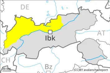
EARLIER Danger level
Avalanche Problem
Wet snow
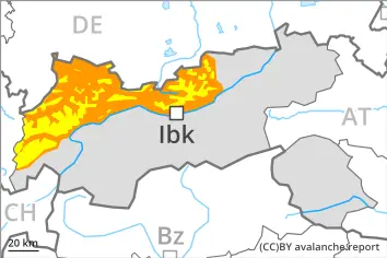
LATER Danger level
Avalanche Problem
Wet snow
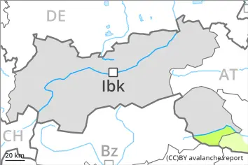
Increase in avalanche danger as a consequence of warming during the day and solar radiation.
As a consequence of warming during the day and the solar radiation, the likelihood of moist and wet avalanches being released will increase. This applies in all aspects in particular below approximately 2400 m. Avalanches can in particular be released in near-surface layers and reach medium size.
(--), caution is to be exercised, including on very steep shady slopes at elevated altitudes. These avalanche prone locations are rare and are difficult to recognise.
Snowpack
dp.10: springtime scenario dp.4: cold following warm / warm following cold
Outgoing longwave radiation during the night will be quite good. The surface of the snowpack has frozen to form a strong crust only at high altitudes and will already soften in the late morning. The snowpack will become increasingly wet all the way through. This applies in all aspects at low and intermediate altitudes, as well as on steep sunny slopes at elevated altitudes.
Towards its base, the snowpack consists of faceted crystals, especially on shady slopes at elevated altitudes.
Tendency
Outgoing longwave radiation during the night will be good over a wide area. The avalanche danger will increase a little during the day.
EARLIER Danger level
2000m
Avalanche Problem
Persistent weak layer
2000m
LATER Danger level
2000m
Avalanche Problem
Persistent weak layer
2000m
Wet snow
2800m
Gradual increase in avalanche danger as a consequence of warming during the day and solar radiation. Weak layers in the upper part of the snowpack can be released in some places by people.
A clear night will be followed in the early morning by quite favourable conditions mostly. Some small to medium-sized gliding avalanches are possible. As a consequence of warming during the day and the solar radiation, the likelihood of dry and moist avalanches being released will increase gradually. Avalanches can in particular be released in near-surface layers and reach medium size. Avalanche prone locations are to be found in particular on very steep west, north and east facing slopes between approximately 2000 and 2800 m. The avalanche prone locations are difficult to recognise. Whumpfing sounds and the formation of shooting cracks when stepping on the snowpack can indicate the danger. Avalanches can in isolated cases penetrate near-ground layers of the snowpack and reach large size.
Snowpack
dp.10: springtime scenario dp.4: cold following warm / warm following cold
Outgoing longwave radiation during the night will be quite good over a wide area. The surface of the snowpack will freeze to form a strong crust and will soften during the day. Isolated avalanche prone weak layers exist in the top section of the old snowpack, especially on west, north and northeast facing slopes between approximately 2000 and 2800 m, and on sunny slopes in high Alpine regions. Towards its base, the snowpack consists of faceted crystals, in particular on west, north and east facing slopes at elevated altitudes.
Tendency
Outgoing longwave radiation during the night will be good over a wide area. The avalanche danger will increase a little during the day.
EARLIER Danger level
2400m
Avalanche Problem
Persistent weak layer
2400m
LATER Danger level
2400m
Avalanche Problem
Persistent weak layer
2400m
Wet snow
2400m
Increase in avalanche danger as a consequence of warming during the day and solar radiation. Weak layers in the old snowpack can still be released in isolated cases.
As a consequence of warming during the day and the solar radiation, the likelihood of wet avalanches being released will increase. This applies in all aspects below approximately 2400 m, and on south facing slopes also at elevated altitudes. Wet avalanches can occur in particular in starting zones where previous releases have taken place. Sometimes avalanches are medium-sized and can be released easily also by a single winter sport participant.
In isolated cases dry avalanches can also be released in the old snowpack, this applies in case of a single winter sport participant. These avalanche prone locations are to be found in particular on very steep west, north and east facing slopes above approximately 2400 m. Especially transitions from a shallow to a deep snowpack are unfavourable. Avalanches can penetrate down to the ground and reach medium size.
Restraint should be exercised because avalanches can sweep people along and give rise to falls.
Snowpack
dp.7: snow-poor zones in snow-rich surrounding dp.10: springtime scenario
Outgoing longwave radiation during the night will be quite good in some case. The surface of the snowpack will only just freeze and will already soften in the late morning. Sunshine and high temperatures will give rise to increasing and thorough wetting of the snowpack.
The old wind slabs are lying on top of a weakly bonded old snowpack in particular on west, north and east facing slopes above approximately 2200 m. The snowpack will be subject to considerable local variations.
On steep sunny slopes at low and intermediate altitudes hardly any snow is lying.
Tendency
The avalanche danger will increase during the day.
EARLIER Danger level
LATER Danger level
2400m
Avalanche Problem
Wet snow
2400m
As the day progresses the likelihood of wet avalanches being released will increase a little.
The avalanche conditions in the morning, after a clear night, are mostly favourable. As the day progresses the likelihood of wet avalanches being released will increase. This applies in all aspects below approximately 2400 m, as well as on south facing slopes at elevated altitudes. Wet avalanches can occur in particular in starting zones where previous releases have taken place. Mostly these are small but can be released easily also by a single winter sport participant.
Restraint should be exercised because avalanches can sweep people along and give rise to falls.
Snowpack
dp.10: springtime scenario dp.1: deep persistent weak layer
Outgoing longwave radiation during the night will be quite good. The surface of the snowpack will only just freeze and will soften during the day. Sunshine and high temperatures will give rise to increasing and thorough wetting of the snowpack.
Rather lightly snow-covered west, north and east facing slopes above approximately 2400 m: Towards its base, the snowpack is faceted.
On steep sunny slopes at low and intermediate altitudes hardly any snow is lying.
Tendency
As the day progresses the likelihood of wet avalanches being released will increase a little.