The danger of wet avalanches will already increase in the late morning. Weak layers in the old snowpack can be released in some places by individual winter sport participants.
In the late morning as a consequence of warming during the day and solar radiation there will be a rapid increase in the danger of moist and wet avalanches. Avalanches can penetrate deep layers and reach large size in isolated cases. This applies in all aspects in particular below approximately 2400 m, as well as on very steep west, south and east facing slopes between approximately 2400 and 2800 m.
Avalanche prone locations for dry avalanches are to be found on very steep shady slopes above approximately 2400 m. The avalanche prone locations are difficult to recognise. Whumpfing sounds and the formation of shooting cracks when stepping on the snowpack can indicate the danger.
In steep terrain there is a danger of falling on the hard snow surface.
Snowpack
dp.10: springtime scenario dp.1: deep persistent weak layer
Outgoing longwave radiation during the night will be good. The surface of the snowpack has frozen to form a strong crust only at high altitudes and will already soften in the late morning. The snowpack will become increasingly wet all the way through. This applies in all aspects below approximately 2400 m, as well as on steep sunny slopes between approximately 2400 and 2800 m.
Isolated avalanche prone weak layers exist in the top section of the old snowpack. Towards its base, the snowpack consists of faceted crystals. This applies in particular on west, north and east facing slopes above approximately 2200 m, as well as on steep sunny slopes in high Alpine regions.
Tendency
Outgoing longwave radiation during the night will be good over a wide area. The avalanche danger will increase during the day.
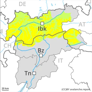
EARLIER Danger level
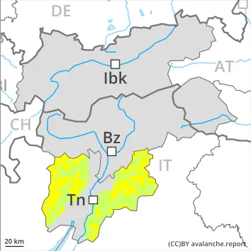
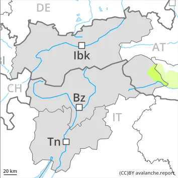
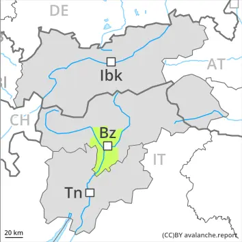
2400m
Avalanche Problem
Persistent weak layer
2400m
Wet snow
2400m
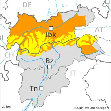
LATER Danger level
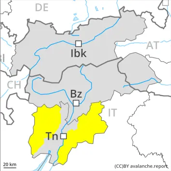
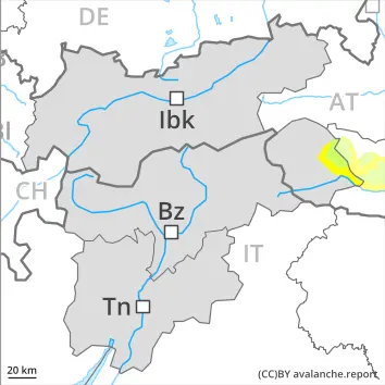
2600m
Avalanche Problem
Wet snow
2600m
Persistent weak layer
2400m
The danger of wet avalanches will already increase in the late morning. Weak layers in the old snowpack can still be released in isolated cases.
In the late morning as a consequence of warming during the day and solar radiation there will be a rapid increase in the danger of moist and wet avalanches. Avalanches can penetrate deep layers and reach medium size. This applies in all aspects in particular below approximately 2600 m, also on very steep sunny slopes at elevated altitudes.
Avalanche prone locations for dry avalanches are to be found in particular on very steep west, north and east facing slopes above approximately 2400 m. The avalanche prone locations are difficult to recognise. Especially transitions from a shallow to a deep snowpack are unfavourable.
In steep terrain there is a danger of falling on the hard snow surface.
Snowpack
dp.10: springtime scenario dp.1: deep persistent weak layer
Outgoing longwave radiation during the night will be good. The surface of the snowpack has frozen to form a strong crust only at high altitudes and will already soften in the late morning. Sunshine and high temperatures will give rise to increasing and thorough wetting of the snowpack. This applies in all aspects below approximately 2600 m, as well as on steep sunny slopes at elevated altitudes.
The old wind slabs are lying on top of a weakly bonded old snowpack in particular on west, north and east facing slopes above approximately 2400 m. The snowpack will be subject to considerable local variations.
On steep sunny slopes at low and intermediate altitudes hardly any snow is lying.
Tendency
Outgoing longwave radiation during the night will be good over a wide area. The avalanche danger will increase during the day.
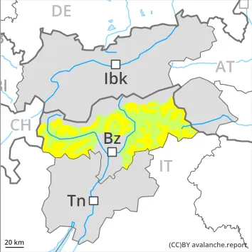
EARLIER Danger level
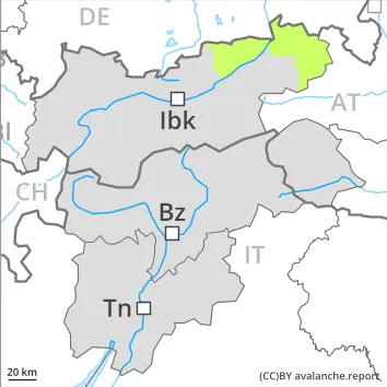
2000m
Avalanche Problem
Persistent weak layer
2000m
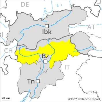
LATER Danger level
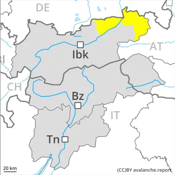
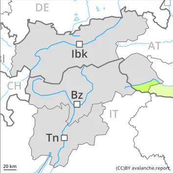
2000m
Avalanche Problem
Persistent weak layer
2000m
Wet snow
2800m
As the day progresses the likelihood of wet avalanches being released will increase quickly. Weakly bonded old snow requires caution.
Dry avalanches can be released in the old snowpack, this applies even in case of a single winter sport participant in some cases. They can penetrate down to the ground and reach medium size. Caution is to be exercised in particular on very steep west, north and east facing slopes above approximately 2000 m, and on south facing slopes in high Alpine regions. Especially transitions from a shallow to a deep snowpack are unfavourable. Avalanche prone locations are to be found in particular in gullies and bowls, and behind abrupt changes in the terrain.
As a consequence of warming during the day and the solar radiation, the likelihood of wet avalanches being released will increase. As the day progresses the likelihood of avalanches being released will increase especially on extremely steep sunny slopes. This applies in all aspects below approximately 2400 m, and on south facing slopes also at high altitude. Wet avalanches can occur in particular in starting zones where previous releases have taken place. In some cases these are medium-sized and can be released easily also by a single winter sport participant.
Backcountry tours should be concluded early.
Snowpack
dp.1: deep persistent weak layer dp.10: springtime scenario
Hard wind slabs are lying on top of a weakly bonded old snowpack in particular on west, north and east facing slopes at high altitudes and in high Alpine regions. The snowpack will be subject to considerable local variations.
Outgoing longwave radiation during the night was quite good over a wide area. The surface of the snowpack has frozen to form a strong crust only at high altitudes and will soften during the day. Sunshine and high temperatures will give rise as the day progresses to increasing and thorough wetting of the snowpack. On very steep sunny slopes and at the base of rock walls the snowpack will soften rapidly.
On sunny slopes at low and intermediate altitudes hardly any snow is lying.
Tendency
The avalanche danger will persist.
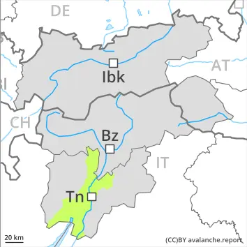
EARLIER Danger level
Avalanche Problem
Wet snow
LATER Danger level
Avalanche Problem
Wet snow
Increase in avalanche danger as a consequence of warming during the day and solar radiation.
As a consequence of warming during the day and the solar radiation, the likelihood of moist and wet avalanches being released will increase. This applies in all aspects in particular below approximately 2400 m, as well as on very steep sunny slopes at elevated altitudes.
Individual avalanche prone locations for dry avalanches are to be found on very steep shady slopes above approximately 2400 m. These avalanche prone locations are rare and are difficult to recognise.
In steep terrain there is a danger of falling on the hard snow surface.
Snowpack
dp.10: springtime scenario dp.1: deep persistent weak layer
Outgoing longwave radiation during the night will be good. The surface of the snowpack has frozen to form a strong crust only at high altitudes and will already soften in the late morning. The snowpack will become increasingly wet all the way through. This applies in all aspects at low and intermediate altitudes, as well as on steep sunny slopes at elevated altitudes.
Towards its base, the snowpack consists of faceted crystals, especially on shady slopes at elevated altitudes.
Tendency
Outgoing longwave radiation during the night will be good over a wide area. The avalanche danger will increase a little during the day.
EARLIER Danger level
2400m
Avalanche Problem
Persistent weak layer
2400m
LATER Danger level
2400m
Avalanche Problem
Persistent weak layer
2400m
Wet snow
2400m
Increase in avalanche danger as a consequence of warming during the day and solar radiation. Weak layers in the old snowpack can still be released in very isolated cases.
The avalanche conditions in the morning are mostly favourable. As a consequence of warming during the day and the solar radiation, the likelihood of wet avalanches being released will increase. This applies in all aspects below approximately 2400 m, and on south facing slopes at elevated altitudes. Sometimes avalanches are medium-sized and can be released also by a single winter sport participant.
In very isolated cases dry avalanches can also be released in the old snowpack. Avalanche prone locations are to be found in particular on very steep west, north and east facing slopes above approximately 2400 m. Avalanches can reach medium size.
Restraint should be exercised because avalanches can sweep people along and give rise to falls.
Snowpack
dp.7: snow-poor zones in snow-rich surrounding dp.10: springtime scenario
Outgoing longwave radiation during the night will be quite good at times. The surface of the snowpack will freeze to form a strong crust and will already soften in the late morning. Sunshine and high temperatures will give rise to increasing and thorough wetting of the snowpack.
The old wind slabs are lying on top of a weakly bonded old snowpack in particular on west, north and east facing slopes above approximately 2400 m.
Tendency
The avalanche danger will increase during the day.
EARLIER Danger level
LATER Danger level
Avalanche Problem
Wet snow
As the day progresses the likelihood of wet avalanches being released will increase a little.
The avalanche conditions in the morning are mostly favourable. As the day progresses the likelihood of wet avalanches being released will increase. This applies in all aspects. Avalanches are rather small but can be released also by a single winter sport participant.
Restraint should be exercised because avalanches can sweep people along and give rise to falls.
Snowpack
dp.10: springtime scenario dp.1: deep persistent weak layer
Outgoing longwave radiation during the night will be quite good at times. The surface of the snowpack will freeze to form a strong crust and will already soften in the late morning. Sunshine and high temperatures will give rise to increasing and thorough wetting of the snowpack.
Tendency
As the day progresses the likelihood of wet avalanches being released will increase a little.
Danger level
Low danger will prevail.
Avalanches can in very isolated cases penetrate near-ground layers of the snowpack and reach medium size in isolated cases. As the day progresses the likelihood of wet avalanches being released will increase.
Snowpack
dp.10: springtime scenario
Thus far the weather has been mild over a wide area. Sunshine and high temperatures will give rise as the day progresses to rapid moistening of the snowpack.
The snowpack will be subject to considerable local variations. In particular on sunny slopes at low and intermediate altitudes only a little snow is lying.
Tendency
The avalanche danger will persist.
Danger level
Low avalanche danger will prevail.
As the day progresses the likelihood of wet avalanches being released will increase especially on extremely steep east and west facing slopes. Avalanches can in very isolated cases penetrate deep layers and reach medium size in isolated cases. In steep terrain there is a danger of falling on the hard snow surface.
Snowpack
dp.10: springtime scenario
The snowpack will be subject to considerable local variations. In particular on steep sunny slopes at low and intermediate altitudes hardly any snow is lying. Sunshine and high temperatures will give rise to increasing and thorough wetting of the snowpack.