The danger of moist and wet avalanches will increase quickly in the early morning.
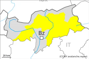
The danger of moist and wet avalanches will already be elevated in the early morning. In the late morning as a consequence of warming during the day and solar radiation there will be an increase in the danger within the current danger level. Avalanches can penetrate deep layers and reach medium size. This applies in all aspects below approximately 2400 m, as well as on very steep sunny slopes below approximately 3000 m.
Avalanche prone locations for dry avalanches are to be found on very steep shady slopes above approximately 2400 m. The avalanche prone locations are difficult to recognise. Especially transitions from a shallow to a deep snowpack are unfavourable.
Snowpack
dp.10: springtime scenario dp.1: deep persistent weak layer
Outgoing longwave radiation during the night will be reduced. The surface of the snowpack will freeze very little and will already soften in the late morning. The snowpack will become increasingly wet all the way through. This applies in all aspects below approximately 2400 m, as well as on steep sunny slopes at high altitude.
Towards its base, the snowpack consists of faceted crystals. This applies in particular on west, north and east facing slopes at high altitude, as well as in all aspects in high Alpine regions. The snowpack will be subject to considerable local variations.
On steep sunny slopes at low and intermediate altitudes hardly any snow is lying.
Tendency
As a consequence of mild temperatures and very cloudy skies the snowpack can not consolidate during the night. Up to high altitudes rain will fall on Monday. As a consequence of the rain, the likelihood of wet avalanches being released will increase in particular on steep shady slopes below approximately 2500 m.
Danger level
3000m
Avalanche Problem
Wet snow
3000m
Persistent weak layer
2400m
The danger of moist and wet avalanches will already be elevated in the early morning.
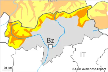
The danger of moist and wet avalanches will already be elevated in the early morning. As the day progresses as a consequence of warming during the day and solar radiation there will be an additional increase in the danger. This applies in all aspects below approximately 2400 m, as well as on very steep sunny slopes below approximately 3000 m. Avalanches can penetrate deep layers and reach large size.
Individual avalanche prone locations for dry avalanches are to be found on very steep shady slopes above approximately 2400 m. Such avalanche prone locations are difficult to recognise. Especially transitions from a shallow to a deep snowpack are unfavourable.
In addition the fresh wind slabs in high Alpine regions are prone to triggering in some cases, especially adjacent to ridgelines on very steep shady slopes. Wind slabs are mostly small.
Snowpack
dp.10: springtime scenario dp.1: deep persistent weak layer
The surface of the snowpack will cool hardly at all during the overcast night. Sunshine and high temperatures will give rise as the day progresses to increasing and thorough wetting of the snowpack. This applies in all aspects below approximately 2400 m, as well as on sunny slopes at elevated altitudes.
Isolated avalanche prone weak layers exist in the top section of the old snowpack. Towards its base, the snowpack consists of faceted crystals. This applies in particular on west, north and east facing slopes at high altitude, as well as in all aspects in high Alpine regions.
Tendency
As a consequence of mild temperatures and very cloudy skies the snowpack can not consolidate during the night. Up to high altitudes rain will fall on Monday in particular in the south. As a consequence of the rain, the likelihood of wet avalanches being released will increase in particular on steep shady slopes below approximately 2500 m.
Danger level
Low avalanche danger will prevail.
As the day progresses the likelihood of wet avalanches being released will increase especially on extremely steep shady slopes. Avalanches can in very isolated cases penetrate deep layers and reach medium size in isolated cases.
Snowpack
dp.10: springtime scenario
The snowpack will be subject to considerable local variations. In particular on steep sunny slopes at low and intermediate altitudes hardly any snow is lying. Sunshine and high temperatures will give rise to increasing and thorough wetting of the snowpack.
Tendency
Low avalanche danger will prevail. As a consequence of mild temperatures very cloudy skies the snowpack can not consolidate during the night. Up to high altitudes rain will fall on Monday in some regions. The danger of moist and wet avalanches will persist.