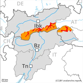
As a consequence of the rain natural wet avalanches are to be expected.
A dangerous avalanche situation will prevail. Wet snow represents the main danger.
As a consequence of the rain, the likelihood of wet avalanches being released will increase in particular below approximately 2500 m, especially on steep west, north and east facing slopes. In these regions natural avalanches are to be expected, even large ones.
Dry and wet avalanches can additionally in some places be released, even by a single winter sport participant. This applies on steep west, north and east facing slopes above approximately 2500 m. Avalanches can be triggered in deep layers and reach large size.
In addition the fresh wind slabs in high Alpine regions are capable of being triggered in some cases, in particular on near-ridge shady slopes.
Snowpack
dp.3: rain dp.1: deep persistent weak layer
The surface of the snowpack will cool hardly at all during the overcast night and will already be soft in the early morning. Up to 2500 m rain will fall. The rain will give rise to a loss of strength within the snowpack especially on steep shady slopes.
10 to 20 cm of snow, and even more in some localities, will fall above approximately 2500 m. As a consequence of a strong wind, sometimes easily released wind slabs will form in high Alpine regions.
Steep west, north and east facing slopes above approximately 2500 m: Isolated avalanche prone weak layers exist in the top section of the old snowpack. Faceted weak layers exist in the bottom section of the old snowpack.
Tendency
Decrease in danger of wet avalanches as the snowfall level drops. Above approximately 2000 m snow will fall in some regions.
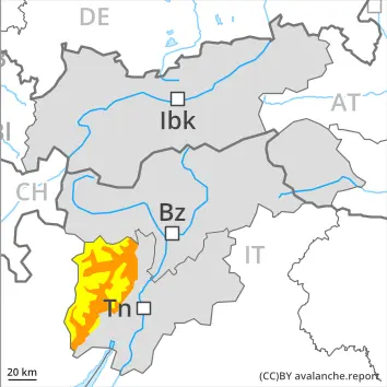
Danger level
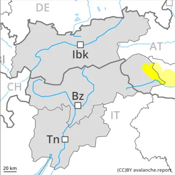
2800m
Avalanche Problem
Wet snow
2800m
Persistent weak layer
2500m
Wet snow represents the main danger. As a consequence of the rain natural wet avalanches are to be expected.
As a consequence of the rain, the likelihood of wet avalanches being released will increase in particular on steep shady slopes below approximately 2500 m. In these regions natural avalanches are to be expected, even large ones. Moist and wet avalanches can additionally in some places be released, even by a single winter sport participant, this also applies on steep west, north and east facing slopes below approximately 2800 m.
Individual avalanche prone locations for dry avalanches are to be found on very steep shady slopes above approximately 2500 m. In addition the fresh wind slabs in high Alpine regions are capable of being triggered in isolated cases, in particular on near-ridge shady slopes. Wind slabs are mostly small.
Snowpack
dp.3: rain dp.1: deep persistent weak layer
The surface of the snowpack will cool hardly at all during the overcast night and will already be soft in the early morning. Up to 2500 m rain will fall. The rain will give rise to a loss of strength within the snowpack especially on steep shady slopes.
Steep west, north and east facing slopes above approximately 2500 m: Isolated avalanche prone weak layers exist in the top section of the old snowpack. Faceted weak layers exist in the bottom section of the old snowpack.
Above approximately 2500 m snow will fall. As a consequence of a strong wind, small wind slabs will form in high Alpine regions.
Tendency
Slight decrease in danger of wet avalanches as the snowfall level drops. Above approximately 2000 m snow will fall in some regions.
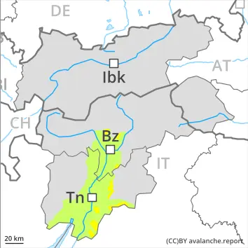
Danger level
2800m
Avalanche Problem
Wet snow
2800m
Wind slab
2800m
Persistent weak layer
2500m
As a consequence of the rain natural wet avalanches are to be expected.
Wet snow represents the main danger. Wind slabs in high Alpine regions.
As a consequence of the rain, the likelihood of wet avalanches being released will increase in particular below approximately 2500 m, especially on steep west, north and east facing slopes. In these regions natural avalanches are to be expected, even large ones. Moist and wet avalanches can additionally in some places be released, even by a single winter sport participant, this also applies on steep west, north and east facing slopes below approximately 2800 m.
Individual avalanche prone locations for dry avalanches are to be found on very steep shady slopes above approximately 2500 m. Such avalanche prone locations are difficult to recognise. Especially transitions from a shallow to a deep snowpack are unfavourable. In addition the fresh wind slabs in high Alpine regions are capable of being triggered in some cases, in particular on near-ridge shady slopes.
Snowpack
dp.3: rain dp.6: cold, loose snow and wind
The surface of the snowpack will cool hardly at all during the overcast night and will already be soft in the early morning. Up to 2500 m and above rain will fall. The rain will give rise to a loss of strength within the snowpack especially on steep shady slopes.
10 to 20 cm of snow, and even more in some localities, will fall above approximately 2500 m. As a consequence of a strong wind, sometimes easily released wind slabs will form in high Alpine regions.
Steep west, north and east facing slopes above approximately 2500 m: Isolated avalanche prone weak layers exist in the top section of the old snowpack. Faceted weak layers exist in the bottom section of the old snowpack.
Tendency
Slight decrease in danger of wet avalanches as the snowfall level drops. Above approximately 2000 m snow will fall in some regions.
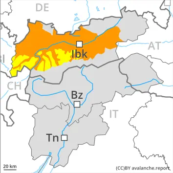
Danger level
2200m
Avalanche Problem
Wet snow
2200m
New snow
2200m
As a consequence of the rain, the likelihood of wet avalanches being released will increase.
As a consequence of the rain, the likelihood of wet avalanches being released will increase in particular below approximately 2200 m, especially on steep west, north and east facing slopes. In these regions natural avalanches are to be expected, even large ones in isolated cases.
In addition the fresh wind slabs in high Alpine regions are capable of being triggered in some cases, in particular on near-ridge slopes. The avalanche prone locations for dry avalanches are to be found on very steep shady slopes above approximately 2200 m. Such avalanche prone locations are difficult to recognise. Especially transitions from a shallow to a deep snowpack are unfavourable.
Snowpack
dp.3: rain dp.6: cold, loose snow and wind
Below approximately 1800 m only a little snow is lying. At higher altitudes there are 30 to 80 cm of snow, and even as much as 150 cm in some localities. The surface of the snowpack will cool hardly at all during the overcast night and will already be soft in the early morning. Up to 2200 m rain will fall. The rain will give rise to a loss of strength within the snowpack especially on steep shady slopes.
20 to 40 cm of snow, and even more in some localities, will fall above approximately 2200 m. As a consequence of a strong wind, sometimes easily released wind slabs will form in high Alpine regions.
Steep west, north and east facing slopes above approximately 2400 m: Large-grained weak layers exist in the bottom section of the old snowpack.
Tendency
Slight decrease in danger of wet avalanches as the snowfall level drops.
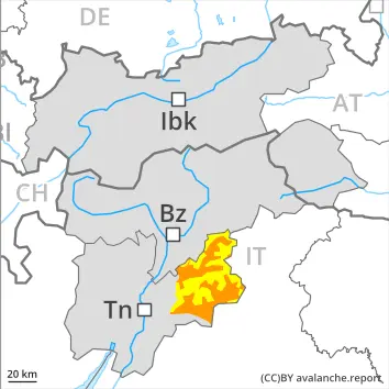
Danger level
2800m
Avalanche Problem
Wet snow
2800m
Persistent weak layer
2500m
The danger of moist and wet avalanches will already be elevated in the early morning.
The danger of moist and wet avalanches will already be elevated in the early morning. This applies on steep shady slopes below approximately 2500 m, as well as on very steep sunny slopes below approximately 2800 m. Wet avalanches can in some places be released by a single winter sport participant. Avalanches can penetrate deep layers and reach large size.
Individual avalanche prone locations for dry avalanches are to be found on very steep shady slopes above approximately 2500 m. Such avalanche prone locations are difficult to recognise. Especially transitions from a shallow to a deep snowpack are unfavourable.
Snowpack
dp.10: springtime scenario dp.1: deep persistent weak layer
The surface of the snowpack will cool hardly at all during the overcast night and will already be soft in the early morning. This applies in all aspects below approximately 2500 m, as well as on sunny slopes at elevated altitudes. The snowpack will be weakly bonded in some places.
Steep west, north and east facing slopes above approximately 2500 m: Isolated avalanche prone weak layers exist in the top section of the old snowpack. Towards its base, the snowpack consists of faceted crystals.
Tendency
Slight decrease in danger of wet avalanches as the temperature drops. Down to 2000 m snow will fall in some regions.
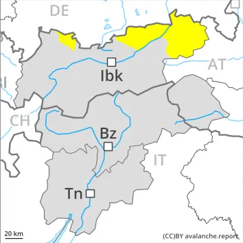
Danger level
2200m
Avalanche Problem
Wet snow
2200m
Persistent weak layer
2400m
Wet snow represents the main danger. As a consequence of the rain natural wet avalanches are to be expected.
As a consequence of the rain, the likelihood of wet avalanches being released will increase in particular on steep shady slopes below approximately 2200 m. In these regions natural avalanches are to be expected, even large ones.
Individual avalanche prone locations for dry avalanches are to be found on very steep shady slopes above approximately 2400 m. Such avalanche prone locations are difficult to recognise. Especially transitions from a shallow to a deep snowpack are unfavourable. In addition the fresh wind slabs in high Alpine regions are capable of being triggered in isolated cases, in particular on near-ridge shady slopes. Wind slabs are mostly small.
Snowpack
dp.3: rain dp.1: deep persistent weak layer
Below approximately 1800 m only a little snow is lying. At higher altitudes there are 30 to 80 cm of snow, and even as much as 150 cm in some localities. The surface of the snowpack will cool hardly at all during the overcast night and will already be soft in the early morning. The sleet will give rise to a loss of strength within the snowpack in some places below approximately 2200 m.
Steep west, north and east facing slopes above approximately 2200 m: Faceted weak layers exist in the bottom section of the old snowpack. Above approximately 2200 m snow will fall. As a consequence of a strong wind, small wind slabs will form in high Alpine regions.
Tendency
Slight decrease in danger of wet avalanches as the snowfall level drops. Above approximately 2000 m snow will fall in some regions.
Danger level
Avalanche Problem
Wet snow
Wet snow represents the main danger.
Wet avalanches can in some places be released by small loads, especially on very steep slopes. Avalanches can in very isolated cases penetrate near-ground layers of the snowpack and reach medium size, in particular on very steep shady slopes above approximately 2000 m.
Snowpack
dp.10: springtime scenario dp.1: deep persistent weak layer
The snowpack will be wet all the way through over a wide area. As a consequence of mild temperatures and high relative humidity the snowpack can not consolidate. The snowpack remains weakly bonded in some places. Towards its base, the snowpack consists of faceted crystals, especially on shady slopes at elevated altitudes.
Tendency
Slight decrease in danger of wet avalanches as the temperature drops. Down to 2000 m snow will fall in some regions.
Danger level
Avalanche Problem
Wet snow
Wet snow represents the main danger.
The danger of moist and wet avalanches will already exist in the early morning. This applies on very steep sunny slopes in particular below approximately 2800 m, as well as in all aspects below approximately 2500 m. As a consequence of the rain, the likelihood of avalanches being released will increase especially on steep shady slopes below approximately 2500 m. Avalanches can in isolated cases penetrate near-ground layers of the snowpack and reach medium size.
In very isolated cases dry avalanches can also be released in the old snowpack. Avalanche prone locations are to be found in particular on very steep shady slopes above approximately 2500 m.
Snowpack
dp.3: rain dp.1: deep persistent weak layer
Outgoing longwave radiation during the night will be severely restricted. The surface of the snowpack will freeze very little and will already be soft in the early morning.
Some rain will fall in some regions. These weather conditions will give rise to increasing and thorough wetting of the snowpack.
Faceted weak layers exist in the bottom section of the old snowpack, especially on steep west, north and east facing slopes above approximately 2500 m.
Tendency
The danger of wet avalanches will persist.
Danger level
Avalanche Problem
Wet snow
Wet snow requires caution.
As a consequence of the rain, the likelihood of wet avalanches being released will increase. This applies in all aspects. Avalanches are rather small but easily released. Avalanches can in isolated cases release deeper layers of the snowpack and reach medium size.
Snowpack
dp.3: rain dp.1: deep persistent weak layer
Outgoing longwave radiation during the night will be severely restricted. The surface of the snowpack will cool hardly at all during the overcast night and will already be soft in the early morning.
Some rain will fall. These weather conditions will give rise to increasing and thorough wetting of the snowpack.
Tendency
The danger of wet avalanches will persist.
Danger level
2000m
Avalanche Problem
Wet snow
2000m
Wet snow represents the main danger. As a consequence of the rain natural wet avalanches are to be expected.
The danger of moist and wet avalanches will already be elevated in the early morning. As a consequence of the rain, the likelihood of wet avalanches being released will increase in particular on steep shady slopes. Individual natural avalanches are to be expected, even medium-sized ones.
Snowpack
dp.10: springtime scenario dp.1: deep persistent weak layer
The surface of the snowpack will cool hardly at all during the overcast night and will already be soft in the early morning. Up to 2200 m and above rain will fall. The weather conditions towards the evening will give rise to increasing and thorough wetting of the snowpack. This situation will give rise to a loss of strength within the snowpack especially on steep shady slopes.
Tendency
Slight decrease in danger of wet avalanches as the snowfall level drops. Above approximately 2000 m snow will fall in some regions.