As a consequence of the rain more frequent wet avalanches are to be expected. This applies in particular on very steep shady slopes at high altitude. Avalanches can release the saturated snowpack and reach medium size. The runout zones of avalanches are to be avoided.
Snowpack
dp.3: rain dp.1: deep persistent weak layer
Up to 2500 m rain will fall.
Northwest, north and northeast facing slopes: The surface of the snowpack will cool hardly at all during the overcast night and will already be soft in the early morning. The rain will give rise to extreme and thorough wetting of the snowpack.
West and east facing slopes: The snowpack will be wet all the way through.
Tendency
Gradual decrease in danger of wet avalanches.
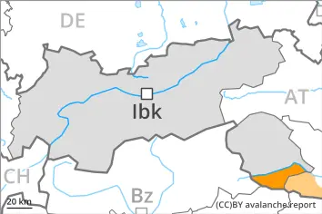
Danger level
2500m
Avalanche Problem
Wet snow
2500m
Wind slab
2500m
Persistent weak layer
2500m
As a consequence of the rain natural wet avalanches are possible.
Wet snow represents the main danger. Wind slabs in high Alpine regions.
The danger of wet avalanches will persist, especially on steep west, north and east facing slopes. In these regions natural avalanches are possible, even large ones. In steep gullies in particular in the regions with a lot of snow wet avalanches can in isolated cases reach areas without any snow cover. Moist and wet avalanches can additionally in some places be released, even by a single winter sport participant.
Avalanche prone locations for dry avalanches are to be found on very steep west, north and east facing slopes above approximately 2500 m. The fresh wind slabs can be released by a single winter sport participant, in particular adjacent to ridgelines and in gullies and bowls. Such avalanche prone locations are sometimes covered with new snow and are difficult to recognise. Especially transitions from a shallow to a deep snowpack are unfavourable. Avalanches can in very isolated cases penetrate deep layers reach large size.
Snowpack
dp.3: rain dp.6: cold, loose snow and wind
Up to 2500 m rain will fall. The rain will give rise to a loss of strength within the snowpack especially on steep shady slopes.
Up to 15 cm of snow, and even more in some localities, will fall above approximately 2500 m. As a consequence of a sometimes strong southeasterly wind, sometimes easily released wind slabs will form at elevated altitudes.
Steep west, north and east facing slopes above approximately 2500 m: Isolated avalanche prone weak layers exist in the top section of the old snowpack. Faceted weak layers exist in the bottom section of the old snowpack.
Tendency
The danger of moist and wet avalanches will persist. As a consequence of warming during the day and solar radiation more frequent natural avalanches are to be expected, in the regions exposed to a lot of new snow especially.
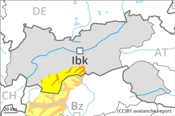
Danger level
2500m
Avalanche Problem
Wet snow
2500m
Persistent weak layer
2500m
The danger of moist and wet avalanches will persist.
Most and wet avalanches can in some places be released by a single winter sport participant. In addition further individual natural wet avalanches are possible. Caution is to be exercised in particular on very steep west, north and east facing slopes below approximately 2500 m. Avalanches can release the entire snowpack and reach large size in isolated cases.
Individual avalanche prone locations for dry avalanches are to be found on very steep shady slopes above approximately 2500 m. Such avalanche prone locations are difficult to recognise. Especially transitions from a shallow to a deep snowpack are unfavourable.
Snowpack
dp.10: springtime scenario dp.1: deep persistent weak layer
The snowpack is wet all the way through. This applies on steep sunny slopes below approximately 3000 m, as well as on steep shady slopes below approximately 2400 m. West, north and east facing slopes above approximately 2200 m: Towards its base, the snowpack consists of faceted crystals. The snowpack will be weakly bonded in some places.
The surface of the snowpack will cool hardly at all during the overcast night and will already be soft in the early morning. Up to 2200 m rain will fall. In some regions 5 to 10 cm of snow will fall above approximately 2200 m.
Tendency
The danger of moist and wet avalanches will persist. As a consequence of warming during the day and solar radiation more frequent natural avalanches are to be expected.
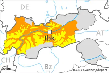
Danger level
2500m
Avalanche Problem
Wet snow
2500m
Persistent weak layer
2500m
Wet snow represents the main danger. As a consequence of the rain natural wet avalanches are possible.
The danger of wet avalanches will persist, especially on very steep west, north and east facing slopes below approximately 2500 m. In these regions natural avalanches are possible, even large ones in isolated cases. In steep gullies especially in the regions with a lot of snow wet avalanches can in isolated cases reach areas without any snow cover. Moist and wet avalanches can additionally in some places be released, even by a single winter sport participant.
Individual avalanche prone locations for dry avalanches are to be found on very steep shady slopes above approximately 2500 m. Such avalanche prone locations are difficult to recognise. In addition the fresh wind slabs in high Alpine regions are capable of being triggered in isolated cases, in particular on near-ridge shady slopes. Wind slabs are mostly small.
Snowpack
dp.3: rain dp.1: deep persistent weak layer
Up to 2500 m rain will fall. The rain will give rise to a loss of strength within the snowpack especially on steep shady slopes.
Steep west, north and east facing slopes above approximately 2500 m: Isolated avalanche prone weak layers exist in the top section of the old snowpack. Faceted weak layers exist in the bottom section of the old snowpack.
Above approximately 2500 m snow will fall. As a consequence of a sometimes strong southeasterly wind, small wind slabs formed in high Alpine regions.
Tendency
The danger of wet avalanches will persist.
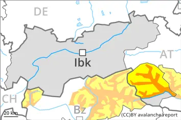
Danger level
Avalanche Problem
Wet snow
Wet snow represents the main danger.
Wet avalanches can in some places be released by small loads, especially on very steep west, north and east facing slopes. As a consequence of the rain individual natural avalanches are possible. Avalanches can in very isolated cases release the saturated snowpack and reach medium size, in particular on very steep shady slopes above approximately 2000 m.
Snowpack
dp.10: springtime scenario dp.1: deep persistent weak layer
The snowpack will be wet all the way through over a wide area. Up to 2200 m rain will fall. The snowpack will be weakly bonded in particular on very steep shady slopes. Isolated avalanche prone weak layers exist in the bottom section of the snowpack. On steep sunny slopes only a little snow is now lying.