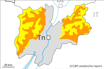
Wet snow at intermediate altitudes. Wind slabs and weakly bonded old snow in the high Alpine regions.
As a consequence of the rain, the likelihood of wet avalanches being released will increase in particular on steep shady slopes below approximately 2200 m. From origins in starting zones where no previous releases have taken place natural avalanches are possible, even large ones.
Individual avalanche prone locations for dry avalanches are to be found on very steep shady slopes above approximately 2200 m. Such avalanche prone locations are difficult to recognise. Especially transitions from a shallow to a deep snowpack are unfavourable.
In addition the fresh wind slabs in high Alpine regions are capable of being triggered in isolated cases. Wind slabs are mostly small.
Snowpack
dp.3: rain dp.1: deep persistent weak layer
Above approximately 2000 m snow has fallen over a wide area. Below approximately 1800 m from a snow sport perspective, in most cases insufficient snow is lying. At higher altitudes there are 30 to 80 cm of snow, and even as much as 150 cm in some localities.
The surface of the snowpack will cool hardly at all during the overcast night and will already be soft in the early morning. The rain will give rise to increasing moistening of the snowpack below approximately 2200 m. As a consequence of a strong wind, small wind slabs will form in high Alpine regions.
Steep west, north and east facing slopes above approximately 2200 m: Faceted weak layers exist in the bottom section of the old snowpack.
Tendency
On Wednesday it will be mostly sunny. Decrease in danger of wet avalanches as a consequence of the ceasing of precipitation.
Danger level
2000m
Avalanche Problem
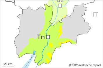
Wet snow
2000m
Wet snow represents the main danger. As a consequence of the rain natural wet avalanches are possible.
The danger of moist and wet avalanches will already be elevated in the early morning. As a consequence of the rain, the likelihood of wet avalanches being released will increase in particular on steep shady slopes. Only isolated natural avalanches are possible, even medium-sized ones.
Snowpack
dp.10: springtime scenario dp.1: deep persistent weak layer
The surface of the snowpack will freeze very little and will already be soft in the early morning. Up to high altitudes rain will fall. The rain will give rise to a loss of strength within the snowpack especially on steep shady slopes.
Tendency
Decrease in danger of wet avalanches as the precipitation eases.