Danger level
 | 2900m |
|  |
|  | ||||
|  |
|  |


![]()
Increase in danger of wet avalanches in the course of the day.
As a consequence of warming during the day and solar radiation there will be an increase in the danger of wet avalanches.
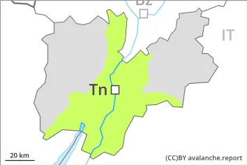
From origins in starting zones where no previous releases have taken place natural avalanches are possible, in particular medium-sized ones. This applies on shady slopes below approximately 2900 m, as well as on sunny slopes at elevated altitudes. On steep shady slopes avalanches can be released in the weakly bonded old snow and reach large size in isolated cases.
Individual avalanche prone locations for dry avalanches are to be found on very steep shady slopes above approximately 2400 m. Such avalanche prone locations are difficult to recognise.
Backcountry tours and off-piste skiing should be started and concluded early.
Snowpack
dp.10: springtime scenario
dp.1: deep persistent weak layer
Some rain will fall in the afternoon in some regions. The surface of the snowpack will freeze to form a strong crust only at high altitudes and will already soften in the late morning. Sunshine and high temperatures will give rise to increasing and thorough wetting of the snowpack below approximately 2900 m. The high humditiy will give rise in the afternoon to a loss of strength within the snowpack also on steep shady slopes.
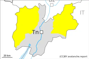
Steep west, north and east facing slopes above approximately 2400 m: Faceted weak layers exist in the bottom section of the old snowpack.
Below approximately 1800 m from a snow sport perspective, in most cases insufficient snow is lying.
Tendency
Wet snow requires caution. As the day progresses as a consequence of warming during the day there will be an increase in the danger of wet avalanches. Some rain will fall in some regions.