Wet avalanches can in isolated cases be released by a single winter sport participant. This applies especially below approximately 2600 m.
As a consequence of new snow and a moderate wind, clearly visible wind slabs will form in particular in high Alpine regions. These are small and can only be released in isolated cases.
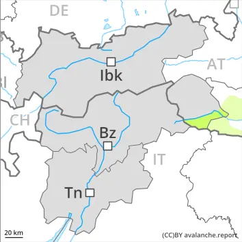
Weak layers in the old snowpack can be released in isolated cases and mostly by large additional loads in particular on very steep shady slopes, in particular above approximately 2500 m.
Snowpack
dp.3: rain dp.1: deep persistent weak layer
Outgoing longwave radiation during the night will be severely restricted at times. The surface of the snowpack will freeze very little and will soften quickly. Some rain will fall in the afternoon in some regions.
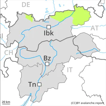
Shady slopes above approximately 2500 m: Faceted weak layers exist in the bottom section of the old snowpack at elevated altitudes.
On steep sunny slopes as well as below approximately 1800 m hardly any snow is lying.
Tendency
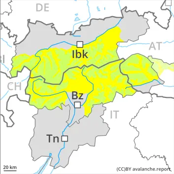
Up to 2600 m rain will fall in some regions. The danger of wet avalanches will already exist in the early morning.
Danger level
2800m
Avalanche Problem
Wet snow
2800m
Persistent weak layer
2500m
Increase in danger of wet avalanches in the course of the day.
As a consequence of new snow and wind, wind slabs will form in particular in high Alpine regions. On very steep slopes the moist avalanches can be released naturally and reach medium size in isolated cases. As a consequence of warming there will be an increase in the avalanche danger. Individual avalanche prone locations are to be found on very steep shady slopes above approximately 2500 m. Avalanches can be released, mostly by large loads and reach medium size. In very isolated cases these can penetrate down to the ground and reach large size.
Snowpack
dp.10: springtime scenario dp.1: deep persistent weak layer
The surface of the snowpack will only just freeze and will soften quickly. In some regions 5 to 15 cm of snow will fall above approximately 2400 m. The spring-like weather conditions will give rise to rapid moistening of the snowpack below approximately 2800 m. Steep west, north and east facing slopes above approximately 2500 m: Faceted weak layers exist in the bottom section of the old snowpack.
Tendency
During the day: The avalanche danger will increase but remain within the current danger level.
Danger level
2600m
Avalanche Problem
Wet snow
2600m
Wet snow requires caution.
Wet avalanches can in isolated cases be released by a single winter sport participant. This applies especially below approximately 2600 m.
Snowpack
dp.10: springtime scenario dp.1: deep persistent weak layer
Outgoing longwave radiation during the night will be severely restricted at times. The surface of the snowpack will freeze very little and will soften quickly.
Shady slopes above approximately 2500 m: Faceted weak layers exist in the bottom section of the old snowpack at elevated altitudes.
On steep sunny slopes as well as below approximately 1800 m hardly any snow is lying.
Tendency
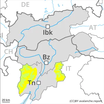
Some rain will fall over a wide area. The danger of wet avalanches will already exist in the early morning.
Danger level
Wet snow requires caution.
Only isolated wet avalanches are possible. Caution is to be exercised on extremely steep shady slopes. Mostly avalanches are rather small.
Snowpack
dp.3: rain dp.10: springtime scenario
Outgoing longwave radiation during the night will be severely restricted. The surface of the snowpack will freeze very little and will soften quickly. Some rain will fall in the afternoon.
Tendency
Low avalanche danger will prevail. Wet snow requires caution.
Danger level
Wet snow requires caution.
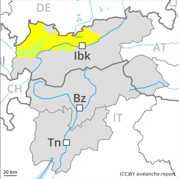
The surface of the snowpack will cool hardly at all during the overcast night will already be soft in the early morning. As a consequence of the rain, the likelihood of wet avalanches being released will increase a little. This applies in particular on extremely steep shady slopes. Mostly avalanches are small.
Snowpack
dp.10: springtime scenario
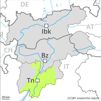
The snowpack will be wet all the way through over a wide area. The surface of the snowpack will freeze very little and will already be soft in the early morning. At low and intermediate altitudes hardly any snow is lying.
Tendency
Low avalanche danger will prevail.
Danger level
Avalanche Problem
Wet snow
Low avalanche danger will prevail.
From origins in starting zones where no previous releases have taken place only isolated wet avalanches are possible. Caution is to be exercised on extremely steep shady slopes. Mostly avalanches are rather small.
Snowpack
dp.10: springtime scenario
Little snow will fall in some regions. Outgoing longwave radiation during the night will be reduced over a wide area. The surface of the snowpack has frozen to form a strong crust only at high altitudes and will soften quickly.
Tendency
Low avalanche danger will prevail.
Danger level
Avalanche Problem
Wet snow
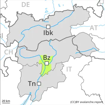
Individual avalanche prone locations for wet avalanches are to be found in particular on extremely steep shady slopes.
Only isolated wet avalanches are possible. This applies in particular on extremely steep shady slopes. Mostly avalanches are small.
Snowpack
dp.3: rain
The snowpack will be wet all the way through over a wide area. The surface of the snowpack will freeze very little and will soften quickly. Some rain will fall in the afternoon in some regions. On steep sunny slopes as well as below approximately 1800 m hardly any snow is lying.
Tendency
Some rain will fall over a wide area. Wet snow requires caution.