EARLIER
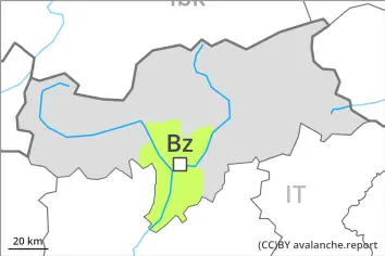
Danger level
 |
LATER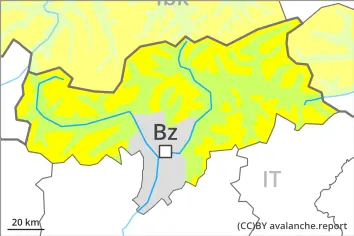
Danger level
 | 2500m |
|  |
|  |

Increase in danger of wet avalanches in the course of the day.
As the day progresses as a consequence of warming during the day and solar radiation there will be a gradual increase in the danger of wet avalanches. Wet avalanches can be released by a single winter sport participant, especially on very steep sunny slopes above approximately 2500 m, this also applies on very steep shady slopes below approximately 2500 m in gullies and bowls. In isolated cases avalanches are medium-sized.
Weak layers in the old snowpack can be released in isolated cases and mostly by large additional loads in particular on very steep shady slopes, in particular above approximately 2500 m.
Snowpack
dp.10: springtime scenario
dp.1: deep persistent weak layer
Outgoing longwave radiation during the night will be good over a wide area. The surface of the snowpack will freeze to form a strong crust and will soften during the day.
Shady slopes above approximately 2500 m: Faceted weak layers exist in the bottom section of the old snowpack at elevated altitudes.
Below approximately 2000 m no snow is lying. Between approximately 2000 and 2500 m only a little snow is now lying, in particular on very steep shady slopes in gullies and bowls.
Tendency
A clear night will be followed in the early morning by favourable conditions generally. Gradual increase in danger of wet avalanches as a consequence of warming during the day and solar radiation.