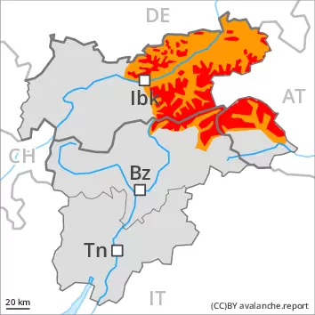
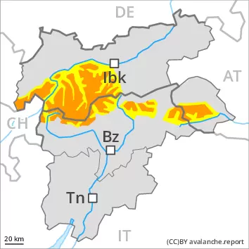
High avalanche danger will prevail. The conditions are critical for backcountry touring and other off-piste activities outside marked and open pistes.
Remotely triggered and natural avalanches are possible. The new snow and wind slabs can be released easily, even by a single winter sport participant, in all aspects. They are covered with new snow and are barely recognisable, even to the trained eye. At a distance from ridgelines the wind slabs are larger. Large avalanches are possible here. Additionally avalanches can also penetrate deep layers. Such avalanche prone locations are to be found in steep terrain above the tree line. In steep rocky terrain small and medium-sized loose snow avalanches are to be expected.
Snowpack
dp.6: cold, loose snow and wind dp.1: deep persistent weak layer
The snowpack remains prone to triggering over a wide area. Over a wide area 30 to 50 cm of snow, and even more in some localities, fell on Thursday. The large quantity of fresh snow and the sometimes large wind slabs formed during the snowfall are lying on soft layers in all aspects. Faceted weak layers exist in the snowpack, especially on steep slopes above the tree line. In shady places that are protected from the wind the snowpack is weaker. Whumpfing sounds and the formation of shooting cracks when stepping on the snowpack indicate the existence of a weak snowack.
Tendency
The new snow and wind slabs remain for the foreseeable future prone to triggering. A lot of snow will fall on Saturday over a wide area. The sometimes storm force wind will transport the new snow significantly. The avalanche danger will increase but remain within the current danger level. Great caution and restraint are required.
Danger level
Avalanche Problem
New snow
Persistent weak layer
Treeline
Considerable avalanche danger will be encountered over a wide area. Backcountry touring calls for caution and restraint.
The new snow and wind slabs of Thursday can be released easily, even by a single winter sport participant, in all aspects. The avalanche prone locations are to be found in all altitude zones. They are covered with new snow and are difficult to recognise. At a distance from ridgelines the wind slabs are larger. Isolated large avalanches are possible in particular here. Remotely triggered avalanches are possible. Additionally avalanches can also be released in the old snowpack. Such avalanche prone locations are to be found in steep terrain above the tree line. In steep rocky terrain small and medium-sized loose snow avalanches are to be expected, in the event of solar radiation in particular.
Snowpack
dp.6: cold, loose snow and wind dp.1: deep persistent weak layer
The snowpack will be generally prone to triggering. Over a wide area up to 30 cm of snow, and even more in some localities, has fallen since Thursday. The strong wind has transported the new snow significantly. The fresh snow as well as the extensive wind slabs formed during the snowfall are lying on soft layers in all aspects. Especially slopes close to the tree line are unfavourable. As a consequence of the sometimes storm force wind the wind slabs will increase in size additionally on Friday. Faceted weak layers exist in the snowpack, especially on steep slopes above the tree line. In shady places that are protected from the wind the snowpack is weaker. Whumpfing sounds and the formation of shooting cracks when stepping on the snowpack indicate the existence of a weak snowack.
Tendency
A lot of snow will fall on Saturday over a wide area. The sometimes storm force wind will transport the new snow significantly. As a consequence of new snow and stormy weather there will be an additional increase in the avalanche danger.
Danger level
treeline
Avalanche Problem
New snow
Treeline
Persistent weak layer
Treeline
New snow
Treeline
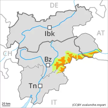
Considerable avalanche danger will be encountered over a wide area. Backcountry touring calls for careful route selection.
The new snow and wind slabs of Thursday can be released easily, even by a single winter sport participant, in all aspects above the tree line. The avalanche prone locations are to be found also in areas close to the tree line. They are sometimes covered with new snow and are difficult to recognise. Caution is to be exercised in gullies and bowls, and behind abrupt changes in the terrain. At a distance from ridgelines the wind slabs are larger. Isolated large avalanches are possible here. Remotely triggered avalanches are possible. Additionally avalanches can also be released in the old snowpack. Such avalanche prone locations are to be found in steep terrain above the tree line. In steep rocky terrain small and medium-sized loose snow avalanches are to be expected.
Snowpack
dp.6: cold, loose snow and wind dp.1: deep persistent weak layer
The snowpack will be generally prone to triggering. Over a wide area up to 30 cm of snow, and even more in some localities, has fallen since Thursday. The strong wind has transported the new snow significantly. The fresh snow as well as the extensive wind slabs formed during the snowfall are lying on soft layers in all aspects above the tree line. Also slopes close to the tree line are unfavourable. In some places new snow and wind slabs are lying on surface hoar. As a consequence of the sometimes storm force wind the wind slabs will increase in size additionally on Friday. Faceted weak layers exist in the snowpack, especially on steep slopes above the tree line. In shady places that are protected from the wind the snowpack is weaker. Whumpfing sounds and the formation of shooting cracks when stepping on the snowpack indicate the existence of a weak snowack.
Tendency
In some regions up to 50 cm of snow will fall on Saturday. In the north more snow will fall. On Saturday as a consequence of new snow and stormy weather there will be a significant increase in the avalanche danger.
Danger level
treeline
Avalanche Problem
Wind slab
Treeline
Persistent weak layer
2200m
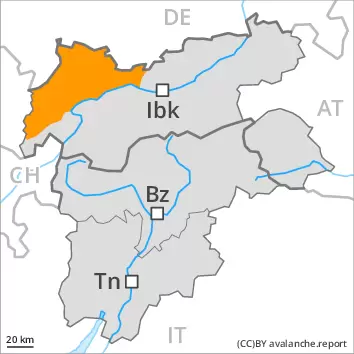
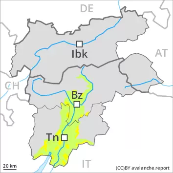
Wind slabs and weakly bonded old snow represent the main danger.
The fresh wind slabs of the last few days can be released by a single winter sport participant in all aspects above the tree line. The avalanche prone locations are quite prevalent but are clearly recognisable to the trained eye. Individual avalanche prone locations are to be found also in areas close to the tree line. Caution is to be exercised in gullies and bowls, and behind abrupt changes in the terrain. Mostly avalanches are medium-sized. Additionally avalanches can also be released in the old snowpack. Such avalanche prone locations are to be found on steep, little used shady slopes above approximately 2200 m and on steep sunny slopes above approximately 2500 m.
Snowpack
dp.6: cold, loose snow and wind dp.1: deep persistent weak layer
In some regions up to 10 cm of snow has fallen since Thursday. In the south less snow fell. The strong wind has transported the fresh and old snow significantly. The small quantity of fresh snow as well as the wind slabs formed by the northwesterly wind are lying on soft layers in all aspects. In some places various wind slab layers are lying on surface hoar, in particular in shady places that are protected from the wind. Faceted weak layers exist in the snowpack, especially on shady slopes above approximately 2200 m, as well as on sunny slopes above approximately 2500 m. Isolated whumpfing sounds indicate the existence of a weak snowack.
Tendency
Some snow will fall in some regions. On Saturday as a consequence of new snow and stormy weather there will be an increase in the avalanche danger within the current danger level.
Danger level
treeline
Avalanche Problem
Wind slab
Treeline
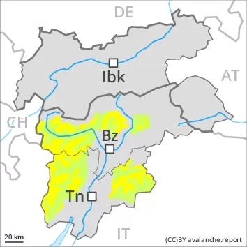
Fresh wind slabs require caution.
The wind will be strong at times. Adjacent to ridgelines as well as at elevated altitudes mostly small wind slabs will form. These can be released by a single winter sport participant in isolated cases. They are to be avoided in very steep terrain. Mostly avalanches are small.
Snowpack
dp.6: cold, loose snow and wind
The fresh wind slabs will be deposited on weak layers in particular on very steep shady slopes. In shady places that are protected from the wind the snowpack is weaker. Hardly any weak layers exist in the old snowpack.
Tendency
As a consequence of the strong to storm force northwesterly wind, the snow drift accumulations will increase in size on Saturday.
Danger level
treeline
Avalanche Problem
Wind slab
Treeline
Persistent weak layer
2200m
Wind slabs and weakly bonded old snow represent the main danger.
The fresh wind slabs of the last few days can be released even by a single winter sport participant in all aspects above the tree line. The avalanche prone locations are quite prevalent but are clearly recognisable to the trained eye. Individual avalanche prone locations are to be found also in areas close to the tree line. Caution is to be exercised in gullies and bowls, and behind abrupt changes in the terrain. Mostly avalanches are medium-sized. In the regions neighbouring those that are subject to danger level 3 (considerable) the avalanche danger is higher. Additionally avalanches can also be released in the old snowpack. Such avalanche prone locations are to be found on steep, little used shady slopes above approximately 2200 m and on steep sunny slopes above approximately 2500 m.
Snowpack
dp.6: cold, loose snow and wind dp.1: deep persistent weak layer
In some regions up to 10 cm of snow has fallen since Thursday. In the south less snow fell. The small quantity of fresh snow as well as the wind slabs formed by the sometimes storm force northwesterly wind are lying on soft layers in all aspects. In some places various wind slab layers are lying on surface hoar. In shady places that are protected from the wind the snowpack is weaker. Faceted weak layers exist in the snowpack, especially on shady slopes above approximately 2200 m, as well as on sunny slopes above approximately 2500 m. Whumpfing sounds and the formation of shooting cracks when stepping on the snowpack indicate the existence of a weak snowack.
Tendency
The new snow and wind slabs remain for the foreseeable future prone to triggering. In some regions increase in avalanche danger as a consequence of new snow and stormy weather, especially in the north.