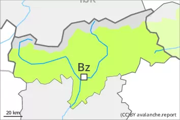
Danger level
 | 2200m |
|  |
|  |

![]()
Weakly bonded old snow requires caution.
Weak layers in the old snowpack can be released even now easily by individual winter sport participants. This applies in particular on the Main Alpine Ridge and to the north. Caution is to be exercised on steep, little used west, north and east facing slopes above approximately 2200 m, also at transitions from a shallow to a deep snowpack, when entering gullies and bowls for example. These avalanche prone locations are rare but are difficult to recognise. Avalanches are medium-sized.
Outgoing longwave radiation during the night was reduced over a wide area. The danger of wet and gliding avalanches will increase a little during the day, in particular on extremely steep sunny slopes below approximately 2400 m, as well as on steep, rather lightly snow-covered shady slopes below approximately 1800 m.
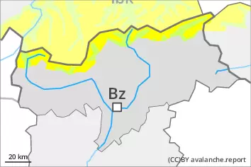
Snowpack
dp.1: deep persistent weak layer
dp.10: springtime scenario
The snowpack will be weakly bonded in some places, especially on very steep shady slopes between approximately 2200 and 2600 m, in isolated cases also on very steep west and east facing slopes.
The surface of the snowpack is frozen, but not to a significant depth. The solar radiation will give rise as the day progresses to gradual moistening of the snowpack. This applies especially on sunny slopes below approximately 2400 m, as well as on steep, rather lightly snow-covered shady slopes below approximately 1800 m.
In steep terrain there is a danger of falling on the hard snow surface. The snowpack will be subject to considerable local variations above the tree line. At low and intermediate altitudes less snow than usual is lying.
Tendency
Further decrease in danger of wet avalanches as the temperature drops.