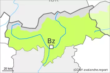
Danger level
 | treeline |
|  |
|  | ||||
| |
|  |


![]()
Fresh wind slabs require caution. Weakly bonded old snow above approximately 2200 m.
The fresh wind slabs are to be evaluated with care and prudence in particular on northwest to north to east facing aspects above the tree line. These are mostly rather small but can in some cases be released easily.
Weak layers in the old snowpack can be released even now by individual winter sport participants, especially on the Main Alpine Ridge and to the north. The avalanche prone locations are to be found in particular on steep, little used west, north and east facing slopes above approximately 2200 m and at transitions from a shallow to a deep snowpack. These places are rare but are difficult to recognise. Mostly avalanches are medium-sized.
Careful route selection is recommended.
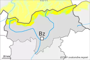
Snowpack
dp.6: cold, loose snow and wind
dp.1: deep persistent weak layer
10 to 20 cm of snow will fall on Saturday, in particular on the Main Alpine Ridge and to the north. As a consequence of new snow and a strong wind from westerly directions, sometimes avalanche prone wind slabs will form in particular on northeast, north and west facing slopes. The snowpack will be subject to considerable local variations above the tree line.
Isolated avalanche prone weak layers exist in the centre of the snowpack in particular on very steep west, north and east facing slopes, especially between approximately 2200 and 2600 m.
Over a wide area only a small amount of snow is lying for the time of year.
Tendency
5 to 10 cm of snow will fall on Sunday, in particular on the Main Alpine Ridge and to the north. The avalanche danger will persist.