Wind slabs and weakly bonded old snow represent the main danger.
Weak layers in the old snowpack can be released in some places by individual winter sport participants. This applies in particular on very steep shady slopes above approximately 2200 m, as well as on very steep east facing slopes above approximately 2400 m. Caution is to be exercised at transitions from a shallow to a deep snowpack, when entering gullies and bowls for example. As a consequence of new snow and a sometimes strong wind, wind slabs will form over a wide area. These can be released, even by small loads in isolated cases. Avalanche prone locations are to be found in particular on very steep northwest, north and east facing slopes above approximately 2200 m, especially adjacent to ridgelines. The number and size of avalanche prone locations will increase with altitude. As a consequence of the rain mostly small wet snow slides and avalanches are possible below approximately 1800 m. Individual small loose snow avalanches are possible.
Snowpack
dp.6: cold, loose snow and wind dp.1: deep persistent weak layer
Over a wide area 20 to 30 cm of snow will fall on Tuesday above approximately 1800 m. As a consequence of new snow and a sometimes strong wind, extensive wind slabs will form in particular adjacent to ridgelines on northwest, north and east facing slopes. These are lying on soft layers on steep shady slopes at high altitudes and in high Alpine regions. Faceted weak layers exist in the old snowpack, especially on shady slopes above approximately 2200 m, as well as on east facing slopes above approximately 2400 m. The rain will give rise to increasing and thorough wetting of the snowpack at low and intermediate altitudes.
Tendency
Wednesday: In some regions some new snow. Wind slabs require caution.
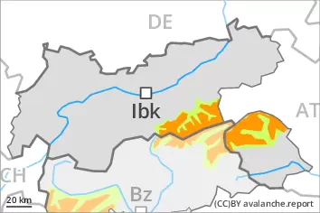
Danger level
2200m
Avalanche Problem
Wind slab
2200m
Persistent weak layer
2200m
Wind slabs and weakly bonded old snow represent the main danger.
Fresh wind slabs can be released even by a single winter sport participant. They are to be avoided in particular in steep terrain. The avalanche prone locations are to be found in particular on northwest to north to east facing aspects above approximately 2200 m and adjacent to ridgelines and in gullies and bowls. The avalanche prone locations are sometimes covered with new snow and are barely recognisable because of the poor visibility. As a consequence of the strong northerly wind the prevalence and size of these avalanche prone locations will increase as the day progresses. At elevated altitudes the avalanche prone locations are more prevalent. Weak layers in the old snowpack can be released in some places by individual winter sport participants. This applies in particular on very steep shady slopes above approximately 2200 m, as well as on very steep east facing slopes above approximately 2400 m. Caution is to be exercised at transitions from a shallow to a deep snowpack, when entering gullies and bowls for example. Small loose snow avalanches are possible.
Snowpack
dp.6: cold, loose snow and wind dp.1: deep persistent weak layer
Over a wide area 20 to 40 cm of snow will fall on Tuesday above approximately 1800 m. As a consequence of new snow and a sometimes strong wind, sometimes avalanche prone wind slabs will form. These are lying on soft layers on steep shady slopes at high altitudes and in high Alpine regions. Faceted weak layers exist in the old snowpack, especially on shady slopes above approximately 2200 m, as well as on east facing slopes above approximately 2400 m. The rain will give rise to increasing and thorough wetting of the snowpack at low and intermediate altitudes.
Tendency
Wednesday: In some regions some new snow. Wind slabs require caution.
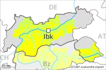
Danger level
2200m
Avalanche Problem
Wind slab
2200m
Persistent weak layer
2200m
Wind slabs and weakly bonded old snow represent the main danger.
Fresh wind slabs can be released even by a single winter sport participant. They are to be avoided in particular in steep terrain. The avalanche prone locations are to be found in particular on northwest to north to east facing aspects above approximately 2200 m and adjacent to ridgelines and in gullies and bowls. The avalanche prone locations are sometimes covered with new snow and are barely recognisable because of the poor visibility. As a consequence of the strong northerly wind the prevalence and size of these avalanche prone locations will increase as the day progresses. At elevated altitudes the avalanche prone locations are more prevalent. Weak layers in the old snowpack can be released in some places by individual winter sport participants. This applies in particular on very steep shady slopes above approximately 2200 m, as well as on very steep east facing slopes above approximately 2400 m. Caution is to be exercised at transitions from a shallow to a deep snowpack, when entering gullies and bowls for example. Small loose snow avalanches are possible.
Snowpack
dp.6: cold, loose snow and wind dp.1: deep persistent weak layer
Over a wide area 10 to 20 cm of snow, and even more in some localities, will fall on Tuesday above approximately 1800 m. As a consequence of new snow and a sometimes strong wind, sometimes avalanche prone wind slabs will form. These are lying on soft layers on steep shady slopes at high altitudes and in high Alpine regions. Faceted weak layers exist in the old snowpack, especially on shady slopes above approximately 2200 m, as well as on east facing slopes above approximately 2400 m. The rain will give rise to increasing and thorough wetting of the snowpack at low and intermediate altitudes.
Tendency
Wednesday: In some regions some new snow. Wind slabs require caution.
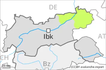
Danger level
Fresh wind slabs require caution.
As a consequence of new snow and a sometimes strong wind, wind slabs will form over a wide area. These can in very isolated cases be released. Avalanche prone locations are to be found in particular on extremely steep shady slopes at high altitude,, also adjacent to ridgelines. As a consequence of the rain mostly small wet snow slides are possible below approximately 1800 m.
Snowpack
dp.6: cold, loose snow and wind dp.3: rain
Over a wide area 20 to 30 cm of snow will fall on Tuesday above approximately 1800 m. As a consequence of new snow and a sometimes strong wind, extensive wind slabs will form in particular adjacent to ridgelines on northwest, north and east facing slopes. The rain will give rise to increasing and thorough wetting of the snowpack at low and intermediate altitudes.
Tendency
Wednesday: In some regions some new snow. Wind slabs require caution.