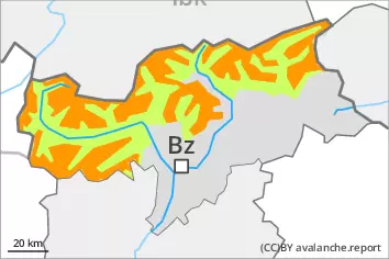
Wind slabs and weakly bonded old snow represent the main danger.
The new snow and wind slabs can be released easily, even by a single winter sport participant,. The avalanche prone locations are to be found in particular on northwest to north to east facing aspects above approximately 2200 m. Caution is to be exercised adjacent to ridgelines and in pass areas, as well as in gullies and bowls. The avalanche prone locations are sometimes covered with new snow and are difficult to recognise. At elevated altitudes the avalanche prone locations are more prevalent. Avalanches can reach medium size. Avalanches can additionally in some places be released in the old snowpack by a single winter sport participant, especially on very steep shady slopes above approximately 2200 m, as well as on very steep east and west facing slopes above approximately 2400 m. Caution is to be exercised at transitions from a shallow to a deep snowpack. Backcountry touring calls for careful route selection.
Snowpack
dp.6: cold, loose snow and wind dp.1: deep persistent weak layer
Over a wide area 20 to 30 cm of snow, and even more in some localities, has fallen since Tuesday, in particular in the eastern part of the main Alpine ridge and in the Ortler Range. As a consequence of new snow and a strong wind, sometimes avalanche prone wind slabs formed. The new snow and wind slabs are lying on the unfavourable surface of an old snowpack in particular on shady slopes at high altitudes and in high Alpine regions. In some cases the various wind slabs have bonded still only poorly with each other and the old snowpack. As a consequence of the strong wind the wind slabs will increase in size additionally on Wednesday. Faceted weak layers exist in the old snowpack, especially on shady slopes above approximately 2200 m, as well as on east and west facing slopes above approximately 2400 m. The solar radiation will give rise as the day progresses to slight moistening of the snowpack in particular on sunny slopes.
Tendency
The weather conditions facilitated a gradual stabilisation of the snow drift accumulations. As a consequence of warming during the day and solar radiation wet snow slides and avalanches are to be expected.
Danger level
2200m
Avalanche Problem
Wind slab
2200m
Persistent weak layer
2200m
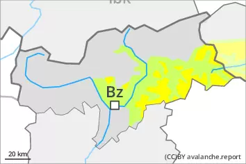
Wind slabs and weakly bonded old snow require caution.
Fresh wind slabs can be released even by a single winter sport participant. They are to be avoided in particular in steep terrain. The avalanche prone locations are to be found in particular on northwest to north to east facing aspects above approximately 2200 m and adjacent to ridgelines and in gullies and bowls. The avalanche prone locations are sometimes covered with new snow and are difficult to recognise. At elevated altitudes the avalanche prone locations are more prevalent. Avalanches can reach medium size. Avalanches can additionally in isolated cases be released in the old snowpack by a single winter sport participant, especially on very steep shady slopes above approximately 2200 m, as well as on very steep east and west facing slopes above approximately 2400 m. Caution is to be exercised at transitions from a shallow to a deep snowpack. Meticulous route selection is recommended.
Snowpack
dp.6: cold, loose snow and wind dp.1: deep persistent weak layer
Over a wide area 10 to 20 cm of snow, and even more in some localities, has fallen since Tuesday. As a consequence of new snow and a strong wind, sometimes avalanche prone wind slabs formed. These are lying on soft layers in particular on steep shady slopes at high altitudes and in high Alpine regions. In some cases the various wind slabs have bonded still only poorly with each other and the old snowpack. On Wednesday the wind slabs will increase in size additionally. Faceted weak layers exist in the old snowpack, especially on shady slopes above approximately 2200 m, as well as on east and west facing slopes above approximately 2400 m. The solar radiation will give rise as the day progresses to slight moistening of the snowpack in particular on sunny slopes.
Tendency
The weather conditions facilitated a gradual stabilisation of the snow drift accumulations. As a consequence of warming during the day and solar radiation moist snow slides and avalanches are possible.
Danger level
Avalanche Problem
Wind slab
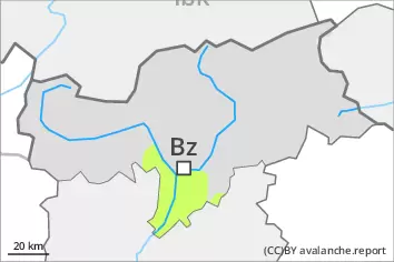
Fresh wind slabs require caution.
As a consequence of new snow and a sometimes strong wind, mostly small wind slabs formed since Tuesday in particular at elevated altitudes. The fresh wind slabs can be released by a single winter sport participant in isolated cases in particular on steep shady slopes. The wind slabs are to be avoided in particular in terrain where there is a danger of falling. Caution is to be exercised adjacent to ridgelines and in gullies and bowls. The avalanche prone locations are rather rare but are barely recognisable because of the poor visibility.
Snowpack
dp.6: cold, loose snow and wind
In some localities up to 10 cm of snow has fallen since Tuesday. As a consequence of new snow and a strong wind, sometimes avalanche prone wind slabs formed. These are lying on soft layers in particular on steep shady slopes at high altitudes and in high Alpine regions. On Wednesday the wind slabs will increase in size additionally. Hardly any weak layers exist in the old snowpack. Snow depths vary greatly, depending on the infuence of the wind. The solar radiation will give rise in the early morning to slight moistening of the snowpack.
Tendency
The weather conditions facilitated a gradual stabilisation of the snow drift accumulations. As a consequence of warming during the day and solar radiation moist snow slides and avalanches are possible.