Wet snow represents the main danger. In addition the more recent wind slabs must be taken into account. Weakly bonded old snow in particular on steep shady slopes.
As a consequence of a strong wind from northwesterly directions, sometimes avalanche prone wind slabs formed on Wednesday in particular adjacent to ridgelines and in gullies and bowls. At elevated altitudes the avalanche prone locations are more prevalent. At transitions from a shallow to a deep snowpack the likelihood of avalanches being released is greater. Avalanches can be released in the old snowpack, even by small loads in isolated cases. This applies in particular on very steep shady slopes. Caution is to be exercised at transitions from a shallow to a deep snowpack. As a consequence of warming during the day and solar radiation individual mostly small moist snow slides are to be expected as the day progresses. This applies in particular on sunny slopes, as well as on shady slopes below approximately 2400 m. Backcountry tours and off-piste skiing should be concluded timely.
Snowpack
In some cases the wind slabs have bonded still only poorly with the old snowpack. In some places wind slabs are lying on a hard crust. Individual weak layers exist in the old snowpack in particular on shady slopes. This applies above approximately 2200 m. Sunshine and high temperatures will give rise as the day progresses to gradual moistening of the snowpack in particular on sunny slopes. These conditions will bring about a weakening of the snowpack.
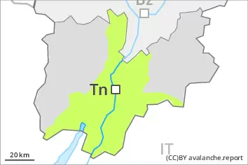
Tendency
On Sunday it will be partly cloudy. Slight decrease in danger of moist and wet snow slides as the temperature drops.
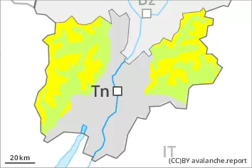
Danger level
In the late morning as a consequence of warming there will be a gradual increase in the danger of moist and wet snow slides. Old wind slabs are to be evaluated with care and prudence.
The wind slabs of the last few days are to be evaluated with care and prudence in particular on steep shady slopes at elevated altitudes. The somewhat older wind slabs are to be avoided in particular in very steep terrain, also adjacent to ridgelines and in gullies and bowls. Sunshine and high temperatures will give rise from early morning to increasing moistening of the snowpack over a wide area in particular on southeast, south and southwest facing slopes. In particular is these aspects individual mostly small moist and wet snow slides are possible as a consequence of warming during the day. Backcountry tours and off-piste skiing should be concluded timely.
Snowpack
The mostly small wind slabs are in some cases still prone to triggering in particular on shady slopes above the tree line. Above approximately 2000 m snow depths vary greatly, depending on the infuence of the wind. In all regions below approximately 2000 m only a little snow is lying. Sunshine and high temperatures will give rise as the day progresses to increasing moistening of the snowpack.
Tendency
On Sunday it will be partly cloudy. Slight decrease in danger of moist and wet snow slides as the temperature drops.