Weakly bonded old snow is to be evaluated with care and prudence. More moist and wet avalanches are possible.
Weak layers in the old snowpack can be released in very isolated cases by winter sport participants, especially on very steep shady slopes above approximately 2400 m. The avalanches can penetrate even deep layers and reach medium size. Caution is to be exercised in particular on extremely steep northeast facing slopes. In addition the fresh wind slabs should be taken into account. This applies adjacent to ridgelines and in pass areas in high Alpine regions, in particular in the regions exposed to heavier precipitation.
Already in the early morning, individual, then as a consequence of warming during the day more, and in some cases even medium-sized, wet avalanches are possible. This applies especially on sunny slopes below approximately 2400 m, as well as in all aspects below approximately 2200 m.
Snowpack
dp.1: deep persistent weak layer dp.10: springtime scenario
Faceted weak layers exist in the old snowpack, especially on shady slopes above approximately 2400 m.
The weather conditions gave rise to increasing and thorough wetting of the snowpack. Outgoing longwave radiation during the night will be severely restricted. The surface of the snowpack will freeze very little and will soften quickly. All aspects, below approximately 2400 m: The snowpack will be wet all the way through over a wide area. At higher altitudes the snowpack is dryer.
Tendency
Gradual increase in avalanche danger as a consequence of new snow and strong wind. Down to low altitudes snow will fall on Monday over a wide area.
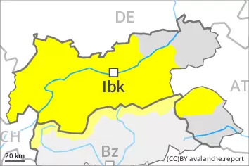
AM Danger level
2400m
Avalanche Problem
Persistent weak layer
2400m
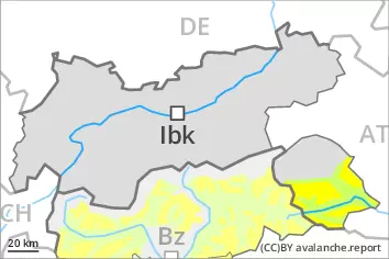
PM Danger level
2400m
Avalanche Problem
Persistent weak layer
2400m
Wet snow
2400m
Weakly bonded old snow is to be evaluated with care and prudence. Gradual increase in danger of wet avalanches in the course of the day.
Late morning: Weak layers in the old snowpack can be released in very isolated cases by winter sport participants, especially on very steep shady slopes above approximately 2400 m. The avalanches can be released in the weakly bonded old snow and reach medium size. Caution is to be exercised in particular on extremely steep northeast facing slopes. In addition the fresh wind slabs should be taken into account. This applies adjacent to ridgelines and in pass areas in high Alpine regions, in particular in the regions exposed to heavier precipitation.
During the day: Gradual increase in danger of wet avalanches. As a consequence of warming during the day and solar radiation individual small to medium-sized wet avalanches are possible below approximately 2400 m. This applies especially on sunny slopes below approximately 2400 m, as well as in all aspects below approximately 2200 m.
Snowpack
dp.1: deep persistent weak layer dp.10: springtime scenario
Some snow has fallen since Friday in the north and in the east. In particular in the Rieserferner Mountains and in the Deferegger Alps 15 to 25 cm of snow, and even more in some localities, has fallen. As a consequence of new snow and a moderate wind, sometimes avalanche prone wind slabs formed in the regions exposed to heavier precipitation. Fresh wind slabs are lying on soft layers on near-ridge shady slopes in high Alpine regions. Faceted weak layers exist in the old snowpack, especially on shady slopes above approximately 2400 m. Outgoing longwave radiation during the night will be quite good. The surface of the snowpack has frozen to form a strong crust only at high altitudes and will soften during the day. The weather conditions as the day progresses gave rise to increasing and thorough wetting of the snowpack.
Tendency
Gradual increase in avalanche danger as a consequence of new snow and strong wind.
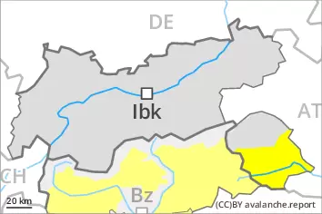
Danger level
2400m
Avalanche Problem
Wet snow
2400m
Wet avalanches are still possible.
Already in the early morning, wet avalanches are possible. This applies in all aspects below approximately 2400 m. In isolated cases avalanches can release the wet snowpack and reach medium size.
Snowpack
dp.10: springtime scenario
Only a small amount of snow is lying for the time of year at low and intermediate altitudes. Outgoing longwave radiation during the night will be severely restricted. The surface of the snowpack will freeze very little and will soften quickly. The snowpack will be wet all the way through over a wide area.
Tendency
Gradual increase in avalanche danger as a consequence of new snow and strong wind. Down to low altitudes snow will fall on Monday over a wide area.