As a consequence of new snow and a gathering storm force wind from northwesterly directions, avalanche prone wind slabs will form. From early morning the previously small wind slabs will increase in size appreciably. The avalanche prone locations are to be found on steep slopes of all aspects above approximately 2000 m and in gullies and bowls, and behind abrupt changes in the terrain. The wind slabs can be released even by a single winter sport participant. The prevalence of avalanche prone locations and likelihood of triggering will increase with altitude. As a consequence of the heavy snowfall loose snow avalanches are to be expected from the late morning, in particular on very steep slopes.
Snowpack
dp.6: cold, loose snow and wind
Over a wide area up to 30 cm of snow will fall. The weather will be cold. As a consequence of the strong to storm force northwesterly wind, fresh snow drift accumulations will form. In some cases the wind slabs have bonded poorly together. Whumpfing sounds and the formation of shooting cracks when stepping on the snowpack indicate poor snowpack stability.
All aspects below approximately 2400 m: The old snowpack will be wet all the way through over a wide area. As a consequence of low temperatures the snowpack will consolidate. At low and intermediate altitudes from a snow sport perspective, in most cases insufficient snow is lying.
Tendency
The danger of dry slab avalanches will persist. Some snow will fall on Tuesday over a wide area, this applies in particular until the early morning. The wind will be strong in some regions.
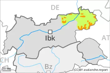
Danger level
2000m
Avalanche Problem
Wind slab
2000m
Persistent weak layer
2400m
Fresh wind slabs represent the main danger. Weakly bonded old snow requires caution.
As a consequence of new snow and a gathering storm force wind from northwesterly directions, avalanche prone wind slabs will form. From early morning the previously small wind slabs will increase in size appreciably. The avalanche prone locations are to be found on steep slopes of all aspects above approximately 2000 m and in gullies and bowls, and behind abrupt changes in the terrain. The wind slabs can be released even by a single winter sport participant. In some cases avalanches are medium-sized. The prevalence of avalanche prone locations and likelihood of triggering will increase with altitude. As a consequence of the heavy snowfall loose snow avalanches are to be expected from the late morning, in particular on very steep slopes.
Weak layers in the old snowpack can be released in very isolated cases by winter sport participants, especially on very steep shady slopes above approximately 2400 m. The avalanches can be released in the weakly bonded old snow and reach medium size. Caution is to be exercised in particular on extremely steep northeast facing slopes.
Snowpack
dp.6: cold, loose snow and wind dp.1: deep persistent weak layer
Over a wide area up to 30 cm of snow, and even more in some localities, will fall. This applies in particular in the west and in the north as well as in the High Tauern. The weather will be cold. As a consequence of the strong to storm force northwesterly wind, fresh snow drift accumulations will form. In some cases the various wind slabs have bonded poorly together. Whumpfing sounds and the formation of shooting cracks when stepping on the snowpack indicate poor snowpack stability.
Faceted weak layers exist in the old snowpack, especially on shady slopes above approximately 2400 m.
All aspects below approximately 2400 m: The old snowpack will be wet all the way through over a wide area. As a consequence of low temperatures the snowpack will consolidate. At low and intermediate altitudes from a snow sport perspective, in most cases insufficient snow is lying.
Tendency
The danger of dry slab avalanches will persist. Some snow will fall on Tuesday over a wide area, this applies in particular until the early morning. The wind will be strong in some regions.
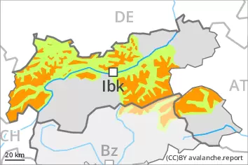
Danger level
2000m
Avalanche Problem
Wind slab
2000m
Persistent weak layer
2400m
The sometimes storm force wind will transport the snow. Wind slabs and weakly bonded old snow represent the main danger.
As a consequence of a gathering storm force wind from northwesterly directions, sometimes avalanche prone wind slabs will form. The avalanche prone locations are to be found in gullies and bowls, and behind abrupt changes in the terrain above approximately 2000 m. The prevalence of avalanche prone locations and likelihood of triggering will increase with altitude. Avalanches can reach medium size. Dry avalanches can additionally in very isolated cases be released in the weakly bonded old snow also, especially on very steep shady slopes above approximately 2400 m. Avalanches can penetrate even deep layers and reach medium size. Caution is to be exercised in particular on extremely steep northeast facing slopes.
Snowpack
dp.6: cold, loose snow and wind dp.1: deep persistent weak layer
10 to 20 cm of snow has fallen since Sunday. The wind will be strong to storm force over a wide area. The weather will be cold. As a consequence of northwesterly wind, brittle wind slabs will form. The fresh wind slabs will be deposited on soft layers at high altitude. Faceted weak layers exist in the old snowpack, especially on northwest, north and northeast facing slopes above approximately 2400 m.
All aspects below approximately 2400 m: The old snowpack will be wet all the way through over a wide area. As a consequence of low temperatures the snowpack will consolidate. At low and intermediate altitudes from a snow sport perspective, in most cases insufficient snow is lying.
Tendency
The danger of dry slab avalanches will persist. The wind will be strong in particular in the east. The weather will be cold.
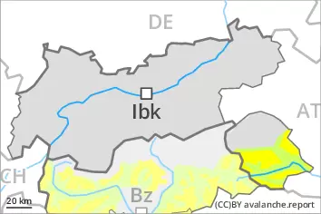
Danger level
2000m
Avalanche Problem
Wind slab
2000m
Persistent weak layer
2400m
As a consequence of new snow and a storm force wind, sometimes avalanche prone wind slabs will form. Weakly bonded old snow is to be evaluated with care and prudence.
As a consequence of new snow and a gathering storm force wind from northwesterly directions, sometimes avalanche prone wind slabs will form. From early morning the wind slabs will increase in size additionally. The avalanche prone locations are to be found in gullies and bowls, and behind abrupt changes in the terrain above approximately 2000 m. The prevalence of avalanche prone locations and likelihood of triggering will increase with altitude. Avalanches can reach medium size. Dry avalanches can additionally in isolated cases be released in the weakly bonded old snow also, especially on very steep shady slopes above approximately 2400 m. Avalanches can penetrate even deep layers and reach medium size. Caution is to be exercised in particular on extremely steep northeast facing slopes.
Snowpack
dp.6: cold, loose snow and wind dp.1: deep persistent weak layer
10 to 20 cm of snow will fall. The wind will be strong to storm force over a wide area. The weather will be cold. As a consequence of new snow and northwesterly wind, brittle wind slabs will form. The various wind slabs have bonded insufficiently together. Faceted weak layers exist in the old snowpack, especially on northwest, north and northeast facing slopes above approximately 2400 m.
All aspects below approximately 2400 m: The old snowpack will be wet all the way through over a wide area. As a consequence of low temperatures the snowpack will consolidate. At low and intermediate altitudes from a snow sport perspective, in most cases insufficient snow is lying.
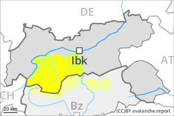
Tendency
The danger of dry slab avalanches will persist. Some snow will fall on Tuesday in some regions, this applies in particular until the early morning. The wind will be strong in some regions.