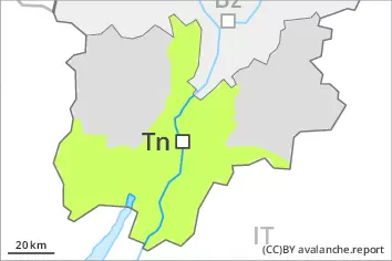
Danger level
 | 2000m |
|  |
|  | ||||
| |
|  |


![]()
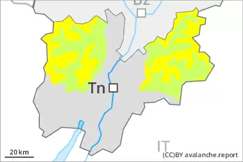
Fresh wind slabs represent the main danger. Especially on very steep shady slopes the avalanches can be triggered in the old snow and reach medium size in isolated cases.
As a consequence of new snow and a strong to storm force wind from northwesterly directions, sometimes avalanche prone wind slabs formed. They must be evaluated with care and prudence in all aspects. The avalanche prone locations are to be found at transitions from a shallow to a deep snowpack, when entering gullies and bowls for example above approximately 2000 m. The prevalence of avalanche prone locations and likelihood of triggering will increase with altitude. Avalanches can reach medium size.
Dry avalanches can additionally in isolated cases be released in the weakly bonded old snow also, especially on very steep shady slopes above approximately 2400 m. In isolated cases avalanches can penetrate even deep layers.
Meticulous route selection is recommended.
Snowpack
dp.6: cold, loose snow and wind
dp.1: deep persistent weak layer
Over a wide area 5 to 15 cm of snow has fallen. As a consequence of the strong to storm force northwesterly wind, fresh snow drift accumulations formed during the last few days. In some cases the various wind slabs have bonded poorly together. As a consequence of the strong wind the wind slabs will increase in size additionally on Tuesday.
Faceted weak layers exist in the old snowpack, especially on northwest, north and northeast facing slopes above approximately 2400 m.
Tendency
Over a wide area moderate northwesterly wind. The weather conditions will bring about a very slow stabilisation of the snow drift accumulations.