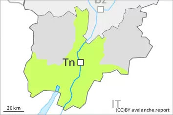
Danger level
 | 2200m |
|  |
|  | ||||
| |
|  |


![]()
Fresh wind slabs represent the main danger. Weakly bonded old snow is to be evaluated with care and prudence.
The wind slabs of the last few days can be released by a single winter sport participant in some cases. They are to be evaluated with care and prudence in particular in very steep terrain. The avalanche prone locations are to be found in particular adjacent to ridgelines and in gullies and bowls above approximately 2200 m. At elevated altitudes the avalanche prone locations are more prevalent. As a consequence of warming, the likelihood of slab avalanches being released will increase. Avalanches can reach medium size.
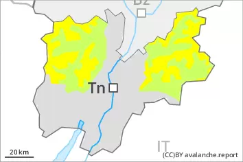
Dry avalanches can additionally in isolated cases be released in the weakly bonded old snow also, especially on very steep shady slopes above approximately 2400 m.
As the day progresses the likelihood of moist and wet avalanches being released will increase in particular on steep sunny slopes.
Snowpack
dp.6: cold, loose snow and wind
dp.1: deep persistent weak layer
As a consequence of the strong to storm force northwesterly wind, snow drift accumulations formed during the last few days. In some cases the various wind slabs have bonded poorly together. As a consequence of the strong wind the wind slabs will increase in size additionally on Wednesday.
Faceted weak layers exist in the old snowpack, especially on steep shady slopes above approximately 2400 m.
Sunshine and high temperatures will give rise as the day progresses to gradual moistening of the snowpack in particular on sunny slopes.
Tendency
On Thursday it will be mild. The wind slabs remain in some cases prone to triggering in particular on shady slopes.
Further increase in danger of moist and wet avalanches as a consequence of warming.