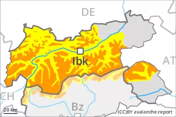
Wind slabs represent the main danger. Wet snow requires caution.
The wind slabs of the last few days can be released easily, even by a single winter sport participant,. The avalanche prone locations are to be found in particular on steep west, north and east facing slopes above approximately 2200 m. Caution is to be exercised in gullies and bowls, and behind abrupt changes in the terrain. Additionally in some places avalanches can also be triggered in deep layers and reach large size. As a consequence of warming wet and gliding avalanches are possible, in the event of prolonged bright spells especially below approximately 2200 m as well as.
Snowpack
dp.6: cold, loose snow and wind dp.10: springtime scenario
10 to 20 cm of snow fell on Wednesday. As a consequence of the strong to storm force northwesterly wind, snow drift accumulations formed during the last few days. In some cases the various wind slabs have bonded poorly together, in particular on shady slopes. On sunny slopes the snowpack is better bonded. Faceted weak layers exist in the old snowpack, especially on shady slopes above approximately 2400 m.
Outgoing longwave radiation during the night will be severely restricted over a wide area. The spring-like weather conditions on Thursday will give rise to gradual and thorough wetting of the snowpack below approximately 2200 m.
Tendency
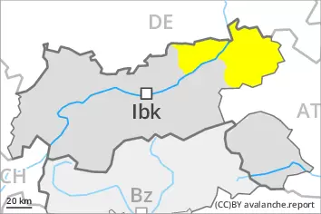
Some snow will fall on Friday. The wind will be strong. At elevated altitudes the danger of dry avalanches will increase. The danger of wet avalanches will decrease gradually.
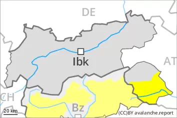
The wind slabs of the last few days can be released by a single winter sport participant in some cases. They are to be evaluated with care and prudence in particular on steep west, north and east facing slopes above approximately 2200 m. Dry avalanches can additionally in very isolated cases be released in the weakly bonded old snow also. Avalanches can reach medium size. As a consequence of warming wet avalanches are possible, in the event of prolonged bright spells especially below approximately 2200 m as well as.
Snowpack
dp.6: cold, loose snow and wind dp.10: springtime scenario
As a consequence of the strong to storm force northwesterly wind, snow drift accumulations formed during the last few days. These are in some cases still prone to triggering in particular on very steep shady slopes. On sunny slopes the snowpack is better bonded. Faceted weak layers exist in the old snowpack, especially on steep shady slopes above approximately 2400 m.
On Thursday it will be mild. Outgoing longwave radiation during the night will be severely restricted over a wide area. The spring-like weather conditions on Thursday will give rise to gradual and thorough wetting of the snowpack below approximately 2200 m. Some snow will fall in the evening in some regions.
Tendency
As a consequence of new snow and a sometimes strong wind from southwesterly directions, mostly small wind slabs will form on Friday. At elevated altitudes the danger of dry avalanches will increase. The danger of wet avalanches will decrease gradually.
Danger level
Avalanche Problem
Wet snow
Wind slab
1800m
Wet snow requires caution. Wind slabs are to be avoided.
As a consequence of warming wet and gliding avalanches are possible, in the event of prolonged bright spells especially as well as. As a consequence of the rain more frequent wet avalanches are possible in the evening. The wind slabs of the last few days can be released by a single winter sport participant in some cases. The avalanche prone locations are to be found in particular on steep shady slopes above approximately 1800 m. Caution is to be exercised in gullies and bowls, and behind abrupt changes in the terrain.
Snowpack
dp.10: springtime scenario dp.6: cold, loose snow and wind
As a consequence of the strong to storm force northwesterly wind, snow drift accumulations formed during the last few days. In some cases the various wind slabs have bonded poorly together, in particular on shady slopes. Outgoing longwave radiation during the night will be severely restricted over a wide area. The spring-like weather conditions on Thursday will give rise to gradual and thorough wetting of the snowpack below approximately 2200 m.