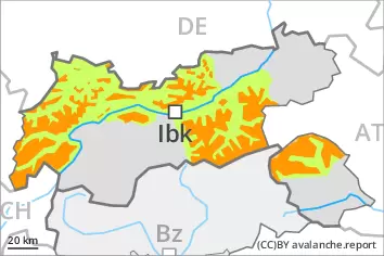
New snow requires caution. Weakly bonded old snow requires caution.
As a consequence of new snow and a sometimes storm force wind from northwesterly directions, avalanche prone wind slabs formed. Since Monday the wind slabs will increase in size appreciably. The avalanche prone locations are to be found especially on steep west, north and east facing slopes above the tree line, in particular in gullies and bowls, and behind abrupt changes in the terrain. Avalanches can in many places be released, even by a single winter sport participant. As a consequence of warming, the likelihood of slab avalanches being released will increase a little. These can in isolated cases release deeper layers of the snowpack.
Weak layers in the old snowpack can be released in very isolated cases by winter sport participants, especially on very steep shady slopes above approximately 2400 m. The avalanches can be released in the weakly bonded old snow and reach medium size.
As the snowfall level rises individual mostly small gliding avalanches and wet snow slides are possible.
Snowpack
dp.6: cold, loose snow and wind dp.1: deep persistent weak layer
As a consequence of the strong to storm force northwesterly wind, snow drift accumulations formed during the last few days. 10 to 20 cm of snow will fall. The strong wind will transport the new snow significantly. In some cases the various wind slabs have bonded poorly together. Whumpfing sounds and the formation of shooting cracks when stepping on the snowpack indicate poor snowpack stability.
Faceted weak layers exist in the old snowpack, especially on shady slopes above approximately 2400 m.
The rain will give rise as the day progresses to gradual and thorough wetting of the snowpack in particular below the tree line.
Tendency
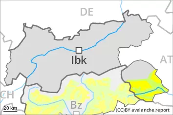
On Thursday it will be mild. As a consequence of mild temperatures the snow drift accumulations will stabilise. These spring-like weather conditions will give rise to rapid softening of the snowpack in particular at low and intermediate altitudes. Some snow will fall from the afternoon.
Danger level
2000m
Avalanche Problem
Wind slab
2000m
Persistent weak layer
2400m
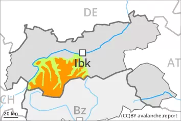
Fresh wind slabs represent the main danger. Weakly bonded old snow requires caution.
The fresh wind slabs can be released easily, even by a single winter sport participant,. The avalanche prone locations are to be found in particular on steep west, north and east facing slopes above approximately 2000 m. Caution is to be exercised in gullies and bowls, and behind abrupt changes in the terrain. At elevated altitudes the avalanche prone locations are more prevalent. As a consequence of warming, the likelihood of slab avalanches being released will increase. These can in some cases release deeper layers of the snowpack and reach large size. Dry avalanches can additionally in some places be released in the weakly bonded old snow also, especially on very steep shady slopes above approximately 2400 m. As a consequence of warming, the likelihood of wet and gliding avalanches being released will increase. Careful route selection is recommended.
Snowpack
dp.6: cold, loose snow and wind dp.1: deep persistent weak layer
Over a wide area 20 to 30 cm of snow, and even more in some localities, has fallen. As a consequence of the strong to storm force northwesterly wind, snow drift accumulations formed during the last few days. In some cases the various wind slabs have bonded poorly together. As a consequence of the strong wind the wind slabs will increase in size additionally on Wednesday. Faceted weak layers exist in the old snowpack, especially on shady slopes above approximately 2400 m. Whumpfing sounds and the formation of shooting cracks when stepping on the snowpack indicate poor snowpack stability. The high temperatures as the day progresses will give rise to gradual and thorough wetting of the snowpack in particular below the tree line.
Tendency
On Thursday it will be mild. As a consequence of mild temperatures the snow drift accumulations will stabilise. These spring-like weather conditions will give rise to rapid softening of the snowpack in particular at low and intermediate altitudes. Some snow will fall from the afternoon in some regions.
Danger level
treeline
Avalanche Problem
New snow
Treeline
New snow requires caution.
As a consequence of new snow and a sometimes storm force wind from northwesterly directions, avalanche prone wind slabs formed. Since Monday the wind slabs will increase in size appreciably. The avalanche prone locations are to be found especially on steep west, north and east facing slopes above the tree line, in particular in gullies and bowls, and behind abrupt changes in the terrain. Avalanches can in many places be released, even by a single winter sport participant. As a consequence of warming, the likelihood of slab avalanches being released will increase a little. These can in isolated cases release deeper layers of the snowpack.
As the snowfall level rises individual mostly small gliding avalanches and wet snow slides are possible.
Snowpack
dp.6: cold, loose snow and wind
As a consequence of the strong to storm force northwesterly wind, snow drift accumulations formed during the last few days. 10 to 20 cm of snow will fall. The strong wind will transport the new snow significantly. In some cases the various wind slabs have bonded poorly together. Whumpfing sounds and the formation of shooting cracks when stepping on the snowpack indicate poor snowpack stability.
The rain will give rise as the day progresses to gradual and thorough wetting of the snowpack in particular below the tree line.
Tendency
On Thursday it will be mild. As a consequence of mild temperatures the snow drift accumulations will stabilise. These spring-like weather conditions will give rise to rapid softening of the snowpack in particular at low and intermediate altitudes.
Danger level
2200m
Avalanche Problem
Wind slab
2200m
Persistent weak layer
2400m
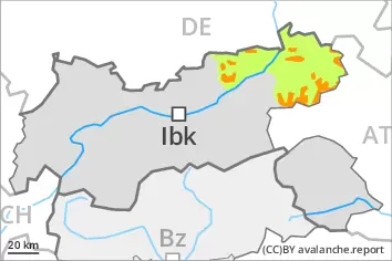
Fresh wind slabs represent the main danger. Weakly bonded old snow is to be evaluated with care and prudence.
The wind slabs of the last few days can be released by a single winter sport participant in some cases. They are to be evaluated with care and prudence in particular in very steep terrain. The avalanche prone locations are to be found in particular adjacent to ridgelines and in gullies and bowls above approximately 2200 m. At elevated altitudes the avalanche prone locations are more prevalent. As a consequence of warming, the likelihood of slab avalanches being released will increase. Avalanches can reach medium size. Dry avalanches can additionally in isolated cases be released in the weakly bonded old snow also, especially on very steep shady slopes above approximately 2400 m. As the day progresses the likelihood of wet avalanches being released will increase in particular on steep sunny slopes.
Snowpack
dp.6: cold, loose snow and wind dp.1: deep persistent weak layer
As a consequence of the strong to storm force northwesterly wind, snow drift accumulations formed during the last few days. In some cases the various wind slabs have bonded poorly together. As a consequence of the strong wind the wind slabs will increase in size additionally on Wednesday. Faceted weak layers exist in the old snowpack, especially on steep shady slopes above approximately 2400 m. Sunshine and high temperatures will give rise as the day progresses to gradual moistening of the snowpack in particular on sunny slopes.
Tendency
On Thursday it will be mild. The wind slabs remain in some cases prone to triggering in particular on shady slopes. These spring-like weather conditions will give rise to rapid softening of the snowpack in particular at low and intermediate altitudes.