Danger level
 | 2200m |
|  |
|  | ||||
|  |
| |


![]()
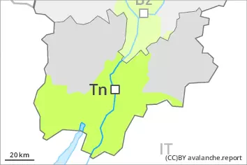
Fresh wind slabs represent the main danger. Wet avalanches below approximately 2200 m.
As the day progresses as a consequence of new snow and wind there will be an increase in the danger of dry avalanches within the current danger level. The fresh wind slabs can be released even by a single winter sport participant. They are to be evaluated with care and prudence above approximately 2200 m. At elevated altitudes the likelihood of avalanches being released is greater. Dry avalanches can additionally in very isolated cases be released in the weakly bonded old snow also.
Avalanches can reach medium size.
As a consequence of the rain wet avalanches are possible, especially below approximately 2200 m.
Snowpack
dp.6: cold, loose snow and wind
dp.3: rain
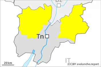
As a consequence of snowfall above approximately 1800 m and the moderate to strong wind, fresh snow drift accumulations will form on Friday. These are prone to triggering in all aspects above approximately 2200 m. At elevated altitudes the snowpack is weaker.
Faceted weak layers exist in the old snowpack, especially on steep shady slopes above approximately 2400 m.
Outgoing longwave radiation during the night will be severely restricted over a wide area. The surface of the snowpack is not frozen and will already be soft in the early morning. The rain will give rise to a loss of strength within the snowpack.
Tendency
On Saturday the wind will be moderate to strong. The wind slabs remain prone to triggering on steep shady slopes.
On very steep slopes moist loose snow slides are to be expected.