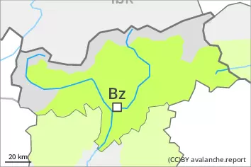
Danger level
 | 2600m |
|  |
|  | ||||
| |
|  |


![]()
Weakly bonded old snow at elevated altitudes. Wind slabs require caution.
Avalanches can be released in near-surface layers, even by small loads in isolated cases, especially on very steep north, northeast and east facing slopes between approximately 2700 and 3100 m, but in isolated cases also on very steep sunny slopes above approximately 2600 m. On the Main Alpine Ridge such avalanche prone locations are more prevalent. Mostly avalanches are medium-sized.
In addition the fresh and older wind slabs adjacent to ridgelines and at elevated altitudes are capable of being triggered in some locations. They are to be evaluated with care and prudence in particular in very steep terrain.
On extremely steep slopes small and, in isolated cases, medium-sized loose snow avalanches are to be expected as a consequence of solar radiation.
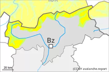
Snowpack
dp.4: cold following warm / warm following cold
dp.6: cold, loose snow and wind
Faceted weak layers exist in the top section of the snowpack, especially on north, northeast and east facing slopes between approximately 2700 and 3100 m, as well as on sunny slopes above approximately 2600 m.
Over a wide area 5 to 10 cm of snow, and even more in some localities, fell on Saturday. In the south less snow fell. As a consequence of the northerly wind, fresh snow drift accumulations will form. These are lying on soft layers in particular on very steep shady slopes at elevated altitudes.
Tendency
Easter Monday: Weakly bonded old snow at high altitude. The weather conditions will bring about a slight stabilisation of the snow drift accumulations.
Slight increase in danger of wet avalanches as a consequence of warming.