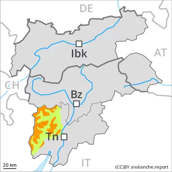
The new snow and wind slabs of the last few days must be evaluated with care and prudence.
The fresh wind slabs of the last few days can be released easily by a single winter sport participant. Avalanches can in some cases reach medium size. In high Alpine regions the avalanche prone locations are more prevalent. Avalanche prone locations are to be found in gullies and bowls, and behind abrupt changes in the terrain. The avalanche prone locations are to be found in particular on very steep shady slopes at elevated altitudes. The wind slabs are to be bypassed as far as possible. Apart from the danger of being buried, restraint should be exercised in particular in view of the danger of avalanches sweeping people along and giving rise to falls. In very isolated cases weak layers exist in the old snowpack in particular on shady slopes. This applies on very steep slopes above approximately 2200 m.
Snowpack
dp.6: cold, loose snow and wind
Over a wide area 15 to 40 cm of snow, and even more in some localities, will fall until the evening above approximately 1800 m. The fresh and older wind slabs are barely recognisable because of the poor visibility. In some places new snow is lying on soft layers. The fresh snow as well as the wind slabs to be found in particular above approximately 1800 m can be released easily, or, in isolated cases naturally. In very isolated cases weak layers exist in the old snowpack in particular on shady slopes. This applies on very steep slopes above approximately 2200 m. In particular below the tree line only a little snow is lying.
Tendency
In some regions 10 to 20 cm of snow, and even more in some localities, will fall on Friday above approximately 1800 m. In addition further wind slabs will form in particular adjacent to ridgelines and in gullies and bowls during the night. Increase in avalanche danger as a consequence of the precipitation.
Danger level
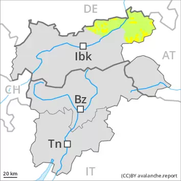
2200m
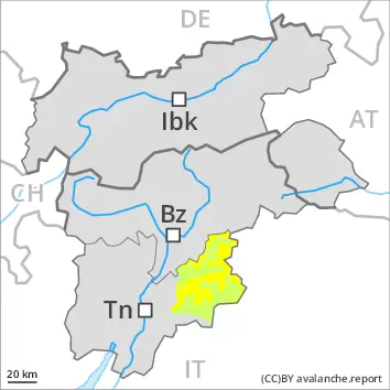
Avalanche Problem
New snow
2200m
Persistent weak layer
2400m
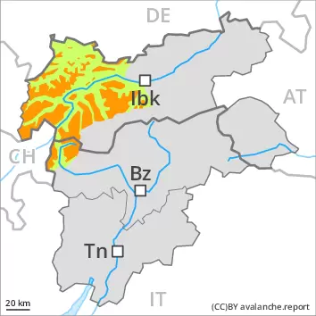
As a consequence of the new snow there will be an increase in the avalanche danger. Weakly bonded old snow is to be avoided.
The new snow can be released by a single winter sport participant. The avalanche prone locations are to be found in particular on steep shady slopes. At high altitudes and in high Alpine regions the avalanche prone locations are present in all aspects. The number and size of avalanche prone locations will increase with altitude. These avalanche prone locations are sometimes covered with new snow and are difficult to recognise. As a consequence of the new snow individual small and, in isolated cases, medium-sized loose snow avalanches are possible. In isolated cases avalanches can also release deeper layers of the snowpack and reach large size, especially on very steep west, north and east facing slopes above approximately 2400 m. Evening: As the snowfall level rises natural avalanches are possible below approximately 2400 m.
Snowpack
dp.6: cold, loose snow and wind dp.4: cold following warm / warm following cold
Up to 20 cm of snow will fall on Thursday. In some places new snow is lying on soft layers. Faceted weak layers exist in the old snowpack on very steep west, north and east facing slopes, especially above approximately 2400 m on the Main Alpine Ridge.
Tendency
Hardly any decrease in danger. Some snow will fall.
Danger level
2200m
Avalanche Problem
New snow
2200m
Persistent weak layer
2400m
As a consequence of the new snow there will be an increase in the avalanche danger. Weakly bonded old snow is to be avoided.
The new snow can be released by a single winter sport participant. The avalanche prone locations are to be found in particular on steep shady slopes. At high altitudes and in high Alpine regions the avalanche prone locations are present in all aspects. The number and size of avalanche prone locations will increase with altitude. These avalanche prone locations are sometimes covered with new snow and are difficult to recognise. As a consequence of the new snow individual small and, in isolated cases, medium-sized loose snow avalanches are possible. In isolated cases avalanches can also release deeper layers of the snowpack and reach large size, especially on very steep west, north and east facing slopes above approximately 2400 m. Evening: As the snowfall level rises natural avalanches are possible below approximately 2400 m.
Snowpack
dp.6: cold, loose snow and wind dp.4: cold following warm / warm following cold
20 to 30 cm of snow, and up to 40 cm in some localities, will fall on Thursday. In some places new snow is lying on soft layers. Faceted weak layers exist in the old snowpack on very steep west, north and east facing slopes, especially above approximately 2400 m on the Main Alpine Ridge.
Tendency
Hardly any decrease in danger. Some snow will fall.
Danger level
treeline
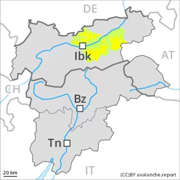
Avalanche Problem
Wind slab
Treeline
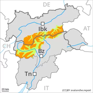
Fresh wind slabs require caution.
The fresh wind slabs can be released in isolated cases in particular on steep shady slopes above the tree line. In very isolated cases avalanches are medium-sized. Apart from the danger of being buried, restraint should be exercised in particular in view of the danger of avalanches sweeping people along and giving rise to falls.
Snowpack
dp.6: cold, loose snow and wind
5 to 15 cm of snow, and even more in some localities, will fall on Thursday. In isolated cases wind slabs are lying on soft layers, in particular on steep shady slopes at elevated altitudes. At low and intermediate altitudes only a little snow is now lying.
Tendency
Slight increase in avalanche danger as a consequence of the snowfall.
Danger level
treeline
Avalanche Problem
Wind slab
Treeline
The new snow and wind slabs of the last few days must be evaluated with care and prudence.
Avalanches can in some places be released, even by a single winter sport participant and reach medium size. The avalanche prone locations are to be found in particular on steep shady slopes and in gullies and bowls, and behind abrupt changes in the terrain. The number and size of avalanche prone locations will increase with altitude. Isolated small and medium-sized loose snow avalanches are possible as a consequence of the new snow. In isolated cases avalanches can also release deeper layers of the snowpack, especially on very steep west, north and east facing slopes above approximately 2200 m.
Snowpack
Over a wide area 10 to 20 cm of snow, and even more in some localities, will fall until the evening above approximately 1800 m. In some places new snow is lying on soft layers. The fresh and older wind slabs are barely recognisable because of the poor visibility. In very isolated cases weak layers exist in the old snowpack in particular on shady slopes. This applies on very steep slopes above approximately 2200 m. In particular below the tree line only a little snow is lying.
Tendency
Over a wide area 5 to 20 cm of snow will fall on Friday above approximately 1800 m. In addition further wind slabs will form in particular adjacent to ridgelines and in gullies and bowls during the night. Slight increase in avalanche danger as a consequence of the precipitation.
Danger level
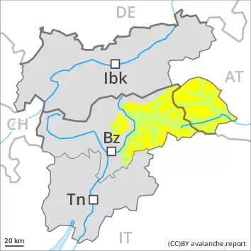
2200m
Avalanche Problem
Wind slab
2200m
Persistent weak layer
2400m
As a consequence of the new snow there will be an increase in the avalanche danger. Weakly bonded old snow is to be avoided.
The new snow can be released by a single winter sport participant. The avalanche prone locations are to be found in particular on steep shady slopes and in gullies and bowls, and behind abrupt changes in the terrain. The number and size of avalanche prone locations will increase with altitude. These avalanche prone locations are sometimes covered with new snow and are difficult to recognise. In isolated cases avalanches can also release deeper layers of the snowpack and reach large size, especially on very steep west, north and east facing slopes above approximately 2400 m.
Snowpack
dp.6: cold, loose snow and wind dp.4: cold following warm / warm following cold
Up to 20 cm of snow will fall on Thursday. In some places new snow is lying on a weakly bonded old snowpack. Faceted weak layers exist in the old snowpack on very steep west, north and east facing slopes, especially above approximately 2400 m on the Main Alpine Ridge.
Tendency
Hardly any decrease in danger.
Danger level
treeline
Avalanche Problem
Wind slab
Treeline
New snow and wind slabs require caution.
The fresh wind slabs can be released in isolated cases. The avalanche prone locations are to be found in particular on very steep shady slopes at elevated altitudes, especially at transitions into gullies and bowls. Mostly avalanches are only small. Apart from the danger of being buried, restraint should be exercised in particular in view of the danger of avalanches sweeping people along and giving rise to falls.
Snowpack
dp.6: cold, loose snow and wind
The fresh snow as well as the wind slabs to be found in particular above approximately 2000 m can be released easily, or, in isolated cases naturally. Soft wind slabs can be released easily especially at their margins. The fresh and older wind slabs are barely recognisable because of the poor visibility. In isolated cases wind slabs are lying on soft layers, in particular on steep shady slopes at elevated altitudes. In particular below the tree line only a little snow is lying.
Tendency
Over a wide area wind and new snow above approximately 1800 m. Slight increase in avalanche danger as a consequence of the snowfall.
Danger level
treeline
Avalanche Problem
Wind slab
Treeline
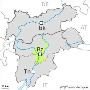
As a consequence of new snow and wind there will be an increase in the avalanche danger.
Avalanches can in some places be released, even by a single winter sport participant and reach medium size. The avalanche prone locations are to be found in particular on steep shady slopes and in gullies and bowls, and behind abrupt changes in the terrain. The number and size of avalanche prone locations will increase with altitude. Isolated small and medium-sized loose snow avalanches are possible as a consequence of the new snow. In isolated cases avalanches can also release deeper layers of the snowpack, especially on very steep west, north and east facing slopes above approximately 2400 m.
Snowpack
dp.6: cold, loose snow and wind
10 to 20 cm of snow will fall on Thursday. In some places new snow is lying on soft layers. Faceted weak layers exist in the old snowpack on very steep west, north and east facing slopes, especially above approximately 2400 m on the Main Alpine Ridge.
Tendency
Hardly any decrease in danger. Some snow will fall.
Danger level
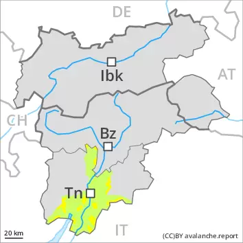
1600m
Avalanche Problem
Wind slab
1600m
Fresh wind slabs are to be avoided.
The fresh wind slabs can be released by a single winter sport participant in isolated cases. The avalanche prone locations are to be found in particular on very steep shady slopes above approximately 1600 m, especially at transitions into gullies and bowls. In very isolated cases avalanches are medium-sized.
Snowpack
dp.6: cold, loose snow and wind
The snowpack will be quite well bonded. In isolated cases wind slabs are lying on soft layers, in particular on steep shady slopes. At low altitude only a little snow is now lying.