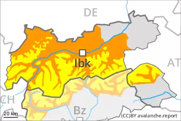
An unfavourable avalanche situation will be encountered over a wide area. Weakly bonded old snow and wet snow are to be critically assessed.
As a consequence of the moist air more frequent wet avalanches are to be expected. This applies in all aspects below approximately 2600 m. Wet avalanches can also release deeper layers of the snowpack and reach large size in isolated cases, especially on steep north facing slopes at high altitude. The runout zones of large avalanches are to be treated with caution.
In some places avalanches can be triggered in the weakly bonded old snow, in particular on very steep shady slopes above approximately 2600 m. Dry avalanches can in isolated cases penetrate deep layers and reach large size. As the day progresses the likelihood of dry avalanches being released will increase.
On steep grassy slopes more gliding avalanches are possible.
Snowpack
dp.10: springtime scenario dp.4: cold following warm / warm following cold
The rain gave rise to increasing and thorough wetting of the snowpack over a wide area. Outgoing longwave radiation during the night will be severely restricted. This applies in particular in the north. On the Main Alpine Ridge and to the south a partly clear night. The surface of the snowpack will freeze very little and will soften quickly. The high temperatures will give rise to a loss of strength within the snowpack.
Avalanche prone weak layers exist in the old snowpack in particular on steep shady slopes.
Tendency
An unfavourable avalanche situation will persist.
Danger level
Avalanche Problem
Wet snow
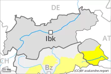
Moderate danger of wet avalanches will be encountered over a wide area.
As a consequence of warming during the day and solar radiation more frequent wet avalanches are possible from the late morning, even medium-sized ones. The avalanche prone locations are to be found on steep slopes of all aspects. Wet avalanches can in isolated cases release deeper layers of the snowpack, especially on steep north facing slopes at high altitude. As the day progresses the likelihood of avalanches being released will increase. The runout zones of avalanches are to be treated with caution.
Snowpack
dp.10: springtime scenario
The spring-like weather conditions gave rise to increasing and thorough wetting of the snowpack over a wide area. Outgoing longwave radiation during the night will be quite good. The surface of the snowpack will soften quickly. The high temperatures will give rise to a loss of strength within the snowpack.
Tendency
Moderate danger of wet avalanches will be encountered over a wide area.
Danger level
Avalanche Problem
Wet snow
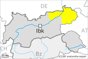
Moderate danger of wet avalanches will be encountered over a wide area.
Wet avalanches can in some places be released by people and reach medium size. The avalanche prone locations are to be found on steep slopes of all aspects above approximately 2000 m. As the day progresses the likelihood of avalanches being released will increase.
Snowpack
dp.10: springtime scenario
The spring-like weather conditions gave rise to increasing and thorough wetting of the snowpack over a wide area. Outgoing longwave radiation during the night will be severely restricted. The surface of the snowpack is hardly frozen at all will soften quickly. The high temperatures will give rise to a loss of strength within the snowpack.
Tendency
Moderate danger of wet avalanches will be encountered over a wide area.