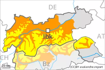
Considerable danger of wet avalanches will prevail. Weakly bonded old snow is to be evaluated with care and prudence.
As a consequence of warming more frequent wet avalanches are to be expected from the early morning. This applies in all aspects below approximately 2600 m. Wet avalanches can also release deeper layers of the snowpack and reach large size in isolated cases, especially on steep north facing slopes at high altitude. The runout zones of large avalanches are to be treated with caution.
In some places avalanches can be triggered in the weakly bonded old snow, in particular on very steep shady slopes above approximately 2600 m. Dry avalanches can in isolated cases penetrate deep layers and reach large size. As a consequence of warming, the likelihood of dry avalanches being released will increase. In addition the fresh wind slabs should be taken into account. Caution is to be exercised in particular adjacent to ridgelines at elevated altitudes.
Snowpack
dp.10: springtime scenario dp.4: cold following warm / warm following cold
The rain gave rise on Friday to increasing and thorough wetting of the snowpack over a wide area. Outgoing longwave radiation during the night will be severely restricted. The surface of the snowpack will freeze very little and will soften quickly. The high temperatures will give rise to a loss of strength within the snowpack.
Avalanche prone weak layers exist in the top section of the snowpack in particular on steep shady slopes. The fresh wind slabs are in some cases prone to triggering at elevated altitudes.
Tendency
Slight decrease in danger of wet avalanches.
Danger level
Avalanche Problem
Wet snow
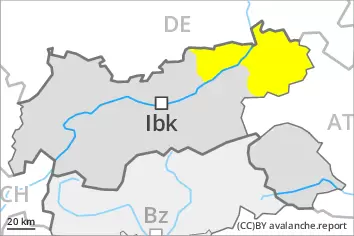
Moderate danger of wet avalanches will be encountered over a wide area.
As a consequence of warming more frequent wet avalanches are to be expected from the early morning, even medium-sized ones. The avalanche prone locations are to be found on steep slopes of all aspects. Wet avalanches can also release deeper layers of the snowpack, especially on steep north facing slopes at high altitude. The runout zones of avalanches are to be treated with caution.
Snowpack
dp.10: springtime scenario
The rain gave rise on Friday to increasing and thorough wetting of the snowpack over a wide area. Outgoing longwave radiation during the night will be reduced. The surface of the snowpack will freeze very little and will soften quickly. The high temperatures will give rise to a loss of strength within the snowpack.
Tendency
Moderate danger of wet avalanches will be encountered over a wide area.
Danger level
Avalanche Problem
Wet snow
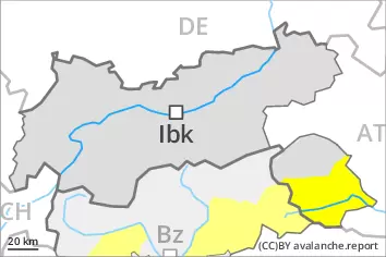
Moderate danger of wet avalanches will be encountered over a wide area.
As a consequence of warming more frequent wet avalanches are to be expected from the early morning, even medium-sized ones. The avalanche prone locations are to be found on steep slopes of all aspects. Wet avalanches can also release deeper layers of the snowpack, especially on steep north facing slopes at high altitude. The runout zones of avalanches are to be treated with caution.
Snowpack
dp.10: springtime scenario
The rain gave rise on Friday to increasing and thorough wetting of the snowpack over a wide area. Outgoing longwave radiation during the night will be reduced. The surface of the snowpack will freeze very little and will soften quickly. The high temperatures will give rise to a loss of strength within the snowpack.
Tendency
Moderate danger of wet avalanches will be encountered over a wide area.