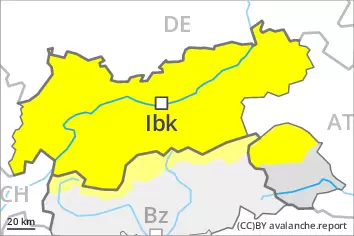
Wind slabs and weakly bonded old snow are to be assessed with care and prudence. Wet snow requires caution.
In isolated cases avalanches can be triggered in the weakly bonded old snow and reach large size in isolated cases, in particular on very steep shady slopes above approximately 2400 m. In addition the various wind slabs of the last few days are capable of being triggered in some locations. They are to be evaluated with care and prudence in particular on northwest to north to northeast facing aspects above approximately 2600 m. Avalanches can in isolated cases penetrate deep layers. At elevated altitudes the avalanche prone locations are more prevalent.
As a consequence of the rain more frequent wet avalanches are to be expected, even medium-sized ones. In particular on north facing slopes avalanches can release the weakly bonded old snow as well and reach large size in isolated cases.
Snowpack
dp.4: cold following warm / warm following cold dp.3: rain
At elevated altitudes in some regions up to 10 cm of snow will fall. The various wind slabs are in some cases still prone to triggering especially on northeast, north and northwest facing slopes above approximately 2600 m.
Avalanche prone weak layers exist in the top section of the snowpack in particular on steep shady slopes.
Outgoing longwave radiation during the night will be severely restricted over a wide area. The surface of the snowpack will freeze very little and will soften quickly. The rain will give rise to a loss of strength within the snowpack.
Tendency
On Saturday it will be very mild. Rapid increase in danger of wet avalanches as a consequence of warming during the day and solar radiation.
Danger level
2600m
Avalanche Problem
Wind slab
2600m
Wet snow
2400m
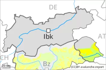
Wind slabs are to be evaluated with care and prudence. Wet snow requires caution.
Wind slabs are mostly only small but in some cases prone to triggering, in particular on very steep northwest, north and northeast facing slopes above approximately 2600 m. At elevated altitudes the avalanche prone locations are more prevalent. In very isolated cases avalanches can also penetrate deep layers.
As the moisture increases more frequent wet avalanches are to be expected. This applies in all aspects below approximately 2400 m. In particular on north facing slopes avalanches can release the weakly bonded old snow as well and reach quite a large size.
Snowpack
dp.4: cold following warm / warm following cold dp.3: rain
The various wind slabs are in some cases still prone to triggering in particular on very steep northwest, north and northeast facing slopes above approximately 2600 m.
Isolated avalanche prone weak layers exist in the top section of the snowpack in particular on steep shady slopes.
Outgoing longwave radiation during the night will be severely restricted over a wide area. The surface of the snowpack will freeze very little and will soften quickly. The weather conditions will give rise to increasing and thorough wetting of the snowpack.
Tendency
On Saturday it will be very mild. Rapid increase in danger of wet avalanches as a consequence of warming during the day and solar radiation.