Weakly bonded old snow is to be evaluated with care and prudence. Wind slabs require caution.
In isolated cases avalanches can be triggered in the weakly bonded old snow and reach large size in isolated cases, in particular on very steep shady slopes above approximately 2400 m. In addition the various wind slabs of the last few days are capable of being triggered in some locations. They are to be evaluated with care and prudence in particular on northwest to north to northeast facing aspects above approximately 2600 m. Avalanches can in isolated cases penetrate deep layers. At elevated altitudes the avalanche prone locations are more prevalent.
As the moisture increases more frequent wet avalanches are possible, even medium-sized ones.
Snowpack
dp.4: cold following warm / warm following cold dp.6: cold, loose snow and wind
As a consequence of new snow and a moderate to strong northwesterly wind, sometimes large wind slabs formed in the last few days. These are lying on soft layers in particular on northwest to north to northeast facing aspects above approximately 2600 m.
Avalanche prone weak layers exist in the top section of the snowpack in particular on steep shady slopes.
Outgoing longwave radiation during the night will be severely restricted over a wide area. The surface of the snowpack will freeze very little and will soften during the day.
Tendency
On Friday it will be mild. Some rain will fall over a wide area, especially in the north. Increase in danger of wet avalanches.
Danger level
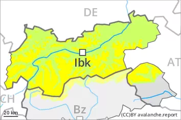
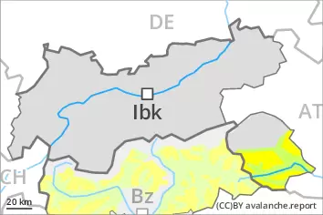
2400m
Avalanche Problem
Persistent weak layer
2400m
Wind slab
2600m
Wind slabs and weakly bonded old snow are to be assessed with care and prudence.
Weak layers in the old snowpack can still be released in isolated cases by individual winter sport participants in particular on very steep shady slopes, especially above approximately 2400 m. In addition the various wind slabs of the last few days are capable of being triggered in some cases still, in particular on very steep northwest, north and northeast facing slopes above approximately 2600 m. At elevated altitudes the avalanche prone locations are more prevalent. In isolated cases avalanches can also penetrate deep layers.
As a consequence of warming during the day and solar radiation wet avalanches are possible as the day progresses, even medium-sized ones.
Snowpack
dp.4: cold following warm / warm following cold dp.6: cold, loose snow and wind
The various wind slabs are in some cases still prone to triggering in particular on very steep northwest, north and northeast facing slopes above approximately 2600 m. Isolated avalanche prone weak layers exist in the top section of the snowpack in particular on steep shady slopes.
Outgoing longwave radiation during the night will be quite good over a wide area. The surface of the snowpack will freeze to form a strong crust. Sunshine and high temperatures will give rise as the day progresses to increasing moistening of the snowpack.
Tendency
On Friday it will be mild. Increase in danger of wet avalanches in the course of the day.