Weakly bonded old snow represents the main danger. Wind slabs are to be evaluated with care and prudence.
In some places avalanches can be triggered in the weakly bonded old snow and reach large size in isolated cases, in particular on very steep shady slopes above approximately 2400 m. In addition the various wind slabs of the last few days are capable of being triggered in some cases still. They are to be evaluated with care and prudence in particular on northwest to north to east facing aspects above approximately 2400 m. Avalanches can penetrate deep layers. At elevated altitudes the avalanche prone locations are more prevalent.
As the day progresses as a consequence of solar radiation there will be a gradual increase in the danger of wet avalanches.
Snowpack
dp.4: cold following warm / warm following cold dp.6: cold, loose snow and wind
In some regions 10 to 30 cm of snow, and even more in some localities, has fallen since Monday. As a consequence of new snow and a moderate to strong northwesterly wind, sometimes large wind slabs formed. These are lying on soft layers in particular on northwest to north to east facing aspects above approximately 2400 m. Avalanche prone weak layers exist in the top section of the snowpack in particular on steep shady slopes.
The weather conditions as the day progresses will give rise to increasing moistening of the snowpack.
Tendency
The meteorological conditions will facilitate a slow stabilisation of the snowpack. Increase in danger of moist and wet avalanches as a consequence of warming.
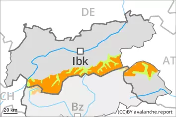
Danger level
2400m
Avalanche Problem
Persistent weak layer
2400m
Wind slab
2400m
Weakly bonded old snow is to be evaluated with care and prudence. Fresh wind slabs require caution.
Weak layers in the old snowpack can be released in some places even by individual winter sport participants in particular on very steep shady slopes, especially above approximately 2400 m.
In addition the various wind slabs of the last few days are capable of being triggered in some cases still. In isolated cases avalanches can also penetrate deep layers and reach large size, in particular on very steep northwest, north and east facing slopes above approximately 2400 m. At elevated altitudes the avalanche prone locations are more prevalent.
As the day progresses as a consequence of solar radiation there will be a gradual increase in the danger of wet avalanches.
Snowpack
dp.4: cold following warm / warm following cold dp.6: cold, loose snow and wind
In some regions 10 to 30 cm of snow, and even more in some localities, has fallen since Monday. As a consequence of new snow and a moderate to strong northwesterly wind, sometimes large wind slabs formed.
Avalanche prone weak layers exist in the top section of the snowpack in particular on steep shady slopes.
The weather conditions as the day progresses will give rise to increasing moistening of the snowpack.
Tendency
The conditions will facilitate a settling of the snowpack. Slight increase in danger of moist and wet avalanches as a consequence of warming.
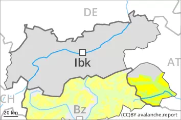
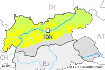