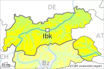
Danger level
 | treeline |
|  |
|  |

![]()
Slight increase in avalanche danger in the course of the day. Fresh wind slabs require caution.
As a consequence of new snow and a strengthening wind, sometimes avalanche prone wind slabs will form in the afternoon above the tree line. Caution is to be exercised in particular adjacent to ridgelines in gullies and bowls, and behind abrupt changes in the terrain. The avalanche prone locations are barely recognisable because of the poor visibility.
In addition a latent danger of gliding avalanches exists, in particular on steep east, south and west facing slopes below approximately 2600 m. In isolated cases the gliding avalanches are quite large. This applies in the regions with a lot of snow. Caution is to be exercised in areas with glide cracks.
Snowpack
dp.6: cold, loose snow and wind
dp.2: gliding snow
Over a wide area 10 to 30 cm of snow will fall. Afternoon: The wind will be moderate in some regions. The fresh wind slabs are lying on soft layers at elevated altitudes. They can in some cases be released easily.
The new snow will be deposited on surface hoar in some places in areas close to the tree line. The new snow of the last few days is lying on a crust in all aspects below approximately 2600 m. The old snowpack will be stable over a wide area.
Tendency
Increase in avalanche danger as a consequence of new snow and wind. Over a wide area 20 to 40 cm of snow, and even more in some localities, will fall until Sunday above approximately 1000 m. The fresh wind slabs can be released easily.