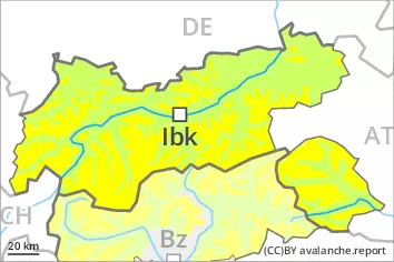
Danger level
 | 2200m |
|  |
|  |

![]()
Fresh wind slabs represent the main danger.
As a consequence of the occasionally strong wind, fresh snow drift accumulations will form. These are prone to triggering at elevated altitudes. Caution is to be exercised in particular adjacent to ridgelines in gullies and bowls, and behind abrupt changes in the terrain above approximately 2200 m. The number and size of avalanche prone locations will increase with altitude. These avalanche prone locations are easy to recognise.
In addition a latent danger of gliding avalanches exists, in particular on steep east, south and west facing slopes below approximately 2600 m. Gliding avalanches can be released at any time of day or night. In isolated cases they are quite large. This applies in the regions with a lot of snow. Caution is to be exercised in areas with glide cracks.
Snowpack
dp.6: cold, loose snow and wind
dp.2: gliding snow
Friday: Evening and night: Over a wide area 10 to 20 cm of snow will fall. The wind will be moderate to strong over a wide area. The fresh wind slabs are lying on soft layers at elevated altitudes. The fresh wind slabs can in some cases be released easily.
The new snow is lying on a crust in all aspects below approximately 2600 m. Low and intermediate altitudes: The old snowpack is fairly homogeneous and its surface has a melt-freeze crust that is strong in many cases. This also applies on steep sunny slopes at high altitude.
The old snowpack will be stable over a wide area.
Tendency
Over a wide area 20 to 40 cm of snow will fall until Sunday above approximately 1000 m. Slight increase in avalanche danger as a consequence of new snow and wind. Fresh wind slabs require caution.
A latent danger of gliding avalanches exists.