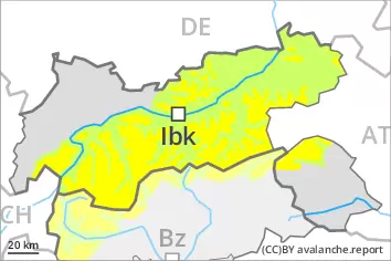
Wind slabs represent the main danger. Gliding avalanches and loose snow slides are possible.
The fresh wind slabs can be released easily in some cases above approximately 2200 m. Avalanche prone locations are to be found in gullies and bowls, and behind abrupt changes in the terrain. The prevalence of avalanche prone locations and likelihood of triggering will increase with altitude. In the regions exposed to heavier precipitation the danger is higher. Avalanches can reach medium size.
Gliding avalanches are possible, even large ones in isolated cases, in particular on steep east, south and west facing slopes below approximately 2600 m. Areas with glide cracks are to be avoided.
Afternoon: On extremely steep slopes small and, in isolated cases, medium-sized wet loose snow avalanches are possible as a consequence of the rain.
Snowpack
dp.6: cold, loose snow and wind dp.2: gliding snow
15 to 25 cm of snow has fallen since Monday, in particular in the Lechtal Alps and in the Allgäu Alps. Wednesday: Some snow will fall. Up to high altitudes rain will fall. The storm force wind will transport the fresh and old snow significantly. The fresh wind slabs are in some cases prone to triggering. Towards its base, the snowpack is largely stable. In particular above the tree line snow depths vary greatly, depending on the infuence of the wind. The weather conditions will give rise to significant moistening of the snowpack especially at low and intermediate altitudes.
Tendency
Thursday: 10 to 15 cm of snow, and even more in some localities, will fall. As a consequence of the strong wind, fresh snow drift accumulations will form.
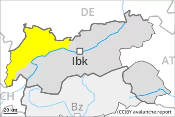
Danger level
2400m
Avalanche Problem
Wind slab
2400m
Wind slabs are mostly small but in some cases prone to triggering.
More recent wind slabs can still be released in some cases in particular on northwest to north to east facing aspects above approximately 2400 m. The avalanche prone locations are to be found in particular adjacent to ridgelines and in pass areas and in gullies and bowls. At elevated altitudes the likelihood of avalanches being released is greater. The wind slabs are clearly recognisable to the trained eye. Mostly avalanches are only small. Even a small avalanche can sweep winter sport participants along and give rise to falls.
Snowpack
dp.6: cold, loose snow and wind
The fresh wind slabs are in some cases still prone to triggering at elevated altitudes. Towards its base, the snowpack consists of faceted crystals. The snowpack will be subject to considerable local variations above the tree line. Sunshine and high temperatures will give rise as the day progresses to significant moistening of the snowpack at low and intermediate altitudes, this also applies on steep sunny slopes.
Tendency
As a consequence of mild temperatures the snow drift accumulations stabilised on Wednesday. These conditions will bring about a decrease in the danger of dry avalanches.
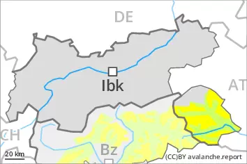
Danger level
2200m
Avalanche Problem
Wind slab
2200m
Gliding snow
2600m
Wind slabs represent the main danger.
As a consequence of new snow and a sometimes storm force wind from northwesterly directions, mostly small wind slabs will form on north and east facing slopes. Avalanche prone locations are to be found in gullies and bowls, and behind abrupt changes in the terrain above approximately 2200 m. At elevated altitudes the avalanche prone locations are a little more prevalent and exist in all aspects. The avalanche prone locations are and are barely recognisable because of the poor visibility. Apart from the danger of being buried, restraint should be exercised as well in view of the danger of avalanches sweeping people along and giving rise to falls.
More gliding avalanches are possible, even large ones in isolated cases, in particular on steep east, south and west facing slopes below approximately 2600 m, in particular in the regions with a lot of snow. Areas with glide cracks are to be avoided. On extremely steep slopes individual mostly small wet loose snow avalanches are possible as a consequence of warming.
Snowpack
dp.6: cold, loose snow and wind dp.2: gliding snow
North of the Inn 5 to 15 cm of snow has fallen since Monday. Less snow than expected has fallen in the other regions. Up to 5 cm of snow will fall until the early morning. Up to high altitudes rain will fall. The storm force wind will transport the fresh and old snow. The fresh wind slabs are in some cases prone to triggering. Towards its base, the snowpack is largely stable. Above the tree line snow depths vary greatly, depending on the infuence of the wind. The weather conditions will give rise to significant moistening of the snowpack especially at low and intermediate altitudes.
Tendency
10 to 15 cm of snow, and even more in some localities, will fall. As a consequence of snowfall and the strong northwesterly wind, fresh snow drift accumulations will form.