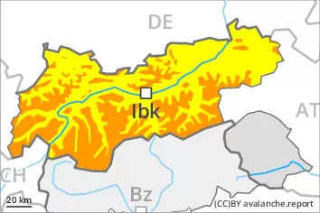
The backcountry touring conditions are precarious.
As a consequence of new snow and a strong to storm force wind from northwesterly directions, extensive wind slabs will form. Avalanche prone locations are to be found on wind-loaded slopes and adjacent to ridgelines and in gullies and bowls in all aspects. The prevalence of avalanche prone locations and likelihood of triggering will increase with altitude. The avalanche prone locations are quite prevalent and are barely recognisable because of the poor visibility. At the base of rock walls and behind abrupt changes in the terrain individual medium-sized to large natural avalanches are possible, especially in case of releases originating from very steep high-altitude and leeward starting zones.
Gliding avalanches are possible, even large ones in isolated cases. This applies in particular in all aspects below approximately 2600 m. Areas with glide cracks are to be avoided. On extremely steep slopes small and, in isolated cases, medium-sized wet loose snow avalanches are possible as a consequence of the rain.
Snowpack
dp.6: cold, loose snow and wind dp.2: gliding snow
Over a wide area 40 to 60 cm of snow, and even more in some localities, will fall until the evening. Up to intermediate altitudes rain will fall.
High altitudes and the high Alpine regions: The northwesterly wind will transport the new snow significantly. Avalanche prone weak layers exist in the top section of the snowpack. The new snow and wind slabs are lying on the unfavourable surface of an old snowpack. Towards its base, the snowpack is largely stable. Low and intermediate altitudes: The rain will give rise to a loss of strength within the snowpack.
Tendency
As the snowfall eases there will be a decrease in the danger of dry avalanches within the current danger level. 5 to 10 cm of snow, and even more in some localities, will fall. The wind will be strong in some cases.
Danger level
2200m
Avalanche Problem
Wind slab
2200m
Gliding snow
2600m
Wet snow
Treeline
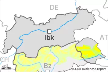
The backcountry and freeriding conditions are to some extent unfavourable.
As a consequence of new snow and a strong wind from northwesterly directions, extensive wind slabs will form above the tree line. Avalanche prone locations are to be found on wind-loaded slopes and adjacent to ridgelines and in gullies and bowls. As a consequence of the snowfall the prevalence and size of the avalanche prone locations will increase as the day progresses. At elevated altitudes the likelihood of avalanches being released is greater. Individual medium-sized natural avalanches are not ruled out. This applies in the regions exposed to heavier precipitation, in particular in case of releases originating from very steep high-altitude and leeward starting zones.
As a consequence of the precipitation more frequent gliding avalanches are possible, even large ones in isolated cases. This applies in particular in all aspects below approximately 2600 m. Areas with glide cracks are to be avoided. On extremely steep slopes small and, in isolated cases, medium-sized wet loose snow avalanches are to be expected as a consequence of the rain.
Snowpack
dp.6: cold, loose snow and wind dp.2: gliding snow
Over a wide area 20 to 40 cm of snow will fall on Thursday. Up to the tree line rain will fall in some regions. This applies in particular in the west. In the east the snowfall level will be lower.
High altitudes and the high Alpine regions: The northwesterly wind will transport the new snow significantly. Avalanche prone weak layers exist in the top section of the snowpack. The new snow and wind slabs are lying on the unfavourable surface of an old snowpack. Towards its base, the snowpack is largely stable. Low and intermediate altitudes: The rain will give rise to a loss of strength within the snowpack.
Tendency
Friday: The snowpack remains prone to triggering. 5 to 15 cm of snow, and even more in some localities, will fall, especially in the northwest. The wind will be strong in some cases.
Danger level
2200m
Avalanche Problem
Wind slab
2200m
Gliding snow
2600m
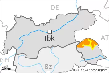
Wind slabs represent the main danger.
As a consequence of new snow and a sometimes storm force wind from northwesterly directions, sometimes avalanche prone wind slabs will form on north and east facing slopes. Avalanche prone locations are to be found in gullies and bowls, and behind abrupt changes in the terrain above approximately 2200 m. At elevated altitudes the avalanche prone locations are a little more prevalent and exist in all aspects. The avalanche prone locations are and are barely recognisable because of the poor visibility. Avalanches can in particular reach medium size in isolated cases in the regions neighbouring those that are subject to danger level 3 (considerable).
More gliding avalanches are possible, even large ones in isolated cases, in particular on steep east, south and west facing slopes below approximately 2600 m, in particular in the regions with a lot of snow. Areas with glide cracks are to be avoided. On extremely steep slopes individual mostly small wet loose snow avalanches are possible as a consequence of the rain.
Snowpack
dp.6: cold, loose snow and wind dp.2: gliding snow
Over a wide area 5 to 15 cm of snow, and up to 20 cm in some localities, will fall on Thursday. Up to intermediate altitudes rain will fall.
High altitudes and the high Alpine regions: The northwesterly wind will transport the new snow and, in some cases, old snow as well. The fresh wind slabs will be deposited on soft layers at elevated altitudes. They are in some cases prone to triggering. Towards its base, the snowpack consists of faceted crystals. The snowpack will be subject to considerable local variations above the tree line.
Low and intermediate altitudes: The rain will give rise to a loss of strength within the snowpack.
Tendency
Some snow will fall. Wind slabs represent the main danger.
Danger level
2400m
Avalanche Problem
Wind slab
2400m
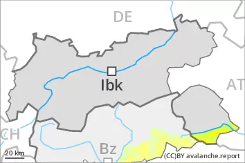
Wind slabs are only small and can only be released by large loads in most cases.
The small wind slabs of the last few days can be released in isolated cases on very steep shady slopes above approximately 2400 m. The wind slabs are clearly recognisable to the trained eye. Restraint should be exercised because avalanches can sweep people along and give rise to falls.
Snowpack
As a consequence of mild temperatures and solar radiation the snow drift accumulations stabilised. The snowpack will be generally stable. Towards its base, the snowpack consists of faceted crystals. The snowpack will be subject to considerable local variations above the tree line.