Fresh wind slabs require caution. Gliding avalanches and wet snow slides are possible.
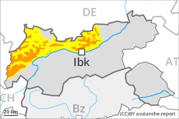
As a consequence of new snow and a strong wind from northwesterly directions, extensive wind slabs formed above the tree line. In the course of the day the wind slabs will increase in size additionally. Even single winter sport participants can release avalanches in many places, including medium-sized ones. Avalanche prone locations are to be found on wind-loaded slopes and adjacent to ridgelines and in gullies and bowls. At elevated altitudes the likelihood of avalanches being released is greater.
More gliding avalanches are possible, even large ones in isolated cases. This applies on steep grassy slopes below approximately 2600 m. Areas with glide cracks are to be avoided. On extremely steep slopes small and medium-sized loose snow avalanches are to be expected as a consequence of warming during the day and solar radiation.
Snowpack
dp.6: cold, loose snow and wind dp.2: gliding snow
30 to 50 cm of snow, and even more in some localities, has fallen above approximately 2200 m. 5 to 15 cm of snow, and even more in some localities, will fall on Friday. Up to intermediate altitudes rain will fall in some regions.
The northwesterly wind will transport the new snow. Avalanche prone weak layers exist in the top section of the snowpack. The new snow and wind slabs are lying on the unfavourable surface of an old snowpack. Towards its base, the snowpack is largely stable. Low and intermediate altitudes: The high temperatures will give rise to significant moistening of the snowpack.
Tendency
Wind slabs and gliding snow represent the main danger.
Danger level
2200m
Avalanche Problem
Wind slab
2200m
Gliding snow
2600m
Fresh wind slabs require caution.
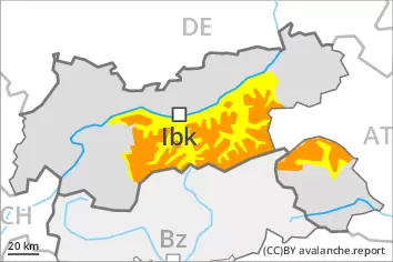
As a consequence of new snow and a strong wind from northwesterly directions, extensive wind slabs formed above the tree line. In the course of the day the wind slabs will increase in size additionally. Even single winter sport participants can release avalanches in some places, including medium-sized ones. Avalanche prone locations are to be found on wind-loaded slopes and adjacent to ridgelines and in gullies and bowls. At elevated altitudes the likelihood of avalanches being released is greater.
More gliding avalanches are possible, in particular medium-sized ones. This applies in particular on steep grassy slopes below approximately 2600 m. Areas with glide cracks are to be avoided. On extremely steep slopes small and, in isolated cases, medium-sized wet loose snow avalanches are to be expected as a consequence of warming during the day and solar radiation.
Snowpack
dp.6: cold, loose snow and wind dp.2: gliding snow
15 to 30 cm of snow, and up to 40 cm in some localities, has fallen. 5 to 10 cm of snow, and even more in some localities, will fall on Friday. Up to intermediate altitudes rain will fall in some regions.
The northwesterly wind will transport the new snow. Avalanche prone weak layers exist in the top section of the snowpack. The new snow and wind slabs are lying on the unfavourable surface of an old snowpack. Towards its base, the snowpack is largely stable. Low and intermediate altitudes: The high temperatures will give rise to significant moistening of the snowpack.
Tendency
Wind slabs and gliding snow represent the main danger.
Danger level
2200m
Avalanche Problem
Wind slab
2200m
Gliding snow
2600m
Wind slabs and gliding snow require caution.
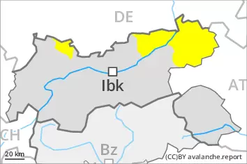
As a consequence of new snow and a sometimes strong wind from northwesterly directions, sometimes avalanche prone wind slabs formed. Avalanches can in some places be released by a single winter sport participant and reach medium size. Avalanche prone locations are to be found in gullies and bowls, and behind abrupt changes in the terrain above approximately 2200 m. At elevated altitudes the avalanche prone locations are a little more prevalent.
More gliding avalanches are possible, even quite large ones, in particular on steep grassy slopes below approximately 2600 m. Areas with glide cracks are to be avoided. On extremely steep slopes small to medium-sized loose snow avalanches are to be expected as a consequence of warming during the day and solar radiation.
Snowpack
dp.6: cold, loose snow and wind dp.2: gliding snow
10 to 15 cm of snow, and up to 20 cm in some localities, has fallen. Some snow will fall on Friday. Up to intermediate altitudes rain will fall.
The northwesterly wind will transport the new snow. Avalanche prone weak layers exist in the top section of the snowpack. The fresh wind slabs are lying on unfavourable layers at elevated altitudes. Towards its base, the snowpack is largely stable. The high temperatures will give rise to significant moistening of the snowpack.
Tendency
Wind slabs represent the main danger.
Danger level
2200m
Avalanche Problem
Wind slab
2200m
Gliding snow
Wind slabs and gliding snow require caution.
As a consequence of new snow and a sometimes strong wind from northwesterly directions, sometimes avalanche prone wind slabs formed. Avalanches can in some places be released by a single winter sport participant and reach medium size. Avalanche prone locations are to be found in gullies and bowls, and behind abrupt changes in the terrain above approximately 2200 m. At elevated altitudes the avalanche prone locations are a little more prevalent.
More gliding avalanches are possible, even quite large ones, in particular on steep grassy slopes. Areas with glide cracks are to be avoided. On extremely steep slopes small to medium-sized loose snow avalanches are to be expected as a consequence of warming during the day and solar radiation.
Snowpack
dp.6: cold, loose snow and wind dp.2: gliding snow
25 to 40 cm of snow has fallen. Some snow will fall on Friday. Up to intermediate altitudes rain will fall.
The northwesterly wind will transport the new snow. The fresh wind slabs are lying on soft layers at elevated altitudes. Towards its base, the snowpack is largely stable. The high temperatures will give rise to significant moistening of the snowpack.
Tendency
Wind slabs represent the main danger.
Danger level
2400m
Avalanche Problem
Wind slab
2400m
Gliding snow
2600m
Wind slabs and gliding snow require caution.
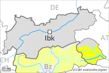
As a consequence of a sometimes strong wind from northwesterly directions, sometimes avalanche prone wind slabs will form on north and east facing slopes. Avalanche prone locations are to be found in gullies and bowls, and behind abrupt changes in the terrain above approximately 2400 m. At elevated altitudes the avalanche prone locations are a little more prevalent and exist in all aspects. Avalanches can in some cases reach medium size.
More gliding avalanches are possible, even quite large ones, in particular on steep east, south and west facing slopes below approximately 2600 m, in particular in the regions with a lot of snow. Areas with glide cracks are to be avoided. On extremely steep slopes more small to medium-sized wet loose snow avalanches are possible as a consequence of warming during the day and solar radiation.
Snowpack
dp.6: cold, loose snow and wind dp.2: gliding snow
Some snow will fall in particular in the north. Up to intermediate altitudes rain will fall.
High altitudes and the high Alpine regions: The northwesterly wind will transport the new snow and, in some cases, old snow as well. The fresh wind slabs will be deposited on soft layers at elevated altitudes. They are in some cases prone to triggering. Towards its base, the snowpack consists of faceted crystals. The snowpack will be subject to considerable local variations above the tree line.
Intermediate altitudes: Early and late morning: The snowpack is wet and its surface has a melt-freeze crust.