Wind slabs require caution. Gradual increase in danger of gliding avalanches and moist snow slides as a consequence of warming during the day and solar radiation.
More recent wind slabs can be released in isolated cases on northwest to north to east facing aspects above approximately 2400 m. The avalanche prone locations are to be found especially adjacent to ridgelines and in gullies and bowls. Avalanches can in isolated cases reach medium size.
On steep grassy slopes individual medium-sized gliding avalanches are possible below approximately 2600 m. In the course of the day the activity of gliding avalanches will gradually increase. Areas with glide cracks are to be avoided.
As a consequence of warming during the day and solar radiation mostly small wet loose snow avalanches are to be expected, especially on extremely steep sunny slopes.
Snowpack
dp.6: cold, loose snow and wind dp.2: gliding snow
Fresh wind slabs are lying on soft layers on northwest to north to east facing aspects. They are in isolated cases prone to triggering. No distinct weak layers exist in the bottom section of the snowpack. Sunshine and high temperatures will give rise to significant softening of the snowpack in particular on extremely steep sunny slopes. At low altitude only a little snow is now lying.
Tendency
The weather conditions will bring about a stabilisation of the snow drift accumulations. They are now only very rarely prone to triggering. A latent danger of gliding avalanches exists.
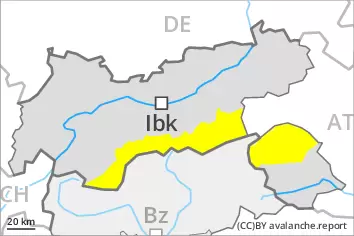
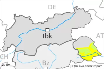
AM Danger level
2600m
Avalanche Problem
Gliding snow
2600m
Wind slab
2400m
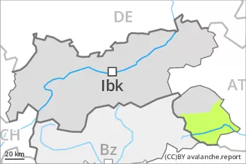
PM Danger level
2600m
Avalanche Problem
Gliding snow
2600m
Gradual increase in danger of gliding avalanches and moist snow slides as a consequence of warming during the day and solar radiation. Fresh wind slabs require caution.
On steep grassy slopes and below approximately 2600 m individual gliding avalanches are possible, in particular medium-sized ones. This applies especially in the regions with a lot of snow. In the course of the day the activity of gliding avalanches will increase. Areas with glide cracks are to be avoided. As a consequence of warming during the day and solar radiation mostly small wet loose snow avalanches are to be expected, especially on extremely steep sunny slopes.
The small wind slabs of the last few days can be released by a single winter sport participant in isolated cases. Avalanche prone locations are to be found on very steep northwest, north and east facing slopes above approximately 2400 m. The wind slabs are to be avoided especially in terrain where there is a danger of falling.
Snowpack
dp.2: gliding snow dp.6: cold, loose snow and wind
Sunshine and high temperatures will give rise as the day progresses to increasing softening of the snowpack.
The mostly small wind slabs of the last few days are in individual cases still prone to triggering. They are lying on soft layers on northwest to north to east facing aspects. No distinct weak layers exist in the bottom section of the snowpack.
Tendency
The weather will be exceptionally warm. Gliding snow represents the main danger.
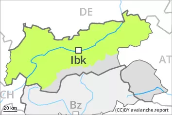
AM Danger level
2400m
Avalanche Problem
Wind slab
2400m
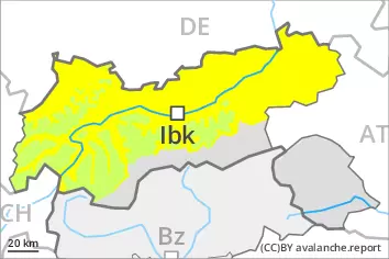
PM Danger level
2600m
Avalanche Problem
Wet snow
2600m
Wind slab
2400m
Fresh wind slabs require caution. As the day progresses wet loose snow slides are to be expected.
The more recent wind slabs can be released by a single winter sport participant in isolated cases in particular on steep shady slopes. Avalanche prone locations are to be found in particular adjacent to ridgelines and in gullies and bowls. Mostly avalanches are small.
As a consequence of warming during the day and solar radiation wet loose snow slides are to be expected below approximately 2600 m. This applies in particular on extremely steep sunny slopes.
Snowpack
dp.6: cold, loose snow and wind dp.10: springtime scenario
The wind slabs are lying on soft layers on shady slopes at high altitudes and in high Alpine regions.
Sunshine and high temperatures will give rise as the day progresses to increasing softening of the snowpack over a wide area in particular on steep sunny slopes. These conditions will cause a weakening of the near-surface layers as the day progresses.
Towards its base, the snowpack consists of faceted crystals but is hard to trigger.
At low and intermediate altitudes only a little snow is lying.
Tendency
As the day progresses wet loose snow slides are possible.