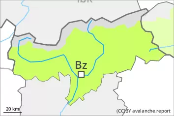
Danger level
 | 2400m |
|  |
|  |

![]()
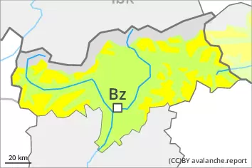
Fresh wind slabs require caution.
During the day: As a consequence of new snow and a sometimes strong southwesterly wind, further wind slabs will form. The fresh wind slabs can be released by a single winter sport participant in particular on steep shady slopes above approximately 2400 m. Avalanche prone locations are to be found in particular in gullies and bowls, and behind abrupt changes in the terrain. The prevalence of the avalanche prone locations will increase with altitude. In some cases avalanches are medium-sized.
In very isolated cases dry avalanches can also be released in the old snowpack. This applies in particular on the Main Alpine Ridge and to the south. Avalanche prone locations are to be found in particular in little used terrain above approximately 2400 m, especially on very steep shady slopes.
On very steep grassy slopes only isolated gliding avalanches are possible below approximately 2400 m.
Evening and first half of night: Increase in danger of dry avalanches as the snowfall becomes more intense, in particular on steep shady slopes at high altitudes and in high Alpine regions.
Snowpack
dp.6: cold, loose snow and wind
dp.2: gliding snow
In some localities up to 10 cm of snow, and even more in some localities, will fall on Thursday above approximately 1500 m, especially in the evening.
The new snow and wind slabs are lying on a crust in all aspects below approximately 2200 m. Especially shady slopes above approximately 2400 m: The new snow and wind slabs are lying on soft layers.
The old snowpack remains subject to considerable local variations at high altitude. Within the snowpack, there are multiple melt-freeze crusts sandwiches with faceted layers in between, in particular on steep sunny slopes in all altitude zones, as well as on shady slopes below approximately 2600 m.
At low and intermediate altitudes only a little snow is lying.
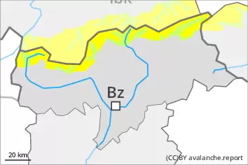
Tendency
Significant increase in avalanche danger as a consequence of new snow and wind. Over a wide area 20 to 40 cm of snow will fall on Friday above approximately 1500 m. Especially from the Passeier Tal to the Southern Zillertal Alps and High Tauern up to 70 cm of snow will fall. More frequent natural dry avalanches are to be expected, even large ones in isolated cases, especially on steep shady slopes at high altitudes and in high Alpine regions in the regions exposed to heavier precipitation.
As a consequence of the snowfall, the likelihood of gliding avalanches being released will increase gradually in particular on steep grassy slopes at intermediate and high altitudes.