The danger of moist avalanches will increase during the day. The fresh and older wind slabs must be evaluated with care and prudence.
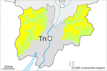
As a consequence of warming moist and wet avalanches are possible as the day progresses, but they can reach medium size in some cases, in particular on steep sunny slopes below approximately 2400 m. Areas with glide cracks are to be avoided. The new snow and wind slabs of the weekend are to be evaluated with care and prudence in all aspects at high altitudes and in high Alpine regions. Avalanches can be triggered in near-surface layers and reach medium size in all aspects. Caution is to be exercised in particular adjacent to ridgelines and in gullies and bowls, as well as in places that are protected from the wind.
Snowpack
dp.10: springtime scenario dp.6: cold, loose snow and wind
Outgoing longwave radiation during the night will be quite good. The solar radiation will give rise as the day progresses to gradual moistening of the snowpack in particular on steep sunny slopes at intermediate altitudes. In all regions below the tree line a little snow is lying.
Tendency
The weather conditions will facilitate a gradual strengthening of the snowpack.
Danger level
treeline
Avalanche Problem
Wind slab
Treeline
Wet snow
2600m
Treeline
The fresh and older wind slabs must be evaluated with care and prudence in all aspects. The danger of moist snow slides and avalanches will increase during the day.
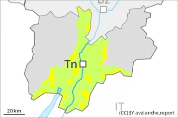
Below approximately 2600 m small and, in isolated cases, medium-sized moist and wet avalanches are possible. As the day progresses as a consequence of warming during the day and solar radiation there will be a gradual increase in the danger of moist and wet avalanches, in particular on steep sunny slopes above the tree line, as well as on steep east, south and west facing slopes. Caution is to be exercised in areas with glide cracks. In the regions with a lot of snow dry slab avalanches are possible. The new snow and wind slabs of the last few days can be released, especially by large additional loads, in all aspects at high altitudes and in high Alpine regions. These can in isolated cases reach quite a large size. The prevalence of the avalanche prone locations will increase with altitude. Caution is to be exercised in particular adjacent to ridgelines and in gullies and bowls, as well as in places that are protected from the wind.
Snowpack
dp.10: springtime scenario
Outgoing longwave radiation during the night will be quite good. The solar radiation will give rise as the day progresses to gradual moistening of the snowpack in particular on steep sunny slopes at intermediate altitudes. As a consequence of the occasionally strong wind, the snow drift accumulations have increased in size during the last few days. The new snow and wind slabs of the last few days are lying on soft layers above approximately 2200 m. The weather conditions gave rise to gradual settling of the snowpack. In all regions below the tree line a little snow is lying.
Tendency
Gradual decrease in danger of dry avalanches as a consequence of warming during the day. More gliding avalanches and wet snow slides are possible on Friday, in particular medium-sized ones.