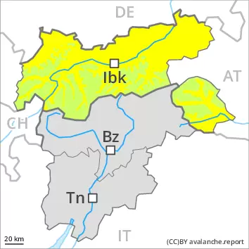
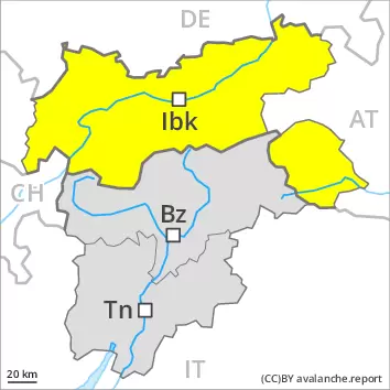
Wind slabs are in some cases still prone to triggering above approximately 2700 m. Wet and gliding snow are to be assessed with care and prudence.
The deep wind slabs can be released by a single winter sport participant in isolated cases in particular on very steep shady slopes above approximately 2700 m. Avalanches can in very isolated cases reach medium size. Avalanches can in very isolated cases be triggered in the old snowpack and reach quite a large size. Avalanche prone locations are to be found in particular on steep shady slopes above approximately 2700 m. As a consequence of warming during the day and solar radiation more medium-sized and, in isolated cases, large avalanches are possible. This applies in particular at the base of rock walls. Caution is to be exercised in areas with glide cracks.
Snowpack
dp.10: springtime scenario
The wind slabs can be released by a single winter sport participant on wind-protected shady slopes above approximately 2700 m. Outgoing longwave radiation during the night will be good over a wide area. The spring-like weather conditions will give rise to thorough wetting of the snowpack below approximately 2700 m. Isolated avalanche prone weak layers exist in the centre of the snowpack in particular on west, north and east facing slopes. At low altitude only a little snow is lying. In some localities 2 to 5 cm of snow has fallen above approximately 2200 m. Until late morning the wind will be moderate to strong at times.
Tendency
Saturday: In the afternoon as a consequence of new snow and strong wind there will be only a slight increase in the avalanche danger.
Danger level
2600m
Avalanche Problem
Wet snow
2600m
Gliding snow
2600m
As a consequence of warming and solar radiation an unfavourable avalanche situation will prevail.
As the day progresses as a consequence of warming during the day and solar radiation there will be a rapid increase in the danger of wet avalanches. As the penetration by moisture increases medium-sized and, in isolated cases, large wet and gliding avalanches are possible. This applies on steep sunny slopes especially below approximately 2600 m, as well as on steep shady slopes below approximately 2200 m.
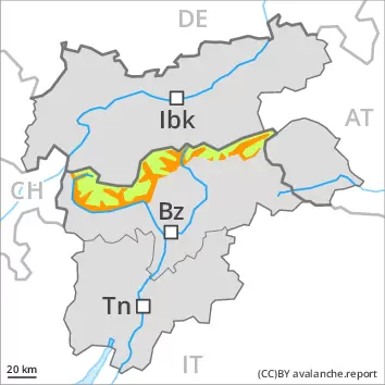
As a consequence of new snow and a strong wind from northerly directions, mostly small wind slabs formed by late in the night in high Alpine regions. The fresh wind slabs can be released by a single winter sport participant in isolated cases in particular on very steep shady slopes.
Snowpack
dp.10: springtime scenario dp.2: gliding snow
Outgoing longwave radiation during the night will be reduced in some case. The surface of the snowpack will freeze very little. Sunshine and high temperatures will give rise as the day progresses to a loss of strength within the snowpack below approximately 2600 m.
The fresh wind slabs have bonded quite well with the old snowpack. They are mostly small and can only be released in isolated cases. The activity of wet and gliding avalanches will rapidly increase.
Tendency
As a consequence of sharply falling temperatures the snowpack will consolidate towards the evening. In some regions 5 to 15 cm of snow will fall from the afternoon. As a consequence of new snow and a sometimes strong northerly wind, mostly small wind slabs will form towards the evening.
AM Danger level
2600m
Avalanche Problem
Gliding snow
2600m
PM Danger level
2600m
Avalanche Problem
Gliding snow
2600m
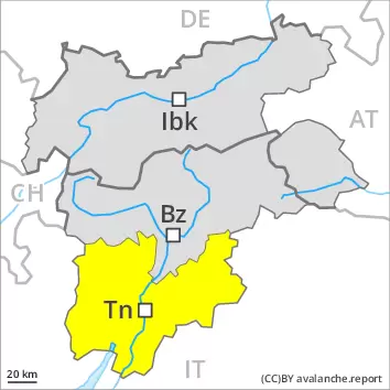
Wet snow
2800m
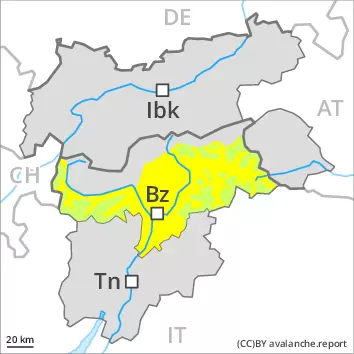
The avalanche danger will increase during the day. Wet and gliding avalanches are possible.
As a consequence of warming during the day and the solar radiation, the likelihood of wet avalanches being released will increase gradually. As the moisture increases numerous loose snow avalanches are to be expected, even medium-sized ones, in the regions exposed to a lot of new snow especially on very steep sunny slopes. On very steep west facing slopes individual medium-sized wet slab avalanches are possible below approximately 2400 m. This applies in particular in the afternoon. On steep grassy slopes more gliding avalanches are possible, even large ones in isolated cases. Areas with glide cracks are to be avoided.
The fresh wind slabs can be released by a single winter sport participant in isolated cases in particular on very steep shady slopes above approximately 2600 m. Mostly avalanches are only small. In regions exposed to heavier precipitation such avalanche prone locations are a little more prevalent. The wind slabs are clearly recognisable to the trained eye.
Snowpack
dp.10: springtime scenario dp.2: gliding snow
Outgoing longwave radiation during the night was quite good over a wide area. The old snowpack will be moist below approximately 2400 m. Sunshine and high temperatures will give rise as the day progresses to increasing and thorough wetting of the snowpack. This applies in particular on steep sunny slopes.
5 to 15 cm of snow, and even more in some localities, has fallen above approximately 2400 m. This applies in particular in the north. The wind was moderate to strong. The fresh wind slabs have bonded quite well with the old snowpack. They are mostly small and can only be released in isolated cases.
Tendency
The surface of the snowpack will freeze to form a strong crust. Decrease in danger of wet avalanches. Over a wide area 5 to 15 cm of snow will fall from midday. The wind will be strong. Mostly small wind slabs will form.
Danger level
2600m
Avalanche Problem
Wet snow
2600m
Gliding snow
2600m
As a consequence of warming and solar radiation an unfavourable avalanche situation will prevail.
As the day progresses as a consequence of warming during the day and solar radiation there will be a rapid increase in the danger of wet avalanches. As the penetration by moisture increases individual medium-sized wet and gliding avalanches are possible. This applies on steep sunny slopes especially below approximately 2600 m, as well as on steep shady slopes below approximately 2200 m.
The danger is within the upper range of danger level 2 (moderate).
Snowpack
dp.10: springtime scenario dp.2: gliding snow
Outgoing longwave radiation during the night will be quite good over a wide area. The surface of the snowpack will freeze to form a strong crust. Sunshine and high temperatures will give rise as the day progresses to a loss of strength within the snowpack below approximately 2600 m.
Tendency
As a consequence of sharply falling temperatures the snowpack will consolidate towards the evening. In some regions 5 to 15 cm of snow will fall from the afternoon. As a consequence of new snow and a sometimes strong northerly wind, mostly small wind slabs will form towards the evening.