The weather will be exceptionally warm. The danger of wet avalanches will already be elevated in the early morning. Little snow will fall in the evening.
In the early morning the natural activity of wet avalanches will rapidly increase. This applies on steep east and west facing slopes below approximately 2800 m, as well as on steep south facing slopes in all altitude zones, this also applies on shady slopes below approximately 2600 m. In some cases the wet avalanches can release the saturated snowpack and reach large size.
On steep grassy slopes individual medium-sized gliding avalanches are possible below approximately 2600 m. Areas with glide cracks are to be avoided. In steep gullies wet avalanches can in some cases reach areas without any snow cover.
Backcountry tours and ascents to alpine cabins should be started very early and concluded timely.
Snowpack
dp.10: springtime scenario dp.6: cold, loose snow and wind
The surface of the snowpack will cool hardly at all during the overcast night and will already be soft in the early morning. Until the evening the weather will be exceptionally warm. The high temperatures will give rise to extreme and thorough wetting of the snowpack especially on very steep slopes. These conditions will cause a rapid weakening of the snowpack. In particular in the north in some localities up to 10 cm of snow will fall in the evening. The wind will be strong to storm force in particular on the Main Alpine Ridge and to the north. The fresh wind slabs are mostly very small.
Tendency
Temporary increase in danger of dry avalanches as a consequence of the new snow. Temporary decrease in danger of wet avalanches as the temperature drops.
EARLIER Danger level
Avalanche Problem
Wet snow
Gliding snow
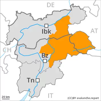
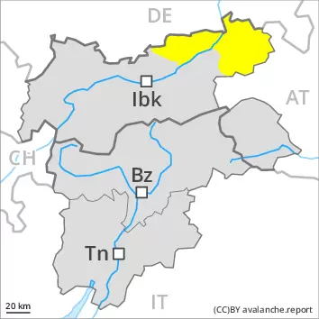
2600m
LATER Danger level
Avalanche Problem
Wet snow
Wind slab
2400m
Gliding snow
2600m
The weather will be exceptionally warm. The danger of wet avalanches will already be elevated in the early morning. Some snow will fall in the evening.
In the early morning the natural activity of wet avalanches will rapidly increase. This applies on steep east and west facing slopes below approximately 2800 m, as well as on steep south facing slopes in all altitude zones, this also applies on shady slopes below approximately 2600 m. In some cases the wet avalanches can release the saturated snowpack and reach large size.
On steep grassy slopes individual medium-sized gliding avalanches are possible below approximately 2600 m. Areas with glide cracks are to be avoided. In steep gullies wet avalanches can in some cases reach areas without any snow cover.
Backcountry tours and ascents to alpine cabins should be started very early and concluded timely.
Snowpack
dp.10: springtime scenario dp.6: cold, loose snow and wind
The surface of the snowpack will cool hardly at all during the overcast night and will already be soft in the early morning. Until the evening the weather will be exceptionally warm. The high temperatures will give rise to extreme and thorough wetting of the snowpack especially on very steep slopes. These conditions will cause a rapid weakening of the snowpack. In some regions 10 to 25 cm of snow will fall in the evening. The wind will be strong to storm force in particular on the Main Alpine Ridge and to the north. As a consequence of new snow and a strong wind, mostly small wind slabs will form towards the evening. The fresh wind slabs are in some cases prone to triggering.
Tendency
Temporary increase in danger of dry avalanches as a consequence of the new snow. Temporary decrease in danger of wet avalanches as the temperature drops.
Danger level
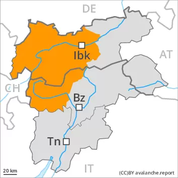
2400m
Avalanche Problem
Wet snow
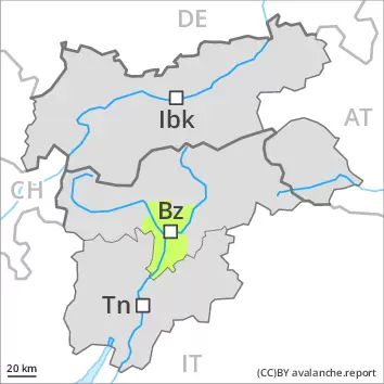
2400m
Gliding snow
2400m
The weather will be exceptionally warm. The danger of wet avalanches will increase during the day. Some snow will fall in the evening.
In the early morning the natural activity of wet avalanches will rapidly increase. This applies on steep east and west facing slopes below approximately 2800 m, as well as on steep south facing slopes in all altitude zones, this also applies on shady slopes below approximately 2600 m. In some cases the wet avalanches can release the saturated snowpack and reach large size.
On steep grassy slopes individual medium-sized gliding avalanches are possible below approximately 2400 m. Areas with glide cracks are to be avoided.
Backcountry tours and ascents to alpine cabins should be started very early and concluded timely.
Snowpack
dp.10: springtime scenario dp.2: gliding snow
The surface of the snowpack will cool hardly at all during the overcast night and will already be soft in the early morning. Until the evening the weather will be exceptionally warm. The high temperatures will give rise to extreme and thorough wetting of the snowpack especially on very steep slopes. These conditions will cause a rapid weakening of the snowpack. In particular in the west in some localities up to 10 cm of snow will fall in the evening. The fresh wind slabs are mostly very small.
Tendency
Temporary increase in danger of dry avalanches as a consequence of the new snow. Temporary decrease in danger of wet avalanches as the temperature drops.
Danger level
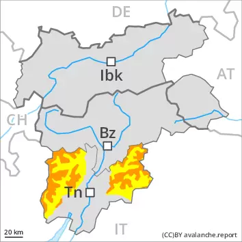
treeline
Avalanche Problem
Wet snow
Treeline
Gliding snow
2000m
Gliding avalanches and moist snow slides are the main danger.
On steep grassy slopes medium-sized gliding avalanches are possible. As a consequence of warming during the day and the solar radiation, the likelihood of gliding avalanches and wet snow slides being released will increase quickly in all aspects, not only on sunny slopes, including on steep shady slopes at intermediate and high altitudes. In isolated cases, wet avalanches can reach intermediate altitudes in steep gullies. Areas with glide cracks are to be avoided.
Snowpack
dp.10: springtime scenario dp.2: gliding snow
The surface of the snowpack will freeze very little and will already be soft in the early morning. The high temperatures will give rise to extreme and thorough wetting of the snowpack especially on very steep slopes. These conditions will cause a rapid weakening of the snowpack. In particular in the west in some localities up to 10 cm of snow will fall in the evening. The fresh wind slabs are mostly very small.
Tendency
Temporary increase in danger of dry avalanches as a consequence of the new snow. Temporary decrease in danger of wet avalanches as the temperature drops.
Danger level
Avalanche Problem
Wet snow
Gliding snow
The danger of wet avalanches will already increase in the early morning.
As a consequence of warming and solar radiation, the natural activity of wet avalanches will increase. This applies in all aspects. In isolated cases the wet avalanches can release the saturated snowpack and reach medium size.
On steep grassy slopes medium-sized gliding avalanches are possible. Areas with glide cracks are to be avoided. In steep gullies wet avalanches can in isolated cases reach areas without any snow cover.
Backcountry tours and ascents to alpine cabins should be started and concluded very early.
Snowpack
dp.10: springtime scenario dp.2: gliding snow
The weather will be exceptionally warm. The wind will be strong to storm force adjacent to ridgelines especially in the regions exposed to the foehn wind. The surface of the snowpack will freeze very little and will already be soft in the early morning. Sunshine and high temperatures gave rise to extreme and thorough wetting of the snowpack especially on very steep slopes. These conditions brought about a rapid weakening of the snowpack. Hardly any snow is lying at low altitude. Evening: Above approximately 1600 m snow will fall.
Tendency
As the temperature drops there will be a gradual decrease in the danger of wet avalanches. Some snow will fall. Temporary increase in danger of dry avalanches as a consequence of the new snow.
Danger level
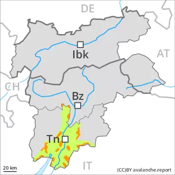
2000m
Avalanche Problem
Wet snow
2000m
The weather will be exceptionally warm. Wet snow requires caution.
As a consequence of warming, the activity of wet avalanches will rapidly increase. This applies in all aspects. In some cases the wet avalanches can release the saturated snowpack. Mostly they are rather small.
On steep grassy slopes mostly small gliding avalanches are possible.
Snowpack
dp.10: springtime scenario
Until the evening the weather will be exceptionally warm. The surface of the snowpack will cool hardly at all during the overcast night and will already be soft in the early morning. These conditions will cause a rapid weakening of the snowpack. Hardly any snow is lying at low and intermediate altitudes.
Tendency
Temporary decrease in danger of wet avalanches as the temperature drops. Some snow will fall in some regions.