The danger of wet avalanches will increase quickly in the early morning. More small to medium-sized wet avalanches are possible. This applies in all aspects below approximately 2800 m, as well as on extremely steep sunny slopes at elevated altitudes. In very isolated cases avalanches can release the saturated snowpack and reach a dangerous size.
In addition still more very occasional gliding avalanches are possible. This applies on steep grassy slopes below approximately 2600 m. Areas with glide cracks are to be avoided.
Apart from the danger of being buried, restraint should be exercised in particular in view of the danger of avalanches sweeping people along and giving rise to falls.
Snowpack
dp.10: springtime scenario
The surface of the snowpack will cool hardly at all during the temporarily overcast night. The high temperatures from the early morning will give rise to increasing and thorough wetting of the snowpack in all aspects below approximately 2800 m, this also applies on sunny slopes at elevated altitudes.
At low and intermediate altitudes from a snow sport perspective, in most cases insufficient snow is lying.
Tendency
Temporary decrease in danger of wet avalanches as the temperature drops.
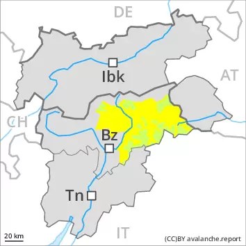
Danger level
1800m
Avalanche Problem
Wet snow
1800m
Increase in danger of moist and wet avalanches in the course of the day.
As a consequence of the precipitation, the likelihood of moist and wet avalanches being released will increase gradually especially on extremely steep sunny slopes. Mostly these are small. This also applies in isolated cases on shady slopes below approximately 2800 m.
In addition further gliding avalanches are possible, in particular on steep grassy slopes below approximately 2600 m. Areas with glide cracks are to be avoided.
Snowpack
dp.10: springtime scenario
The surface of the snowpack will freeze to form a strong crust only at high altitudes. The weather conditions as the day progresses will give rise to increasing softening of the snowpack also on shady slopes at elevated altitudes.
Tendency
Some snow will fall in some regions. This applies above approximately 2000 m. The danger of dry and wet avalanches will increase during the day.
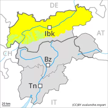
Danger level
2800m
Avalanche Problem
Wet snow
2800m
Wet snow requires caution.
Small to medium-sized wet loose snow avalanches are possible below approximately 2800 m, this also applies on extremely steep sunny slopes in high Alpine regions. As a consequence of warming during the day and the solar radiation, the likelihood of wet avalanches being released will increase a little. In very isolated cases avalanches can release the saturated snowpack and reach a dangerous size. This applies in the regions with a lot of snow.
In addition further individual gliding avalanches are possible. This applies on steep grassy slopes below approximately 2600 m. Areas with glide cracks are to be avoided.
Snowpack
dp.10: springtime scenario
The surface of the snowpack will cool hardly at all during the temporarily overcast night and will soften quickly. The high temperatures as the day progresses will give rise to increasing softening of the snowpack in all aspects below approximately 2800 m, this also applies on sunny slopes in high Alpine regions.
Below approximately 2000 m only a little snow is now lying.
Tendency
Wet snow represents the main danger.
This is the final avalanche report for the winter 2023/24. Current information and announcements are posted on our blog.
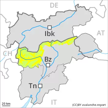
Danger level
2800m
Avalanche Problem
Wet snow
2800m
Wet snow requires caution.
The danger of wet avalanches will increase quickly in the early morning. More small to medium-sized wet avalanches are possible. This applies in all aspects below approximately 2800 m, as well as on extremely steep sunny slopes in high Alpine regions. In very isolated cases avalanches can release the saturated snowpack and reach a dangerous size.
In addition still more very occasional gliding avalanches are possible. This applies on steep grassy slopes below approximately 2600 m. Areas with glide cracks are to be avoided.
High Alpine regions: The fresh and older wind slabs are in isolated cases prone to triggering. Very isolated avalanche prone locations are to be found in particular on very steep shady slopes in high Alpine regions. Apart from the danger of being buried, restraint should be exercised in particular in view of the danger of avalanches sweeping people along and giving rise to falls.
Snowpack
dp.10: springtime scenario
The surface of the snowpack will cool hardly at all during the temporarily overcast night and will soften quickly. The high temperatures from the early morning will give rise to increasing and thorough wetting of the snowpack in all aspects below approximately 2800 m, this also applies on sunny slopes in high Alpine regions.
High Alpine regions: In some localities up to 15 cm of snow will fall. As a consequence of a sometimes strong wind from southerly directions, mostly small wind slabs will form in particular in the vicinity of peaks. The no longer entirely fresh wind slabs of the last few days are now only very rarely prone to triggering.
Tendency
Temporary decrease in danger of wet avalanches as the temperature drops.
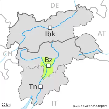
Danger level
2800m
Avalanche Problem
Wet snow
2800m
Wet snow represents the main danger.
The danger of wet snow slides and avalanches will already increase in the late morning. As the day progresses more frequent small to medium-sized wet loose snow avalanches are possible below approximately 2800 m. This applies on extremely steep slopes in all aspects. On very steep shady slopes individual wet slab avalanches are possible between approximately 2400 and 2800 m. In isolated cases avalanches can release the saturated snowpack and reach a dangerous size.
In addition individual small to medium-sized gliding avalanches are possible. This applies on steep grassy slopes below approximately 2600 m. Areas with glide cracks are to be avoided.
Snowpack
dp.10: springtime scenario dp.2: gliding snow
Outgoing longwave radiation during the night will be severely restricted. The surface of the snowpack will freeze very little and will already be soft in the early morning. As a consequence of mild temperatures and high relative humidity the snowpack can not consolidate. Some rain will fall in some regions. The weather conditions will give rise to increasing and thorough wetting of the snowpack.
Below approximately 2000 m from a snow sport perspective, in most cases insufficient snow is lying.
Tendency
Slight decrease in danger of wet avalanches as the temperature drops. Some snow will fall in some localities. This applies above approximately 2200 m.
This is the final avalanche report for the winter 2023/24. Current information and announcements are posted on our blog.
Danger level
Wet snow requires caution.
The danger of wet avalanches will already increase in the late morning. Especially on extremely steep slopes individual mostly small wet avalanches are possible.
Snowpack
dp.10: springtime scenario
The surface of the snowpack will cool hardly at all during the temporarily overcast night and will soften quickly. The high temperatures as the day progresses will give rise to rapid and thorough wetting of the snowpack also on shady slopes at elevated altitudes.
At low and intermediate altitudes from a snow sport perspective, insufficient snow is lying.
Tendency
Temporary decrease in danger of wet avalanches as the temperature drops.
Danger level
1800m
Avalanche Problem
Wet snow
1800m
Increase in danger of wet avalanches in the course of the day.
As a consequence of the rain, the likelihood of moist and wet avalanches being released will increase gradually. This applies in all aspects. Mostly the avalanches are small.
Snowpack
dp.10: springtime scenario dp.3: rain
The surface of the snowpack is not frozen and will already be soft in the early morning.
Below approximately 1800 m no snow is lying.
Tendency
Above approximately 2000 m snow will fall. The danger of moist and wet snow slides will increase but remain within the current danger level.