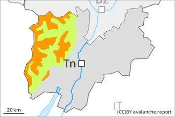
New snow and wind slabs above approximately 1800 m. In addition the wind slabs in gullies and bowls, and behind abrupt changes in the terrain are capable of being triggered. Weak layers exist in the old snowpack in particular on steep shady slopes.
As a consequence of new snow and a moderate to strong wind, sometimes easily released wind slabs formed in particular adjacent to ridgelines and in gullies and bowls. The danger will increase during the day, reaching danger level 4 (high). On steep shady slopes and in gullies and bowls, and behind abrupt changes in the terrain slab avalanches are possible, even large ones.
Snowpack
dp.6: cold, loose snow and wind dp.1: deep persistent weak layer
Over a wide area over a wide area 40 to 80 cm of snow, and even more in some localities, will fall until Tuesday above approximately 1800 m. The snowpack will become in most cases subject to considerable local variations. The various wind slabs have bonded poorly with the old snowpack. The rain gave rise to thorough wetting of the snowpack over a wide area below approximately 1700 m.
Tendency
Wednesday: The avalanche danger will persist.
Danger level
treeline
Avalanche Problem
New snow
Treeline
Wind slab
Treeline
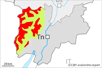
New snow and wind slabs above approximately 1800 m. In addition the wind slabs in gullies and bowls, and behind abrupt changes in the terrain are capable of being triggered. Weak layers exist in the old snowpack in particular on steep shady slopes.
As a consequence of new snow and a moderate to strong wind, sometimes easily released wind slabs formed in particular adjacent to ridgelines and in gullies and bowls. On steep shady slopes and in gullies and bowls, and behind abrupt changes in the terrain slab avalanches are possible, even large ones.
Snowpack
dp.6: cold, loose snow and wind dp.1: deep persistent weak layer
Over a wide area over a wide area 30 to 60 cm of snow, and even more in some localities, will fall until Tuesday above approximately 1800 m. The snowpack will become in most cases subject to considerable local variations. The various wind slabs have bonded poorly with the old snowpack. The rain gave rise to thorough wetting of the snowpack over a wide area below approximately 1700 m.
Tendency
Wednesday: The avalanche danger will persist.
Danger level
treeline
Avalanche Problem
Wind slab
Treeline
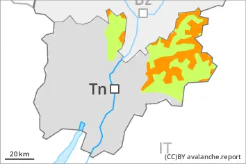
New snow
2000m
The new snow and wind slabs represent the main danger. Already in the early morning, a few wet avalanches are possible.
⚠ Error: Incomplete joker sentence
Snowpack
The snowpack will be subject to considerable local variations. The various wind slabs have bonded poorly with each other and the old snowpack. The rain gave rise to thorough wetting of the snowpack below approximately 2000 m.