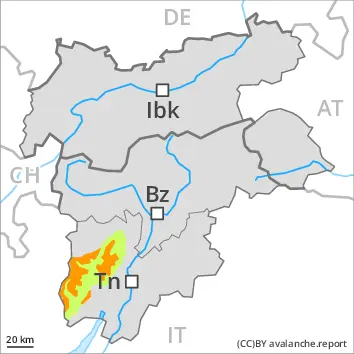
New snow and wind slabs represent the main danger. Individual mostly small moist and wet avalanches are possible.
Over a wide area 10 to 20 cm of snow has fallen above approximately 1700 m. Up to 10 cm of snow, and even more in some localities, will fall until Thursday above approximately 1700 m. The avalanche danger will increase but remain within the current danger level. The wind slabs must be evaluated with care and prudence in all aspects above the tree line. The avalanche prone locations are to be found in particular adjacent to ridgelines and in gullies and bowls, and behind abrupt changes in the terrain. As a consequence of warming during the day individual small to medium-sized moist and wet avalanches are possible.
Snowpack
dp.6: cold, loose snow and wind dp.10: springtime scenario
Over a wide area up to 20 cm of snow will fall above approximately 1800 m. The wind will transport the new snow. The more recent wind slabs are bonding poorly with the old snowpack in all aspects at intermediate and high altitudes. Below approximately 1800 m only a small amount of snow is lying for the time of year.
Tendency
The avalanche danger will persist.
Danger level
2000m
Avalanche Problem
Wind slab
2000m
Fresh wind slabs are to be evaluated critically.
The avalanche danger is within the upper range of danger level 2 (moderate). As a consequence of a sometimes strong wind from southerly directions, avalanche prone wind slabs will form. Caution is to be exercised in particular on very steep shady slopes adjacent to ridgelines and in gullies and bowls at high altitudes and in high Alpine regions. Small and, in isolated cases, medium-sized natural avalanches are possible.
Dry loose snow avalanches are possible. In the event of prolonged bright spells this applies on extremely steep slopes, especially in the regions exposed to heavier precipitation. Mostly the avalanches are small and can be released by a single winter sport participant.
Weak layers in the old snowpack can be released in very isolated cases. The avalanche prone locations are to be found in particular on extremely steep shady slopes above approximately 2400 m. Avalanches can reach quite a large size.
Snowpack
dp.6: cold, loose snow and wind dp.10: springtime scenario
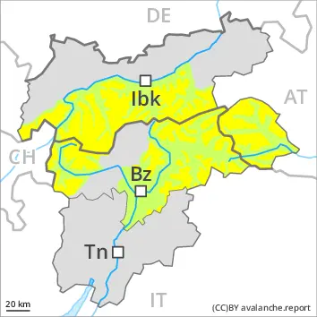
Up to 20 cm of snow, and even more in some localities, has fallen. Up to 20 cm of snow, and even more in some localities, will fall. This applies at high altitudes and in high Alpine regions. The wind will transport the new snow and, in some cases, old snow as well. The fresh wind slabs are lying on soft layers on shady slopes at elevated altitudes. Faceted weak layers exist in the bottom section of the snowpack on west, north and east facing slopes. Only a small amount of snow is lying for the time of year.
Tendency
Fresh wind slabs represent the main danger. In some localities up to 20 cm of snow will fall.
Danger level
2000m
Avalanche Problem
Wind slab
2000m
Fresh wind slabs at high altitude.
As a consequence of a moderate to strong wind from southwesterly directions, avalanche prone wind slabs will form. Caution is to be exercised in particular on very steep shady slopes adjacent to ridgelines and in gullies and bowls at high altitudes and in high Alpine regions.
Individual dry loose snow avalanches are possible. In the event of prolonged bright spells this applies on extremely steep slopes, especially in the regions exposed to heavier precipitation. Mostly the avalanches are small. On steep grassy slopes individual small and, in isolated cases, medium-sized gliding avalanches are possible. Weak layers in the old snowpack can be released in very isolated cases. The avalanche prone locations are to be found in particular on extremely steep shady slopes above approximately 2400 m. Avalanches can reach medium size in isolated cases.
Snowpack
dp.6: cold, loose snow and wind
10 to 20 cm of snow, and even more in some localities, will fall. This applies at high altitudes and in high Alpine regions. The wind will transport the new snow and, in some cases, old snow as well. The fresh wind slabs are lying on soft layers on shady slopes at elevated altitudes. Faceted weak layers exist in the bottom section of the snowpack on west, north and east facing slopes. Only a small amount of snow is lying for the time of year.
Tendency
Fresh wind slabs represent the main danger. In some localities up to 20 cm of snow will fall.
Danger level
treeline
Avalanche Problem
Wind slab
Treeline
Wet snow
Treeline
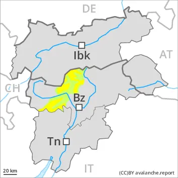
New snow and wind slabs represent the main danger. More small to medium-sized moist and wet avalanches are possible.
Over a wide area 5 to 15 cm of snow has fallen above approximately 1700 m. Over a wide area up to 15 cm of snow, and even more in some localities, will fall until Thursday above approximately 1700 m. The avalanche danger will increase but remain within the current danger level. The wind slabs must be evaluated with care and prudence in all aspects above the tree line. The avalanche prone locations are to be found in particular adjacent to ridgelines and in gullies and bowls, and behind abrupt changes in the terrain. As a consequence of warming during the day individual small to medium-sized moist and wet avalanches are possible.
Snowpack
dp.6: cold, loose snow and wind dp.10: springtime scenario
Over a wide area over a wide area 10 to 20 cm of snow will fall above approximately 1800 m. The wind will transport the new snow. The more recent wind slabs are bonding poorly with the old snowpack in all aspects at intermediate and high altitudes. Below approximately 1800 m only a small amount of snow is lying for the time of year.
Tendency
Danger level
Small loose snow avalanches are possible.
Individual dry loose snow avalanches are possible. In the event of prolonged bright spells this applies on extremely steep slopes, especially in the regions exposed to heavier precipitation. Mostly the avalanches are small. As a consequence of a moderate to strong wind from southwesterly directions, wind slabs will form. These are small and can only be released in isolated cases, especially on very steep shady slopes adjacent to ridgelines at high altitude.
Snowpack
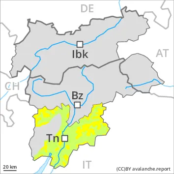
5 to 15 cm of snow, and even more in some localities, will fall. The new snow is lying on soft layers on shady slopes at high altitude. The snowpack will be in most cases stable. The old snowpack will be moist at low and intermediate altitudes. Only a small amount of snow is lying for the time of year.
Tendency
Fresh wind slabs represent the main danger.
Danger level
Small loose snow avalanches are possible.
Individual dry loose snow avalanches are possible. In the event of prolonged bright spells this applies on extremely steep slopes, especially in the regions exposed to heavier precipitation. Mostly the avalanches are small. As a consequence of a moderate to strong wind from southwesterly directions, wind slabs will form. These are small and can only be released in isolated cases, especially on very steep shady slopes adjacent to ridgelines at high altitude. On steep grassy slopes individual small and, in isolated cases, medium-sized gliding avalanches are possible. This applies in particular below approximately 2400 m.
Snowpack
5 to 15 cm of snow, and even more in some localities, will fall. The new snow is lying on soft layers on shady slopes at high altitude. The snowpack will be in most cases stable. The old snowpack will be moist at low and intermediate altitudes. Only a small amount of snow is lying for the time of year.