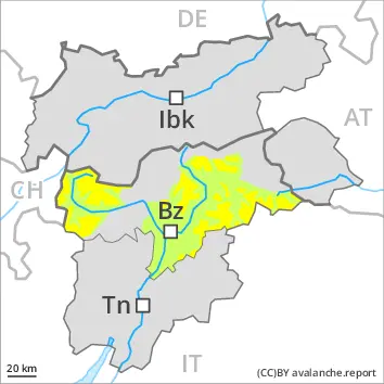
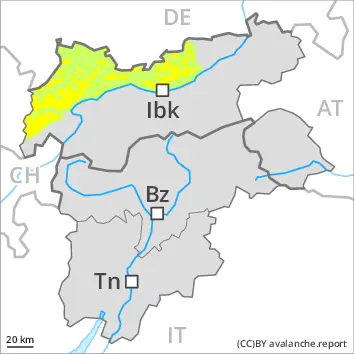
As a consequence of a moderate to strong wind from southwesterly directions, avalanche prone wind slabs will form. Caution is to be exercised in particular on very steep shady slopes adjacent to ridgelines and in gullies and bowls at high altitudes and in high Alpine regions. Mostly the avalanches are medium-sized, especially in the regions exposed to heavier precipitation. Individual medium-sized natural avalanches are possible.
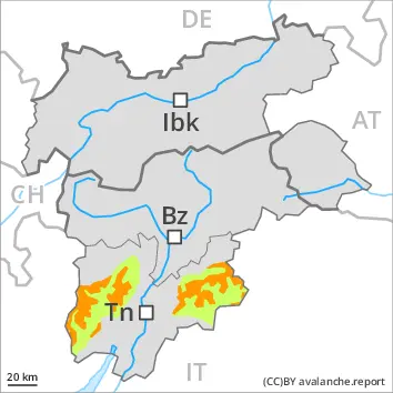
Individual dry loose snow avalanches are possible. In the event of prolonged bright spells this applies on extremely steep slopes, especially in the regions exposed to heavier precipitation. Mostly the avalanches are small.
On steep grassy slopes individual small and, in isolated cases, medium-sized gliding avalanches are possible.
Weak layers in the old snowpack can be released in very isolated cases. The avalanche prone locations are to be found in particular on extremely steep shady slopes above approximately 2400 m. Avalanches can reach medium size in isolated cases.
Snowpack
dp.6: cold, loose snow and wind
10 to 40 cm of snow, and even more in some localities, has fallen since Wednesday. 10 to 20 cm of snow, and even more in some localities, will fall on Friday. This applies at high altitudes and in high Alpine regions. The wind will transport the new snow. The fresh wind slabs are lying on soft layers on shady slopes at elevated altitudes. Faceted weak layers exist in the bottom section of the snowpack on west, north and east facing slopes. The old snowpack will be moist at low and intermediate altitudes. Only a small amount of snow is lying for the time of year.
Tendency
Fresh wind slabs represent the main danger. Up to 10 cm of snow, and even more in some localities, will fall.
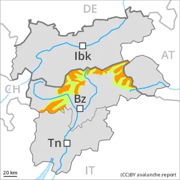
Danger level
2000m
Avalanche Problem
Persistent weak layer
2000m
Wind slab
2000m
Wind slabs and weakly bonded old snow require caution.
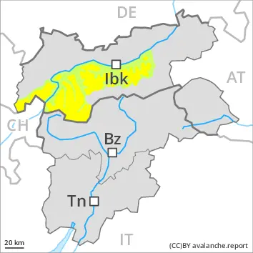
Weak layers in the old snowpack can be released by winter sport participants on very steep west, north and northeast facing slopes. The avalanche prone locations are to be found in particular on little used shady slopes above approximately 2000 m and on very steep west facing slopes above approximately 2300 m. Mostly the avalanches are medium-sized. Individual medium-sized natural avalanches are possible. Caution is to be exercised in particular in the regions exposed to heavier precipitation.
As a consequence of a moderate to strong wind from southwesterly directions, avalanche prone wind slabs formed in the last few days. The number and size of avalanche prone locations will increase with altitude.
Individual dry loose snow avalanches are possible. In the event of prolonged bright spells this applies on extremely steep slopes.
On steep grassy slopes individual small and, in isolated cases, medium-sized gliding avalanches are possible.
Snowpack
dp.1: deep persistent weak layer dp.6: cold, loose snow and wind
10 to 30 cm of snow, and even more in some localities, has fallen since Wednesday. 10 to 20 cm of snow, and even more in some localities, will fall on Friday. This applies at high altitudes and in high Alpine regions. The wind will transport the new snow. Weak layers exist in the centre of the old snowpack in particular on little used shady slopes. Faceted weak layers exist in the bottom section of the snowpack on west, north and east facing slopes. The various wind slabs are lying on soft layers at elevated altitudes. The old snowpack will be moist at low and intermediate altitudes. Only a small amount of snow is lying for the time of year.
Tendency
Wind slabs and weakly bonded old snow require caution. Up to 10 cm of snow, and even more in some localities, will fall.
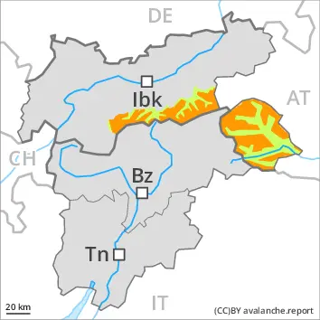
Danger level
treeline
Avalanche Problem
Wind slab
Treeline
Wet snow
2400m
Treeline
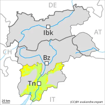
New snow and wind slabs represent the main danger. Small and medium-sized moist and wet avalanches are possible.
As a consequence of new snow and a strong wind from southwesterly directions, sometimes avalanche prone wind slabs will form. The wind slabs must be evaluated with care and prudence in all aspects above the tree line. The avalanche prone locations are to be found in particular adjacent to ridgelines and in gullies and bowls, and behind abrupt changes in the terrain. Individual slab avalanches are possible, even medium-sized ones, especially in the regions exposed to heavier precipitation. As a consequence of warming during the day small and medium-sized moist and wet avalanches are possible.
Snowpack
dp.6: cold, loose snow and wind dp.10: springtime scenario
In particular in the Southern Lagorai, in the Northern Lagorai and in the Primiero- Pale di S. Martino 20 to 30 cm of snow will fall on Friday above approximately 1700 m. Over a wide area 10 to 20 cm of snow has fallen above approximately 1700 m. The wind will transport the new snow. Up to 20 cm of snow, and up to 30 cm in some localities, will fall until Friday above approximately 1600 m. Small and medium-sized moist and wet avalanches are possible. The wind will transport the new snow. Below approximately 1800 m only a small amount of snow is lying for the time of year.
Tendency
The avalanche danger will already increase in the late morning.
Danger level
2000m
Avalanche Problem
Wind slab
2000m
Fresh wind slabs at high altitude.
In the regions neighbouring those that are subject to danger level 3 (considerable) the avalanche danger is higher. As a consequence of a moderate to strong wind from southwesterly directions, avalanche prone wind slabs will form. Caution is to be exercised in particular on very steep shady slopes adjacent to ridgelines and in gullies and bowls at high altitudes and in high Alpine regions. Avalanches can reach medium size in isolated cases, especially in the regions exposed to heavier precipitation. On shady slopes individual natural avalanches are possible.
Individual dry loose snow avalanches are possible. In the event of prolonged bright spells this applies on extremely steep slopes, especially in the regions exposed to heavier precipitation. Mostly the avalanches are small.
On steep grassy slopes individual small and, in isolated cases, medium-sized gliding avalanches are possible.
Weak layers in the old snowpack can be released in very isolated cases. The avalanche prone locations are to be found in particular on extremely steep shady slopes above approximately 2400 m. Avalanches can reach medium size in isolated cases.
Snowpack
dp.6: cold, loose snow and wind
10 to 20 cm of snow, and even more in some localities, has fallen since Wednesday. 10 to 20 cm of snow, and even more in some localities, will fall on Friday. This applies at high altitudes and in high Alpine regions. The wind will transport the new snow. The fresh wind slabs are lying on soft layers on shady slopes at elevated altitudes. Faceted weak layers exist in the bottom section of the snowpack on west, north and east facing slopes. The old snowpack will be moist at low and intermediate altitudes. Only a small amount of snow is lying for the time of year.
Tendency
Fresh wind slabs represent the main danger. Some snow will fall.
Danger level
2000m
Avalanche Problem
Wind slab
2000m
Fresh wind slabs at high altitude.
As a consequence of a moderate to strong wind from southwesterly directions, avalanche prone wind slabs will form. Caution is to be exercised in particular on very steep shady slopes adjacent to ridgelines and in gullies and bowls at high altitudes and in high Alpine regions. Avalanches can reach medium size in isolated cases, especially in the regions exposed to heavier precipitation.
Individual dry loose snow avalanches are possible. In the event of prolonged bright spells this applies on extremely steep slopes, especially in the regions exposed to heavier precipitation. Mostly the avalanches are small. On steep grassy slopes individual small and, in isolated cases, medium-sized gliding avalanches are possible. Weak layers in the old snowpack can be released in very isolated cases. The avalanche prone locations are to be found in particular on extremely steep shady slopes above approximately 2400 m. Avalanches can reach medium size in isolated cases.
Snowpack
dp.6: cold, loose snow and wind
5 to 15 cm of snow has fallen since Wednesday. 5 to 15 cm of snow will fall on Friday. This applies at high altitudes and in high Alpine regions. The wind will transport the new snow. The fresh wind slabs are lying on soft layers in particular on shady slopes at elevated altitudes. Faceted weak layers exist in the bottom section of the snowpack on west, north and east facing slopes. Only a small amount of snow is lying for the time of year.
Tendency
Fresh wind slabs represent the main danger.
Danger level
treeline
Avalanche Problem
Wind slab
Treeline
Wet snow
2400m
Treeline
New snow and wind slabs represent the main danger. Small to medium-sized moist and wet avalanches are possible.
Increase in avalanche danger as a consequence of new snow and strong wind. The avalanche danger will increase but remain within the current danger level. The wind slabs must be evaluated with care and prudence in all aspects above the tree line. The avalanche prone locations are to be found in particular adjacent to ridgelines and in gullies and bowls, and behind abrupt changes in the terrain. Individual slab avalanches are possible, but they will be mostly small, especially in the regions exposed to heavier precipitation especially at elevated altitudes. As a consequence of warming during the day individual small to medium-sized moist and wet avalanches are possible.
Snowpack
dp.6: cold, loose snow and wind dp.10: springtime scenario
Over a wide area 5 to 15 cm of snow has fallen above approximately 1700 m. Over a wide area up to 15 cm of snow, and even more in some localities, will fall on Friday above approximately 1600 m. The wind will transport the new snow. Below approximately 1800 m only a small amount of snow is lying for the time of year.
Tendency
The avalanche danger will already increase in the late morning.
Danger level
2000m
Avalanche Problem
Wind slab
2000m
Fresh wind slabs require caution. Small loose snow avalanches are possible.
As a consequence of a moderate to strong wind from southwesterly directions, sometimes avalanche prone wind slabs formed in the last few days. The number and size of avalanche prone locations will increase with altitude, caution is to be exercised in particular on very steep shady slopes adjacent to ridgelines at high altitude.
Individual dry loose snow avalanches are possible. In the event of prolonged bright spells this applies on extremely steep slopes, especially in the regions exposed to heavier precipitation. Mostly the avalanches are small. On steep grassy slopes individual small and, in isolated cases, medium-sized gliding avalanches are possible. This applies in particular below approximately 2400 m.
Snowpack
dp.6: cold, loose snow and wind
10 to 20 cm of snow, and even more in some localities, has fallen since Wednesday. 5 to 15 cm of snow, and even more in some localities, will fall on Friday. The new snow is lying on soft layers on shady slopes at high altitude. The old snowpack will be moist at low and intermediate altitudes. Only a small amount of snow is lying for the time of year.
Tendency
Fresh wind slabs represent the main danger.
Danger level
Small loose snow avalanches are possible.
Individual dry loose snow avalanches are possible. In the event of prolonged bright spells this applies on extremely steep slopes, especially in the regions exposed to heavier precipitation. Mostly the avalanches are small. As a consequence of a moderate to strong wind from southwesterly directions, wind slabs will form. These are small and can only be released in isolated cases, especially on very steep shady slopes adjacent to ridgelines at high altitude.
Snowpack
5 to 15 cm of snow has fallen since Wednesday. 5 to 10 cm of snow will fall on Friday. The new snow is lying on soft layers on shady slopes at high altitude. The snowpack will be in most cases stable. The old snowpack will be moist at low and intermediate altitudes. Only a small amount of snow is lying for the time of year.