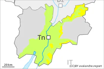
Danger level
 | 2000m |
|  |
|  | ||||
| |
|  |


![]()
New snow and wind slabs represent the main danger.
Over a wide area 10 to 20 cm of snow, and even more in some localities, has fallen above approximately 1800 m. 15 to 25 cm of snow, and even more in some localities, will fall on Saturday above approximately 2000 m. Gradual increase in avalanche danger as a consequence of new snow and wind. Avalanches can occur easily or triggered naturally. This applies even in case of a small load. The avalanche prone locations are to be found in all aspects above approximately 2000 m and in gullies and bowls, and behind abrupt changes in the terrain. In the regions exposed to heavier precipitation caution is to be exercised in particular at the base of rock walls. Wind-loaded slopes where weaknesses exist in the old snowpack are unfavourable. At transitions from a shallow to a deep snowpack, when entering gullies and bowls for example the avalanche prone locations are more prevalent. In the regions exposed to heavier precipitation the avalanche situation is dangerous. Medium-sized avalanches are possible. Careful route selection and spacing between individuals are recommended.
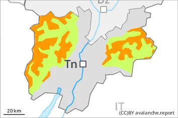
Snowpack
dp.6: cold, loose snow and wind
The new snow and wind slabs are bonding poorly with the old snowpack on steep shady slopes above approximately 2000 m. The fresh wind slabs will be covered with new snow and therefore difficult to recognise.
The old snowpack will be moist at low and intermediate altitudes. Only a small amount of snow is lying for the time of year.
Tendency
The prevalence of avalanche prone locations and likelihood of triggering will increase with altitude.