Danger level
 | treeline |
|  |
|  | ||||
|  |
| |


![]()
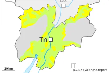
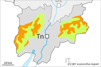
New snow and wind slabs represent the main danger.
Small and medium-sized moist and wet avalanches are possible.
As a consequence of new snow and a strong wind from southwesterly directions, sometimes avalanche prone wind slabs will form.
The wind slabs must be evaluated with care and prudence in all aspects above the tree line. The avalanche prone locations are to be found in particular adjacent to ridgelines and in gullies and bowls, and behind abrupt changes in the terrain.
Individual slab avalanches are possible, even medium-sized ones, especially in the regions exposed to heavier precipitation.
As a consequence of warming during the day small and medium-sized moist and wet avalanches are possible.
Snowpack
dp.6: cold, loose snow and wind
dp.10: springtime scenario
In particular in the Southern Lagorai, in the Northern Lagorai and in the Primiero- Pale di S. Martino 20 to 30 cm of snow will fall on Friday above approximately 1700 m. Over a wide area 10 to 20 cm of snow has fallen above approximately 1700 m.
The wind will transport the new snow.
Up to 20 cm of snow, and up to 30 cm in some localities, will fall until Friday above approximately 1600 m.
Small and medium-sized moist and wet avalanches are possible.
The wind will transport the new snow.
Below approximately 1800 m only a small amount of snow is lying for the time of year.
Tendency
The avalanche danger will already increase in the late morning.