Wind slabs and wet snow represent the main danger. Weak layers in the old snowpack are treacherous.
Weak layers in the old snowpack can still be released in some places by individual winter sport participants. From early morning the likelihood of natural moist avalanches being released will increase gradually below approximately 2600 m. The avalanche prone locations are to be found especially at the base of rock walls and behind abrupt changes in the terrain, and in gullies and bowls. A few gliding avalanches and moist snow slides are possible. The current avalanche situation calls for careful route selection.
Snowpack
dp.1: deep persistent weak layer dp.10: springtime scenario
The wind slabs of recent weeks remain in some cases prone to triggering in particular on steep shady slopes. Precarious weak layers exist deep in the old snowpack on little used shady slopes. In addition the danger of moist and wet avalanches will increase as the day progresses.
Tendency
Saturday: Some snow will fall over a wide area. The avalanche danger will persist.
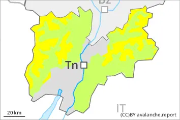
EARLIER Danger level
Avalanche Problem
Wet snow
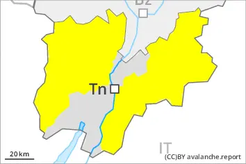
LATER Danger level
1700m
Avalanche Problem
Wet snow
1700m
Moist and wet avalanches require caution. Weak layers in the old snowpack are treacherous.
From early morning the likelihood of moist and wet avalanches being released will increase gradually in all altitude zones. Weak layers in the old snowpack can still be released in some places by individual winter sport participants. The avalanche prone locations are to be found in particular on steep, little used slopes above approximately 1700 m. The current avalanche situation calls for careful route selection.
Snowpack
dp.10: springtime scenario
As a consequence of warming during the day and solar radiation there will be an increase in the danger of moist and wet avalanches to level 2 (moderate). Precarious weak layers exist deep in the old snowpack on little used shady slopes.
Tendency
Saturday: Some snow will fall over a wide area. The avalanche danger will persist.