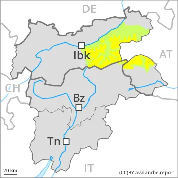
Increase in avalanche danger as a consequence of new snow and wind. Weakly bonded old snow requires caution.
As a consequence of new snow and a sometimes strong wind from northerly directions, avalanche prone wind slabs will form in the course of the day. These can be released by a single winter sport participant. This applies in particular on near-ridge shady slopes above approximately 2400 m.
Weak layers in the upper part of the snowpack can be released by individual winter sport participants. The avalanche prone locations are to be found in particular on steep, little used west, north and east facing slopes above approximately 2200 m. Mostly avalanches are medium-sized.
Snowpack
dp.6: cold, loose snow and wind
20 to 30 cm of snow, and even more in some localities, will fall. The new snow will be deposited on soft layers on shady slopes above approximately 2400 m. Avalanche prone weak layers exist in the old snowpack especially on little used west, north and east facing slopes. This applies in particular above approximately 2200 m.
West, south and east facing slopes below approximately 2400 m: The new snow will be deposited on a crust.
The snowpack will be subject to considerable local variations at intermediate altitudes. Below the tree line only a little snow is now lying.
Tendency
Hardly any change in avalanche danger.
Danger level
2400m
Avalanche Problem
Wind slab
2400m
Persistent weak layer
2400m
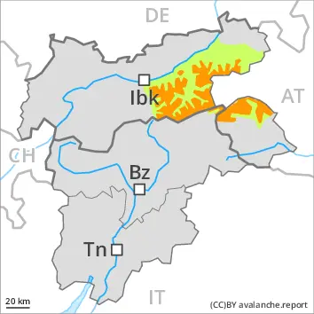
Wind slabs and weakly bonded old snow require caution.
Fresh wind slabs are to be evaluated with care and prudence in particular on very steep shady slopes above approximately 2400 m, especially adjacent to ridgelines. Restraint should be exercised because avalanches can sweep people along and give rise to falls.
Weak layers in the old snowpack can still be released in isolated cases by individual winter sport participants. The avalanche prone locations are to be found in particular on steep, little used west, north and east facing slopes above approximately 2400 m. Mostly avalanches are medium-sized. In isolated cases avalanches can also release deeper layers of the snowpack and reach large size.
The danger of wet loose snow avalanches will already exist in the early morning. This applies in particular on steep west facing slopes.
Snowpack
dp.6: cold, loose snow and wind dp.5: snowfall after a long period of cold
Some snow will fall in some regions, in particular on the Main Alpine Ridge and in the High Tauern. Up to 10 cm of snow, and even more in some localities, will fall. As a consequence of a storm force wind from northeasterly directions, mostly small wind slabs will form especially adjacent to ridgelines. These will be deposited on soft layers in particular on steep shady slopes above approximately 2400 m.
Avalanche prone weak layers exist in the old snowpack especially on little used west, north and east facing slopes.
The surface of the snowpack will cool hardly at all during the overcast night and will soften quickly. Below the tree line only a little snow is now lying.
Tendency
Hardly any change in avalanche danger.
EARLIER Danger level
2200m
Avalanche Problem
Persistent weak layer
2200m
LATER Danger level
2200m
Avalanche Problem
Persistent weak layer
2200m
Wind slab
2400m
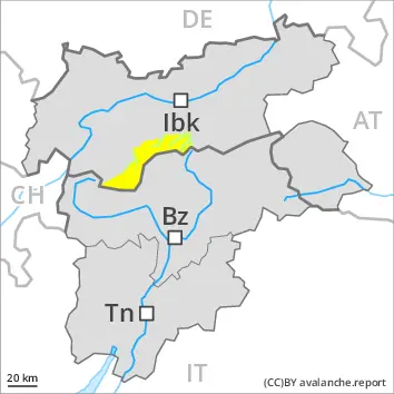
Slight increase in avalanche danger as a consequence of new snow and wind. Weakly bonded old snow requires caution.
As a consequence of new snow and a sometimes strong wind from northerly directions, rather small wind slabs will form in the course of the day. These can be released by a single winter sport participant. This applies in particular on near-ridge shady slopes above approximately 2400 m.
Weak layers in the upper part of the snowpack can be released by individual winter sport participants. The avalanche prone locations are to be found in particular on steep, little used west, north and east facing slopes above approximately 2200 m. Mostly avalanches are medium-sized.
Snowpack
dp.6: cold, loose snow and wind
Up to 10 cm of snow will fall. The new snow will be deposited on soft layers on shady slopes above approximately 2400 m. Avalanche prone weak layers exist in the old snowpack especially on little used west, north and east facing slopes. This applies above approximately 2200 m.
West, south and east facing slopes below approximately 2400 m: The new snow will be deposited on a crust.
The snowpack will be subject to considerable local variations at intermediate altitudes. Below the tree line only a little snow is now lying.
Tendency
Hardly any change in avalanche danger.
Danger level
2000m
Avalanche Problem
Wind slab
2000m
Persistent weak layer
2400m
Fresh wind slabs require caution. Weak layers in the old snowpack are treacherous.
Fresh wind slabs are to be evaluated with care and prudence in particular on very steep shady slopes above approximately 2000 m, especially adjacent to ridgelines. Restraint should be exercised because avalanches can sweep people along and give rise to falls.
Weak layers in the old snowpack can still be released in isolated cases by individual winter sport participants. The avalanche prone locations are to be found in particular on steep, little used west, north and east facing slopes above approximately 2400 m. Mostly avalanches are medium-sized. In isolated cases avalanches can also release deeper layers of the snowpack and reach large size. Some small and, in isolated cases, medium-sized moist loose snow avalanches are possible in particular on steep southeast, south and west facing slopes. The danger will already exist in the early morning.
Snowpack
dp.6: cold, loose snow and wind
Over a wide area up to 10 cm of snow, and even more in some localities, will fall above approximately 2000 m. As a consequence of new snow and a strong to storm force wind from northeasterly directions, mostly small wind slabs will form by Sunday especially adjacent to ridgelines. Precarious weak layers exist in the old snowpack especially on steep, little used west, north and east facing slopes. The surface of the snowpack cooled hardly at all during the overcast night and will already be soft in the early morning.
Tendency
On Sunday the wind will be strong over a wide area. In addition wind slabs will form by the evening. The avalanche danger will persist.
EARLIER Danger level
LATER Danger level
2400m
Avalanche Problem
Wind slab
2400m
Increase in avalanche danger as a consequence of new snow and wind.
As a consequence of new snow and a sometimes strong wind from northerly directions, rather small wind slabs will form in the course of the day. These can be released by a single winter sport participant. This applies in particular on near-ridge shady slopes above approximately 2400 m.
Snowpack
dp.6: cold, loose snow and wind
Up to 25 cm of snow will fall. The new snow will be deposited on soft layers on shady slopes above approximately 2400 m. West, south and east facing slopes below approximately 2400 m: The new snow will be deposited on a crust.
The snowpack will be subject to considerable local variations at intermediate altitudes. Below the tree line only a little snow is now lying.
Tendency
Hardly any decrease in danger of dry avalanches.
EARLIER Danger level
LATER Danger level
2400m
Avalanche Problem
Wind slab
2400m
Slight increase in avalanche danger as a consequence of new snow and wind.
As a consequence of new snow and a sometimes strong wind from northerly directions, rather small wind slabs will form in the course of the day. These can be released by a single winter sport participant. This applies in particular on near-ridge shady slopes above approximately 2400 m.
Snowpack
dp.6: cold, loose snow and wind
10 to 20 cm of snow will fall. The new snow will be deposited on soft layers on shady slopes above approximately 2400 m. West, south and east facing slopes below approximately 2400 m: The new snow will be deposited on a crust.
The snowpack will be subject to considerable local variations at intermediate altitudes. Below the tree line only a little snow is now lying.
Tendency
Hardly any change in avalanche danger.
Danger level
Avalanche Problem
Wet snow
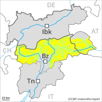
Low avalanche danger will prevail.
On very steep slopes individual mostly small wet loose snow avalanches are possible. Avalanches can in very isolated cases be released by a single winter sport participant. The avalanche prone locations are to be found in particular on very steep shady slopes above approximately 2200 m. Mostly avalanches are small.
Snowpack
The surface of the snowpack will cool hardly at all during the overcast night and will soften quickly. Isolated avalanche prone weak layers exist in the old snowpack especially on steep shady slopes.
The snowpack will be generally subject to considerable local variations. Below the tree line only a little snow is now lying.
Tendency
Low avalanche danger will prevail. The surface of the snowpack will cool hardly at all during the overcast night.
Danger level
treeline
Avalanche Problem
Wet snow
Treeline
Moist and wet avalanches are the main danger. Fresh wind slabs require caution.
On very steep slopes individual mostly small wet loose snow avalanches are possible. Weak layers in the old snowpack can be released in some places by individual winter sport participants. These avalanche prone locations are to be found in particular on steep, little used shady slopes above approximately 2200 m. Mostly avalanches are small. The current avalanche situation calls for careful route selection.
Snowpack
dp.10: springtime scenario
The surface of the snowpack cooled hardly at all during the overcast night and will already be soft in the early morning. Some snow will fall on Saturday in some regions. In addition wind slabs will form in the afternoon. The snowpack will become generally subject to considerable local variations. Precarious weak layers exist deep in the old snowpack on little used shady slopes.
Tendency
On Sunday the wind will be strong over a wide area. In addition wind slabs will form by the evening. The avalanche danger will persist.