New snow and wind slabs are to be assessed with care and prudence.
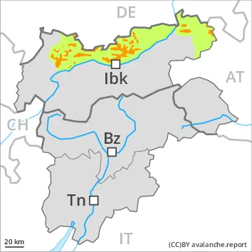
As a consequence of new snow and a strong to storm force wind from northerly directions, wind slabs formed since Saturday. These are covered with new snow in some cases and therefore difficult to recognise. These can be released by a single winter sport participant. Caution is to be exercised in particular adjacent to ridgelines and in gullies and bowls at high altitudes and in high Alpine regions. Mostly avalanches are medium-sized. As a consequence of warming during the day and solar radiation more frequent loose snow avalanches are to be expected. This applies in particular on rocky sunny slopes.
Gliding avalanches can also occur. This applies on grassy slopes below approximately 2400 m, in the regions exposed to a lot of precipitation especially.
Restraint is advisable on this first sunny day.
Snowpack
dp.6: cold, loose snow and wind
20 to 40 cm of snow has fallen since Saturday. The fresh snow and the wind slabs formed during the snowfall are lying on soft layers in all aspects above approximately 2200 m. West, south and east facing slopes below approximately 2400 m: The new snow is lying on a crust.
Tendency
Increase in avalanche danger as a consequence of new snow and wind. The avalanche danger will increase but remain within the current danger level.
Danger level
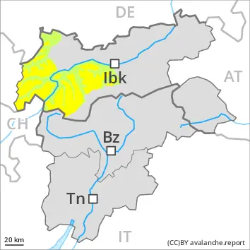
2200m
Avalanche Problem
Persistent weak layer
2200m
Wind slab
2200m
Wind slabs and weakly bonded old snow represent the main danger.
As a consequence of new snow and a sometimes strong wind from northeasterly directions, avalanche prone wind slabs formed since Saturday in particular adjacent to ridgelines and in gullies and bowls. These can be released by a single winter sport participant. This applies in particular on near-ridge shady slopes above approximately 2200 m. As a consequence of warming during the day and solar radiation more frequent loose snow avalanches are to be expected. This applies in particular on rocky sunny slopes.
Weak layers in the upper part of the snowpack can be released by individual winter sport participants. The avalanche prone locations are to be found in particular on steep, little used shady slopes above approximately 2200 m and on steep, little used west and east facing slopes above approximately 2600 m. Mostly avalanches are medium-sized. Restraint is advisable on this first sunny day.
Snowpack
dp.6: cold, loose snow and wind
More snow than expected has fallen. Up to 30 cm of snow, and even more in some localities, has fallen. The new snow is lying on soft layers on shady slopes above approximately 2200 m. Avalanche prone weak layers exist in the old snowpack especially on little used west, north and east facing slopes. This applies in particular above approximately 2200 m.
West, south and east facing slopes below approximately 2200 m: The new snow is lying on a crust.
The snowpack will be subject to considerable local variations at intermediate altitudes. Below the tree line only a little snow is now lying.
Tendency
Gradual decrease in avalanche danger.
Danger level
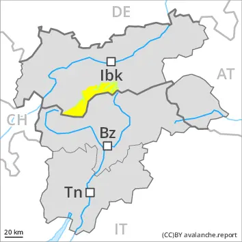
2200m
Avalanche Problem
Persistent weak layer
2200m
Wind slab
2200m
Wind slabs and weakly bonded old snow represent the main danger.
As a consequence of new snow and a sometimes strong wind from northerly directions, avalanche prone wind slabs formed since Saturday in particular adjacent to ridgelines and in gullies and bowls. These can be released by a single winter sport participant. Caution is to be exercised in particular on steep slopes above approximately 2200 m. As a consequence of warming during the day and solar radiation more frequent loose snow avalanches are to be expected. This applies in particular on rocky sunny slopes.
Weak layers in the upper part of the snowpack can be released by individual winter sport participants. The avalanche prone locations are to be found in particular on steep, little used shady slopes above approximately 2200 m and on steep, little used west and east facing slopes above approximately 2600 m. Mostly avalanches are medium-sized. Gliding avalanches can also occur. This applies on grassy slopes below approximately 2400 m, in the regions exposed to a lot of precipitation especially.
Restraint is advisable on this first sunny day.
Snowpack
dp.6: cold, loose snow and wind
20 to 30 cm of snow, and even more in some localities, fell in the past few hours. In some localities up to 20 cm of snow will fall until the early morning. The fresh snow and the small wind slabs formed during the snowfall are lying on soft layers in all aspects above approximately 2200 m. West, south and east facing slopes below approximately 2400 m: The new snow is lying on a crust.
Avalanche prone weak layers exist in the old snowpack especially on little used west, north and east facing slopes. This applies on shady slopes above approximately 2200 m, as well as on west and east facing slopes above approximately 2600 m.
Tendency
The avalanche danger will increase but remain within the current danger level.
Danger level
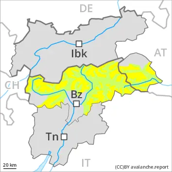
1900m
Avalanche Problem
Wind slab
1900m
Persistent weak layer
2400m
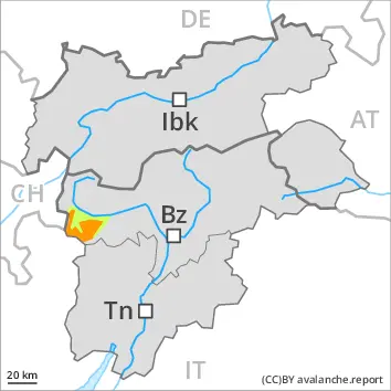
Fresh wind slabs require caution. Weak layers in the old snowpack are treacherous.
Fresh wind slabs are to be evaluated with care and prudence in particular on very steep shady slopes above approximately 1900 m, especially adjacent to ridgelines. Restraint should be exercised because avalanches can sweep people along and give rise to falls.
Weak layers in the old snowpack can still be released in isolated cases by individual winter sport participants. The avalanche prone locations are to be found in particular on steep, little used west, north and east facing slopes above approximately 2400 m. Mostly avalanches are medium-sized. In isolated cases avalanches can also release deeper layers of the snowpack and reach medium size. Some small and, in isolated cases, medium-sized moist loose snow avalanches are possible in particular on steep southeast, south and west facing slopes.
Snowpack
dp.6: cold, loose snow and wind
In some regions up to 5 cm of snow, and even more in some localities, will fall above approximately 1900 m. As a consequence of new snow and a strong to storm force wind from northerly directions, mostly small wind slabs will form especially adjacent to ridgelines. Precarious weak layers exist in the old snowpack especially on steep, little used west, north and east facing slopes.
Tendency
On Sunday the wind will be strong over a wide area. In addition wind slabs will form especially above approximately 1900 m. The avalanche danger will persist.
Danger level
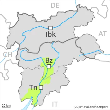
2200m
Avalanche Problem
Wind slab
2200m
Fresh wind slabs are to be avoided.
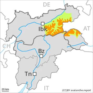
As a consequence of new snow and a strong to storm force wind from northerly directions, mostly shallow wind slabs formed since Saturday. These can be released by a single winter sport participant. Caution is to be exercised in particular on near-ridge slopes at high altitudes and in high Alpine regions. As a consequence of warming during the day and solar radiation more frequent loose snow avalanches are to be expected. This applies in particular on rocky sunny slopes.
Snowpack
dp.6: cold, loose snow and wind
In some regions up to 20 cm of snow has fallen since yesterday. In some localities up to 10 cm of snow will fall in the next few hours. The fresh snow and the small wind slabs formed during the snowfall are lying on soft layers in all aspects above approximately 2200 m. West, south and east facing slopes below approximately 2400 m: The new snow is lying on a crust.
Tendency
Increase in avalanche danger as a consequence of new snow and wind.
Danger level
2200m
Avalanche Problem
Persistent weak layer
2200m
Wind slab
2200m
Wind slabs and weakly bonded old snow require caution.
As a consequence of new snow and a strong to storm force wind from northerly directions, mostly shallow wind slabs formed since Saturday. These can be released by a single winter sport participant. Caution is to be exercised in particular on near-ridge slopes at high altitudes and in high Alpine regions. As a consequence of warming during the day and solar radiation more frequent loose snow avalanches are to be expected. This applies in particular on rocky sunny slopes.
Weak layers in the upper part of the snowpack can be released by individual winter sport participants. The avalanche prone locations are to be found in particular on steep, little used shady slopes above approximately 2200 m and on steep, little used east and west facing slopes above approximately 2600 m. Mostly avalanches are medium-sized.
Snowpack
dp.6: cold, loose snow and wind
Up to 10 cm of snow has fallen since yesterday. In some regions 10 cm of snow will fall in the next few hours. The fresh snow and the small wind slabs formed during the snowfall are lying on soft layers in all aspects above approximately 2200 m. West, south and east facing slopes below approximately 2400 m: The new snow is lying on a crust.
Avalanche prone weak layers exist in the old snowpack especially on little used west, north and east facing slopes. This applies on shady slopes above approximately 2200 m, as well as on west and east facing slopes above approximately 2600 m.
Tendency
Increase in danger as a consequence of new snow and strong wind.
Danger level
2200m
Avalanche Problem
Wind slab
2200m
Persistent weak layer
2200m
Wind slabs and weakly bonded old snow require caution.
Fresh wind slabs are to be evaluated with care and prudence in all aspects above approximately 2200 m. Caution is to be exercised in particular adjacent to ridgelines. Restraint should be exercised because avalanches can sweep people along and give rise to falls.
Weak layers in the old snowpack can still be released in isolated cases by individual winter sport participants. The avalanche prone locations are to be found in particular on steep, little used shady slopes above approximately 2200 m and on steep, little used west and east facing slopes above approximately 2600 m. Mostly avalanches are medium-sized. In isolated cases avalanches can also release deeper layers of the snowpack and reach large size.
Snowpack
dp.6: cold, loose snow and wind
Some snow has fallen in some regions. As a consequence of a storm force wind from northerly directions, mostly small wind slabs formed especially adjacent to ridgelines. The small quantity of fresh snow and the resulting mostly small wind slabs are lying on soft layers in all aspects above approximately 2200 m.
Avalanche prone weak layers exist in the old snowpack. This applies on shady slopes above approximately 2200 m, as well as on west and east facing slopes above approximately 2600 m.
Tendency
Increase in avalanche danger as a consequence of new snow and strong wind, especially on the Main Alpine Ridge.
Danger level
Low avalanche danger will prevail.
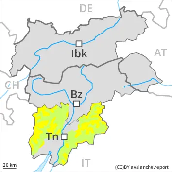
As a consequence of warming during the day and solar radiation individual mostly small wet loose snow avalanches are possible. Avalanches can in very isolated cases be released by a single winter sport participant. The avalanche prone locations are to be found in particular on very steep shady slopes above approximately 2200 m. Mostly avalanches are small.
Snowpack
The surface of the snowpack will only just freeze and will soften quickly. Isolated avalanche prone weak layers exist in the old snowpack especially on steep shady slopes.
The snowpack will be generally subject to considerable local variations. Below the tree line only a little snow is now lying.