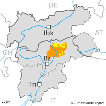
With the end of the precipitation, the natural activity of wet avalanches will decrease. Fresh wind slabs in the high Alpine regions.
With the end of the intense precipitation, the natural activity of wet avalanches will appreciably decrease. As the temperature drops there will be a decrease in the avalanche danger to level 2 (moderate) by the early morning. Wet avalanches can as before be released by a single winter sport participant. The avalanche prone locations are to be found especially on very steep west, north and east facing slopes below approximately 2600 m. Avalanches can release the saturated snowpack and reach medium size. Individual gliding avalanches can also occur, caution is to be exercised in particular on very steep grassy slopes in the regions with a lot of snow.
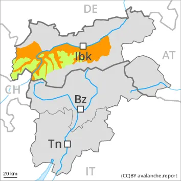
As a consequence of new snow and a strong to storm force wind from southeasterly directions, extensive wind slabs formed above approximately 2600 m. The fresh wind slabs can be released easily in some places especially on very steep shady slopes. Avalanches can in isolated cases reach large size. Such avalanche prone locations are to be found in gullies and bowls, and behind abrupt changes in the terrain.
In high Alpine regions small to medium-sized moist loose snow avalanches are to be expected. In the event of prolonged bright spells this applies in particular on extremely steep sunny slopes.
Snowpack
dp.10: springtime scenario dp.6: cold, loose snow and wind
The rain gave rise to a loss of strength within the snowpack below approximately 2600 m. Already many wet avalanches have been released in particular on very steep west, north and east facing slopes. The snowpack will be wet all the way through. This applies on shady slopes below approximately 2600 m, as well as on sunny slopes below approximately 3000 m. On steep sunny slopes as well as at low and intermediate altitudes only a little snow is now lying. As a consequence of falling temperatures the snowpack will consolidate during the course of the night.
High Alpine regions: Over a wide area 40 to 80 cm of snow, and up to 100 cm in some localities, has fallen since Wednesday. As a consequence of new snow and a strong to storm force wind from southeasterly directions, extensive wind slabs formed. These are lying on soft layers on steep shady slopes. The weather effects will foster a gradual strengthening of the snow drift accumulations.
Tendency
The surface of the snowpack will cool hardly at all during the overcast night and will already be soft in the early morning. Wet snow requires caution.
EARLIER Danger level
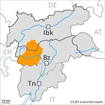
2600m
Avalanche Problem
Wet snow
2600m
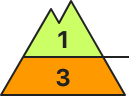
Wind slab
2600m
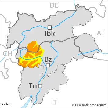
LATER Danger level
2600m
Avalanche Problem
Wet snow
2600m
Wind slab
2600m
With the end of the precipitation, the natural activity of wet avalanches will decrease. Fresh wind slabs in the high Alpine regions.
With the end of the intense precipitation, the natural activity of wet avalanches will appreciably decrease. As the temperature drops there will be a decrease in the avalanche danger to level 2 (moderate) by the early morning. Wet avalanches can as before be released by a single winter sport participant. The avalanche prone locations are to be found especially on very steep west, north and east facing slopes below approximately 2600 m. Avalanches can release the saturated snowpack and reach medium size. Individual gliding avalanches can also occur, caution is to be exercised in particular on very steep grassy slopes in the regions with a lot of snow.
As a consequence of new snow and a strong to storm force wind from southeasterly directions, extensive wind slabs formed above approximately 2600 m. The fresh wind slabs can be released easily in some places especially on very steep shady slopes. Such avalanche prone locations are to be found in gullies and bowls, and behind abrupt changes in the terrain. In regions exposed to heavier precipitation the avalanche prone locations are more prevalent and the danger is slightly greater.
In high Alpine regions small to medium-sized moist loose snow avalanches are to be expected. In the event of prolonged bright spells this applies in particular on extremely steep sunny slopes.
Snowpack
dp.10: springtime scenario dp.6: cold, loose snow and wind
The rain gave rise to a loss of strength within the snowpack. Already many wet avalanches have been released in particular on very steep west, north and east facing slopes. The snowpack will be wet all the way through. This applies on shady slopes below approximately 2600 m, as well as on sunny slopes below approximately 3000 m. On steep sunny slopes as well as at low and intermediate altitudes only a little snow is now lying. As a consequence of falling temperatures the snowpack will consolidate during the course of the night.
High Alpine regions: Over a wide area 20 to 60 cm of snow, and even more in some localities, has fallen since Wednesday. As a consequence of new snow and a strong to storm force wind from southeasterly directions, extensive wind slabs formed. These are lying on soft layers on steep shady slopes. The weather effects will foster a rapid strengthening of the snow drift accumulations.
Tendency
The surface of the snowpack will cool hardly at all during the overcast night and will already be soft in the early morning. Wet snow requires caution.
EARLIER Danger level
2600m
Avalanche Problem
Wet snow
2600m
Wind slab
2600m
LATER Danger level
2600m
Avalanche Problem
Wet snow
2600m
Wind slab
2600m
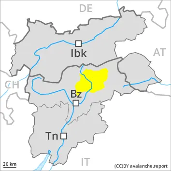
With the end of the precipitation, the natural activity of wet avalanches will decrease.
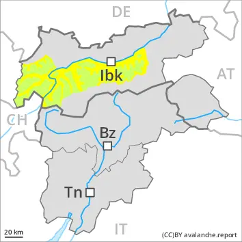
With the end of the intense precipitation, the natural activity of wet avalanches will appreciably decrease. As the temperature drops there will be a decrease in the avalanche danger to level 2 (moderate) by the early morning. Wet avalanches can as before be released by a single winter sport participant. The avalanche prone locations are to be found especially on very steep west, north and east facing slopes below approximately 2600 m. Avalanches can release the saturated snowpack and reach medium size in isolated cases.
As a consequence of new snow and a strong to storm force wind from southeasterly directions, wind slabs formed above approximately 2600 m. The fresh wind slabs can be released by a single winter sport participant in isolated cases especially on very steep shady slopes. Such avalanche prone locations are to be found in gullies and bowls, and behind abrupt changes in the terrain.
Snowpack
dp.10: springtime scenario dp.6: cold, loose snow and wind
The rain gave rise to a loss of strength within the snowpack. Already many wet avalanches have been released in particular on very steep west, north and east facing slopes. The snowpack will be wet all the way through. This applies on shady slopes below approximately 2600 m, as well as on sunny slopes below approximately 3000 m. On steep sunny slopes as well as at low and intermediate altitudes only a little snow is now lying. As a consequence of falling temperatures the snowpack will consolidate during the course of the night.
High Alpine regions: Over a wide area 20 to 40 cm of snow, and even more in some localities, has fallen since Wednesday. As a consequence of new snow and a strong to storm force wind from southeasterly directions, wind slabs formed in isolated cases. These are lying on soft layers on steep shady slopes. The weather effects will facilitate a rapid strengthening of the snow drift accumulations.
Tendency
The surface of the snowpack will cool hardly at all during the overcast night and will already be soft in the early morning. Wet snow requires caution.
Danger level
Avalanche Problem
Wet snow
Gliding snow
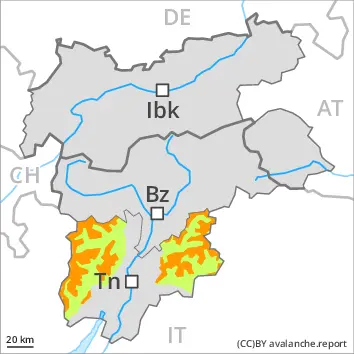
Wet and gliding snow represent the main danger.
Wet avalanches can in some cases be released by a single winter sport participant. The avalanche prone locations are to be found especially on very steep west, north and east facing slopes at high altitude. Avalanches can release the saturated snowpack and reach medium size in isolated cases.
Individual gliding avalanches can also occur. Such avalanche prone locations are to be found in particular on very steep grassy slopes. Areas with glide cracks are to be avoided as far as possible.
Snowpack
dp.10: springtime scenario dp.2: gliding snow
The snowpack will be wet all the way through. This applies on shady slopes below approximately 2400 m, as well as on sunny slopes in all altitude zones. On steep sunny slopes as well as at low and intermediate altitudes only a little snow is now lying.
Tendency
During the night the weather will be clear at times. At high altitudes and in high Alpine regions the snowpack will freeze and form a strong crust. The surface of the snowpack will soften during the day. In the regions where the outgoing longwave radiation during the night is reduced the danger will increase more quickly.
Danger level
1800m
Avalanche Problem
Wet snow
2600m
1800m
Wind slab
2400m
Wet snow represents the main danger. The new snow and wind slabs of the last few days must be evaluated with care and prudence above approximately 2400 m.
The conditions are unfavourable for backcountry touring. In particular on very steep slopes and below approximately 2600 m numerous medium-sized and, in isolated cases, large moist and wet avalanches are possible as the moisture increases. In particular on very steep west, north and east facing slopes medium-sized to large moist and wet avalanches are to be expected. In isolated cases, the avalanches can reach areas without any snow cover in steep gullies.
Fresh wind slabs can be released by a single winter sport participant in some cases in particular on very steep west, north and east facing slopes above approximately 2400 m. Such avalanche prone locations are to be found in particular adjacent to ridgelines and in gullies and bowls.
Snowpack
dp.3: rain dp.6: cold, loose snow and wind
The rain gave rise to increasing and thorough wetting of the snowpack below approximately 2200 m. This situation will give rise to a loss of strength within the snowpack in particular on steep slopes. In some regions 40 to 70 cm of snow, and even more in some localities, has fallen since Tuesday above approximately 2500 m. As a consequence of new snow and a sometimes strong southerly wind, sometimes avalanche prone wind slabs formed in particular adjacent to ridgelines and in gullies and bowls.
Tendency
Slight decrease in danger of wet avalanches as a consequence of the ceasing of precipitation. The surface of the snowpack will cool hardly at all during the overcast night will already be soft in the early morning. Wet snow represents the main danger. The new snow and wind slabs must be evaluated with care and prudence in high Alpine regions.
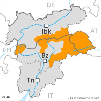
EARLIER Danger level
2800m
Avalanche Problem
Wet snow
2800m
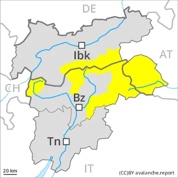
LATER Danger level
2600m
Avalanche Problem
Wet snow
2600m
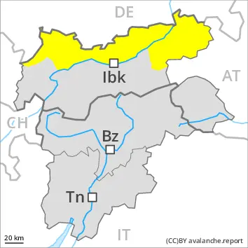
With the end of the precipitation, the natural activity of wet avalanches will decrease.
With the end of the precipitation, the natural activity of wet avalanches will decrease. As the temperature drops there will be a decrease in the avalanche danger to level 2 (moderate) by the early morning. Wet avalanches can as before be released by a single winter sport participant. The avalanche prone locations are to be found especially on very steep west, north and east facing slopes below approximately 2600 m. Avalanches can release the saturated snowpack and reach medium size. Individual gliding avalanches can also occur, caution is to be exercised in particular on very steep grassy slopes in the regions with a lot of snow.
Fresh wind slabs can be released by a single winter sport participant in isolated cases on very steep shady slopes in high Alpine regions. This applies especially in the south.
Snowpack
dp.10: springtime scenario dp.2: gliding snow
The rain gave rise to a loss of strength within the snowpack. Already many wet avalanches have been released in particular on very steep west, north and east facing slopes. The snowpack will be wet all the way through. This applies on shady slopes below approximately 2600 m, as well as on sunny slopes below approximately 3000 m. On steep sunny slopes as well as at low and intermediate altitudes only a little snow is now lying. As a consequence of falling temperatures the snowpack will consolidate during the course of the night.
High Alpine regions: Over a wide area 5 to 15 cm of snow has fallen since Wednesday, especially in the south. As a consequence of new snow and a strong to storm force wind from southeasterly directions, wind slabs formed in isolated cases. The weather effects will bring about a rapid strengthening of the snow drift accumulations.
Tendency
During the night the weather will be clear at times, especially in the north. At high altitudes and in high Alpine regions the snowpack will freeze and form a strong crust. The surface of the snowpack will soften during the day. In the regions where the outgoing longwave radiation during the night is reduced the danger will increase more quickly.
Danger level
2000m
Avalanche Problem
Wet snow
2000m
Wet snow represents the main danger.
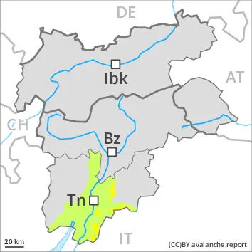
As a consequence of the heavy precipitation individual wet avalanches are possible, but they will be mostly small. In particular in the Vallarsa and adjacent to ridgelines and in gullies and bowls medium-sized and, in isolated cases, large wet loose snow avalanches are possible in particular above approximately 1800 m.
Snowpack
dp.3: rain
The surface of the snowpack will cool hardly at all during the overcast night and will already be soft in the early morning. The rain will give rise to increasing and thorough wetting of the snowpack. Below approximately 1800 m a little snow is lying.
Tendency
Wet snow requires caution.
Danger level
Low avalanche danger will prevail.
Hardly any more wet avalanches are to be expected.
Snowpack
Outgoing longwave radiation during the night will be severely restricted. The surface of the snowpack will cool hardly at all during the overcast night and will already be soft in the early morning. The snowpack will be wet all the way through. Only a little snow is now lying.
Tendency
Hardly any more wet avalanches are to be expected.